
~~~~~~~~~~~~~~~~~~~~~~
TABLE OF CONTENTS
* Daily Celestials (Sun/Moon Data)
* Weekly Weather Nutshell
* Morning Discussion
* TIP: Scroll below for sections, or read all
~~~~~~~~~~~~~~~~~~~~~~
YOUR DAILY CELESTIALS
~~~~~~~~~~~~~~~~~~~~~~
STAR:
–OUR STAR ROSE AT: 6:23am this morning
–OUR STAR WILL SET AT: 7:22pm this evening
–TOTAL DAYLIGHT TIME: 12 hours and 59 minutes
MOON:
–OUR MOON WILL SET AT: 4:56pm this morning
–MOON SET DIRECTION: West
–OUR MOON WILL RISE AT: 5:51am tomorrow morning
–MOON RISE DIRECTION: East
–MOON PHASE: Waning Gibbous (67.5%)
~~~~~~~~~~~~~~~~~~~~~~
>>> A NOTE FROM OUR SPONSOR <<<
Dave Hayes The Weather Nut is Sponsored by Individual Community Members, Patrons, and Gerard, Ghazey & Bates, P.C. GGBPC is a Northampton-based law firm regarded as the voice of pragmatic and well-reasoned estate planning, elder law and tax guidance in Western Massachusetts. The firm specializes in estate planning law, and expertly handles other matters such as Elder Law, Tax Law, as well as Real Estate purchase, sales, and refinance transactions. Contact GGBPC today to see how they can help!
~~~~~~~~~~~~~~~~~~~~~~
YOUR WEEKLY WEATHER NUTSHELL
~~~~~~~~~~~~~~~~~~~~~~
–A few isolated showers this morning, with periods of partly sunny skies with cloudier periods as well into the afternoon
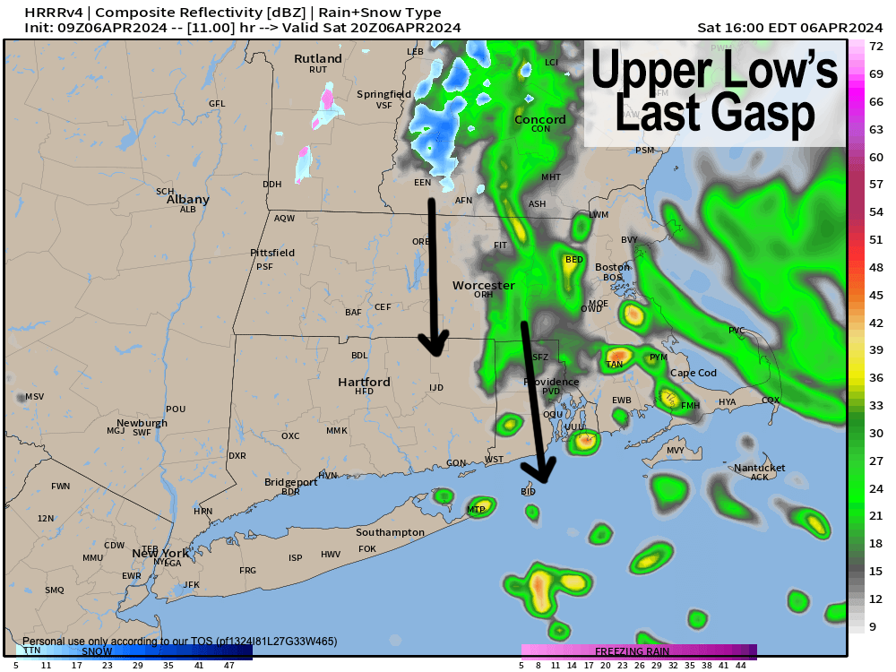
–Our upper low wanders around in the Gulf of Maine and finally kicks out to the southeast and east
–As it does so, a final round of showers will drop south through SWNH, CMass and far northeast CT this afternoon and early evening
–Northerly gusts of 15-25mph are expected
–Highs will reach the upper 30s to mid 40s, and some CMass hilly areas could see snow showers this late PM
–Lows tonight dip into the upper 20s to low 30s as unsettled weather finally ends after a long, multi-day stretch
–Sunday looks nicer, milder as high pressure starts to nose in from the west and northwest
–Highs should climb into the 45-50º range under partly sunny skies (more clouds in the AM, more sun in the PM)
–Lows again will dip to the upper 20s to low 30s
–Monday looks lovely, as does Tuesday for that matter!
–Mostly sunny skies are expected for both days with highs in the mid 50s to low 60s Monday, and upper 50s to mid 60s on Tuesday with lows 35-40
–This should be ideal for Eclipse viewing, as the full solar eclipse passes between 3:25pm and 3:30pm, with totality as close as the Middlebury, VT area (we’ll be at 92% here)
–By Wednesday, another storm system will be getting its act together to our west, and likely pass well north of us by late week
–Mild temperatures will continue, though Wednesday will be cooler, rising to either side of 50º, with 50s to low 60s during the late week period
–While timing and intensity is still uncertain, Thursday and Friday are looking rather wet, so more rain is likely on the way
~~~~~~~~~~~~~~~~~~~~~~
YOUR MORNING DISCUSSION
~~~~~~~~~~~~~~~~~~~~~~
Good morning folks, ok then, well, we’ve kicked off April with a late-season winter storm, SleetFest2024, over a foot of snow in parts of SVT, plenty of rain, thunder, and now an earthquake, let’s keep the frikkin’ tornadoes and hurricanes away, please!
Going forward, it looks like we’ll do just that with more tranquil weather expected through mid-week, with a final glancing shot of rain showers along with some wintry mix in the high terrain later this afternoon.
There have been some isolated showery bits this morning, but it’s the afternoon and early evening when a wave swinging around the west side of our departing upper low in the Gulf of Maine drops an area of mixed showers through SWNH / CMass / NE.CT and points east later this afternoon.
It shouldn’t amount to much, and northerly wind gusts of 15-25mph will be drawn through the greater WMass region as well, with highs in the upper 30s to mid 40s.
Enjoy any sunny breaks, as clouds should build during the day. Lows tonight will dip into the upper 20s to low 30s.
The Nutshell above handles the Sunday through Tuesday period well as we transition into milder temperatures (low to mid 60s by Tuesday!), and sunnier skies, along with drier conditions, which are most welcome at this point!
By the time we get to Wednesday, that looks to be our transition day back into more unsettled conditions, though no wintry precipitation is expected given the much milder temperature regime that will be in place.
Wednesday *should* be a mostly dry day, but clouds likely build into the region with highs either side of 50º.
By Wednesday night into Thursday we may be dealing with some warm frontal overrunning type rain showers, prior to the actual storm tracking northeast through the eastern Great Lakes and sweeping a slug of rainfall through the greater WMass region Thursday into Friday, with mild temps well into the 50s to low 60s.
At least it won’t be anything severe or wintry, but it would be nice if we could get a break in the precipitation action, though something something about April showers bring May flowers etc…
Have a great day, folks!
>>> BE KIND <<<
“Hello babies. Welcome to Earth. It’s hot in the summer and cold in the winter. It’s round and wet and crowded. On the outside, babies, you’ve got a hundred years here. There’s only one rule that I know of, babies: Goddamn it, you’ve got to be kind.”
–Kurt Vonnegut