
TABLE OF CONTENTS
* Daily Celestials (Sun/Moon Data)
* Morning Discussion
* TIP: Scroll below for sections, or read all
~~~~~~~~~~~~~~~~~~~~~~
YOUR DAILY CELESTIALS
~~~~~~~~~~~~~~~~~~~~~~
STAR:
–OUR STAR ROSE AT: 6:27am this morning
–OUR STAR SETS AT: 7:19pm this evening
–TOTAL DAYLIGHT TIME: 12 hours and 52 minutes
MOON:
–OUR MOON SETS AT: 2:16pm this afternoon
–MOON SET DIRECTION: West-Southwest
–OUR MOON RISES AT: 5:01am tomorrow morning
–MOON RISE DIRECTION: East-Southeast
–MOON PHASE: Waning Crescent (25.2%)
~~~~~~~~~~~~~~~~~~~~~~
A NOTE FROM OUR SPONSOR
~~~~~~~~~~~~~~~~~~~~~~
Dave Hayes The Weather Nut is Sponsored by Individual Community Members, Patrons, and Tandem Bagel Company… No matter the weather, Tandem Bagel is always there for you at several valley locations to make your mornings brighter! With *New Pizza Bagels(!)*, along with bagels baked fresh daily (including Gluten-Free options), house-whipped cream cheese, coffee, and tons of lunch options, Tandem is the perfect quick stop for lunch, breakfast, or a coffee and bagel to go. Find them in Easthampton, Northampton, Hadley, Florence, and West Springfield, or use their super-streamlined online ordering tool by visiting their website.
~~~~~~~~~~~~~~~~~~~~~~
YOUR MORNING DISCUSSION
~~~~~~~~~~~~~~~~~~~~~~
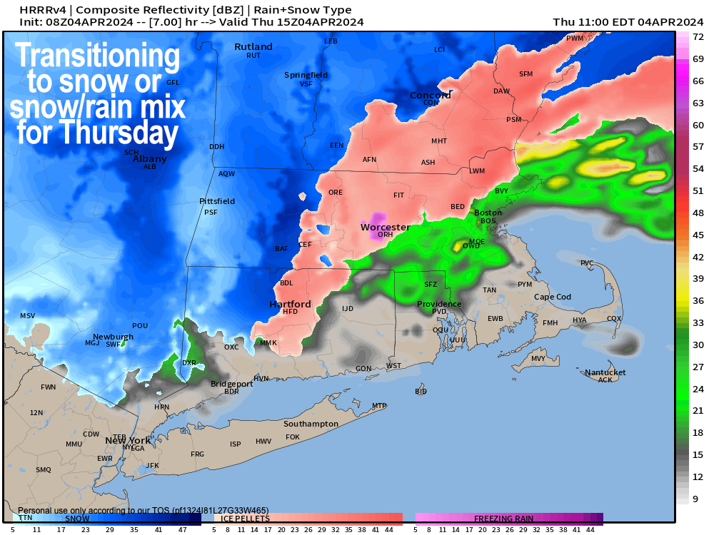
Good morning everybody, many of us are waking up to quite a wintry scene with at least 6″ reported in Plainfield, MA and Colrain, MA earlier this morning, with snow, sleet and rain (depending on where you are) still falling as our potent secondary storm tracks toward Cape Cod.
Temps are in the mid 30s or so in the southern valley, but I’m seeing lots of 20s in SVT, SWNH and down into the western hilltowns and Berkshires, so it’s a bit colder at this time than was expected yesterday, and that is due to our storm tracking a touch more south.
Cold air damming (a drain from high pressure of colder air from north to south at the Earth’s surface) is also evident on surface pressure fields this morning from Maine southwest into our region so many are seeing snow, snow/sleet mix or sleet this morning, with some rain reported in Westfield and points south.
Please let me know how much snow/sleet you’ve received and what it’s doing where you live!
Also please be aware that Mountain Road Easthampton Rt 141 is closed to travel until further notice as of this morning as per the Easthampton Police Department.
For this morning, a final pivoting band of snow and mix showers are swinging through the region, and should continue into the afternoon before tapering off before sunset, which will provide additional snow/sleet accumulations.
Some freezing rain may be present in isolated areas, but I don’t see much of a freezing rain threat at the moment for today.
Take it easy on the roads due to slippery surfaces where roads are untreated, or in any heavier wintry precip this morning before the sun angle can climb and do some work on surfaces.
Highs will pretty much stay where they’re at, getting into the 30s for most folks.
Winds will tamp down as the morning and afternoon wears on, though we have had gusts of 30-50mph earlier this morning, and into the 60s yesterday.
Here are current power outage numbers:
WMass & CMass = 6500
Southwest NH – 2600
Southern VT = 2200
Northern CT = 5000 with a recent spike in Tolland Cty.
Taconics = Several thousand
Here are my snow/sleet totals, basically the same as yesterday (report continues below that), these are through Friday morning, as mentioned before.
SNOW/SLEET AMOUNTS
I still think 6-12″ is reasonable to expect in southern VT (except for the Bennington area, 2-6″ there), southwest NH, the northern Berkshires and northwest hilltowns of western Franklin / Hampshire Counties under the Warning.
Some parts of SVT could see over a foot.
I believe more like 2-6″ is possible in northern CMass (though border towns with NH should be more like 4-10″), southern Berkshire County and western Hampden County and the Taconics (including Bennington area) down into far northern Litchfield County.
The eastern Franklin County highlands are also included in this 2-6″ range.
A coating to 3″ is in the Pioneer Valley, little if any north-central and northeast CT, but some elevated areas may get C-1″.
Our storm clears out tonight with lows either side of 30º, and then we’ll be under the influence of our upper low over the next couple of days (Friday and Saturday) with scattered rain or snow showers, with some graupel possible.
Highs will reach the mid 30s to mid 40s both days with lows near freezing, and some additional light accumulations are possible in the high terrain, but mostly we’ll just see scattered activity.
By Sunday, high pressure starts building in and kicks what is more likely than not our final winter type patterned storm system out to sea, as Spring is set to SPRING into action in the greater WMass region.
Partly sunny skies will develop on Sunday with highs in the 40s to near 50º, before we bounce up and well into the 50s for highs on Monday and Tuesday with plenty of sunshine, and great conditions for the total Solar Eclipse on Monday afternoon!
Sunny weather is climatologically unfavored for this time of year, so folks won’t have to go far to make their neck hairs stand up straight as totality kicks up some wind, drops temps, darkness falls, pressure changes, and reminds us that we’re all galactic citizens first and foremost… it’s too bad we can’t seem to have that big picture experience more often, but our lives pull us constantly back into the pressing matters of the day.
Truly, such is life.
Have a great day, and if you didn’t get a chance during my support drive and would like to support my work today, you can donate at any level at this secure link, thank you.
>>> BE KIND <<<
“Hello babies. Welcome to Earth. It’s hot in the summer and cold in the winter. It’s round and wet and crowded. On the outside, babies, you’ve got a hundred years here. There’s only one rule that I know of, babies: Goddamn it, you’ve got to be kind.”
–Kurt Vonnegut