
~~~~~~~~~~~~~~~~~~~~~~
TABLE OF CONTENTS
* Daily Celestials (Sun/Moon Data)
* Morning Discussion
* TIP: Scroll below for sections, or read all
~~~~~~~~~~~~~~~~~~~~~~
YOUR DAILY CELESTIALS
~~~~~~~~~~~~~~~~~~~~~~
STAR:
–OUR STAR ROSE AT: 6:28am this morning
–OUR STAR SETS AT: 7:18pm this evening
–TOTAL DAYLIGHT TIME: 12 hours and 50 minutes
MOON:
–OUR MOON SETS AT: 12:57pm this afternoon
–MOON SET DIRECTION: West-Southwest
–OUR MOON RISES AT: 4:31am tomorrow morning
–MOON RISE DIRECTION: East-Southeast
–MOON PHASE: Waning Crescent (35.8%)
~~~~~~~~~~~~~~~~~~~~~~
A NOTE FROM OUR SPONSOR
~~~~~~~~~~~~~~~~~~~~~~
Dave Hayes The Weather Nut is Sponsored by Individual Community Members, Patrons, and Tandem Bagel Company… No matter the weather, Tandem Bagel is always there for you at several valley locations to make your mornings brighter! With *New Pizza Bagels(!)*, along with bagels baked fresh daily (including Gluten-Free options), house-whipped cream cheese, coffee, and tons of lunch options, Tandem is the perfect quick stop for lunch, breakfast, or a coffee and bagel to go. Find them in Easthampton, Northampton, Hadley, Florence, and West Springfield, or use their super-streamlined online ordering tool by visiting their website.
~~~~~~~~~~~~~~~~~~~~~~
YOUR MORNING DISCUSSION
~~~~~~~~~~~~~~~~~~~~~~
Good morning everybody, our storm system is starting to become a little more clear in terms of how it is more likely to play out, and first on the docket is more rainfall that is moving into the region this morning, already starting to wet the ground in northwest CT and southwest MA as the dawn dawns across our cloud-covered hills and dales.
Temps are in the 30s and 40s this morning, and slightly below freezing in SVT.
Highs won’t really change all that much today from where temps are currently, but the more interesting note to our temps has to do with where they’re at close to a mile up, which is above freezing.
At the same time, high pressure to our northeast is draining a thicker layer of cold air below that warm layer southwest through our greater WMass region.
This will cause sleet to develop in the high terrain later this morning and into the afternoon, and we could even see some sleet mix in to the Pioneer Valley of WMass north of the Pike and into parts of CMass.
So expect temps to more or less hold steady, with rain overspreading the region this morning, with sleet developing or mixing in later, depending on elevation.
By afternoon, our secondary low will develop more down near Virginia, and we’ll start to increase an east wind off of the ocean, and it will become breezy with gusts to 30mph at first.
Our low level easterly jet streak associated with the developing secondary low that is set to pass just off the coast and to our south tonight will swing overhead by mid to late afternoon through the evening/night.
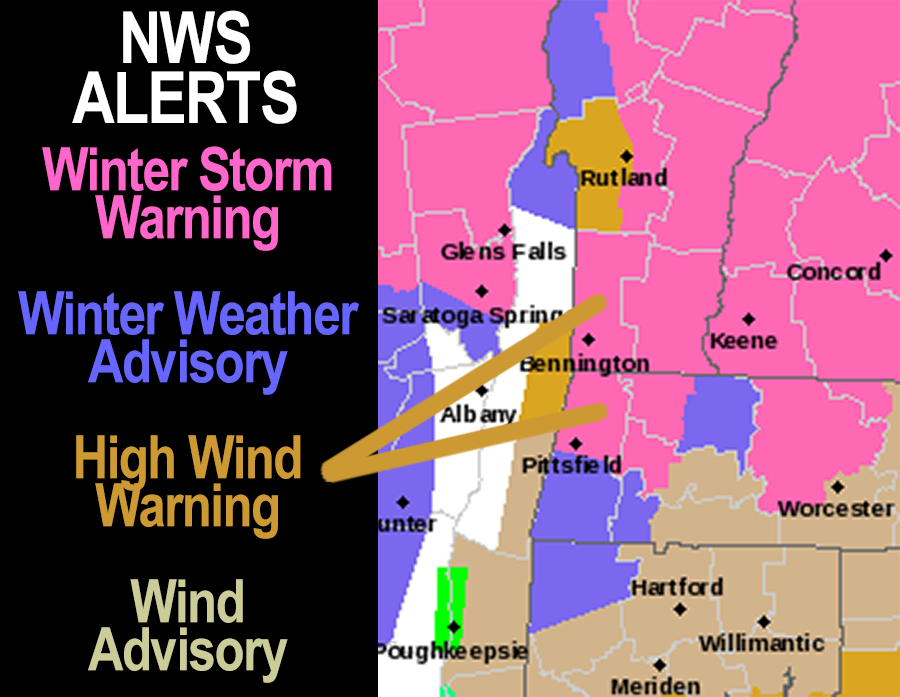
This is when the peak winds will pick up and gust 25-45mph in the Pioneer Valley floor, and between 40-60mph with a few gusts up to 65mph in the high terrain, especially in downsloping areas of the western Berkshires into the Taconics, and western Bennington County off of the Green Mountains.
Sleet and snow will start to develop in the high terrain tonight, turning to all snow around or after midnight in far northwest MA, northern CMass and SVT/SWNH where 6-12″ with some foot-plus amounts are expected by Friday morning.
And don’t be surprised if you get a pile of up to one inch of ice pellets through the afternoon and early evening in the high terrain, either! #sleetfest2024
Some freezing rain is possible in SVT or northwest MA, but we’ll have a much thicker layer of colder air just aloft, so I think sleet is the main issue before snow develops tonight into Thursday morning.
In the CT River Valley of WMass south of Greenfield down to Hartford and east through northeast CT and southern CMass we will see sleet mix in with rain, heavy at times, by this afternoon and evening, and it could turn to all sleet for a time later tonight even down into the lower Pioneer Valley. Lows will drop to the low to mid 30s with gusty winds.
A stormy night lies ahead as colder air works into the region, and should flip even the highlands of eastern Franklin County over to snow in the pre-dawn hours into Thursday morning, or a snow/sleet mix, with 1-4″ of snow and sleet possible there, with a coating to an inch possible in the valley by noon on Thursday, but should mostly be a sloppy mess in the valley or rain, sleet and snow.
The real flip to heavy snow overnight occurs in SVT, the northern Berkshires (esp. the northeast county), northwestern hilltowns, and far northern CMass up into SWNH as well, with some sleet mixed.
As strong easterly gusts continue there with wet snow accumulating, power outages will develop, especially in parts of SWNH, SVT and northwestern MA, with some in northern CMass as well.
As our coastal low tracks and tucks closer to our region than originally thought, this should keep the valley floor and points south and east mild enough to preclude any substantial icy or snowy accumulations, though some coatings to an inch or so are possible of snow and sleet by Thursday morning.
More importantly, a dry slot to the south of our storm’s main precip shield should punch into our region south of Rt 2 and cause lighter mixed precip to fall across much of the area by later tomorrow morning into the afternoon, with continued snow/sleet north of Rt. 2 as wind starts to tamp down later in the afternoon with highs in the 30s.
SNOW/SLEET AMOUNTS
I still think 6-12″ is reasonable to expect in southern VT (except for the Bennington area, 2-6″ there), southwest NH, the northern Berkshires and northwest hilltowns of western Franklin / Hampshire Counties under the Warning.
Some of these areas could easily exceed a foot of snow, so please send in your reports by tomorrow!
I believe more like 2-6″ is possible in northern CMass (though border towns with NH should be more like 4-10″), southern Berkshire County and western Hampden County and the Taconics (including Bennington area) down into far northern Litchfield County.
The eastern Franklin County highlands are also included in this 2-6″ range.
A coating to 2″ is possible in northern parts of the Pioneer Valley, but once you get south of Northampton it’s probably just slushy coatings with more rain than any other precip type during the heaviest of the precip through Thursday morning.
FRIDAY INTO MONDAY
Friday and Saturday should feature chances of scattered mixed showers with highs in the 30s and 40s before we break out into the sunshine by Sunday and Monday which looks good for the full solar eclipse!
WILL DO MY BEST
As I mentioned, I am in the midst of a long-planned and involved live recording for my band King Radio, and we have practices, dinner, and the actual recording from 4-9pm today/tonight, so while I might try to squeeze in a quick post during my dinner break, I will only be able to post a mid-afternoon update, which I will definitely do, and then post a quick update after I get home tonight.
Have a great day!!!
>>> BE KIND <<<
“Hello babies. Welcome to Earth. It’s hot in the summer and cold in the winter. It’s round and wet and crowded. On the outside, babies, you’ve got a hundred years here. There’s only one rule that I know of, babies: Goddamn it, you’ve got to be kind.”
–Kurt Vonnegut