
TABLE OF CONTENTS
* Daily Celestials (Sun/Moon Data)
* Morning Discussion
* TIP: Scroll below for sections, or read all
~~~~~~~~~~~~~~~~~~~~~~
YOUR DAILY CELESTIALS
~~~~~~~~~~~~~~~~~~~~~~
STAR:
–OUR STAR ROSE AT: 6:30am this morning
–OUR STAR SETS AT: 7:17pm this evening
–TOTAL DAYLIGHT TIME: 12 hours and 47 minutes
MOON:
–OUR MOON SETS AT: 11:42am this morning
–MOON SET DIRECTION: Southwest
–OUR MOON RISES AT: 3:54am tomorrow morning
–MOON RISE DIRECTION: Southeast
–MOON PHASE: Waning Crescent (46.4%)
~~~~~~~~~~~~~~~~~~~~~~
A NOTE FROM OUR SPONSOR
~~~~~~~~~~~~~~~~~~~~~~
Dave Hayes The Weather Nut is Sponsored by Individual Community Members, Patrons, and Tandem Bagel Company… No matter the weather, Tandem Bagel is always there for you at several valley locations to make your mornings brighter! With *New Pizza Bagels(!)*, along with bagels baked fresh daily (including Gluten-Free options), house-whipped cream cheese, coffee, and tons of lunch options, Tandem is the perfect quick stop for lunch, breakfast, or a coffee and bagel to go. Find them in Easthampton, Northampton, Hadley, Florence, and West Springfield, or use their super-streamlined online ordering tool by visiting their website.
~~~~~~~~~~~~~~~~~~~~~~
YOUR MORNING DISCUSSION
~~~~~~~~~~~~~~~~~~~~~~
Good morning everybody, I cover a 10,000 square mile region (primarily northern CT, WMass, CMass, SVT and SWNH) and in that geographical box we will see snow, sleet, freezing rain, rain, wind, power outages, and potentially even some flooding (though that’s a very low chance for areas in parts of CT) over the next 4 days.
I can’t believe I am talking about such a storm in early April, but here we are, and here it comes, so I’ll do my best to parse it out for you.
For today, clouds should dominate though a few sunny peeks are possible early this morning.
Clouds thicken as the day wears on, and highs will climb into the 40s as a warm front approaches the region from the southwest, but never quite makes it through our region, staying south of us.
However, warm advection showers will form and push northeast into the WMass region while drier air from a high to our north and northeast will push southwest towards the greater WMass region to meet up with this incoming moisture.
In addition, a weak wave of low pressure will run southeast along this warm front, staying again to our south, but adding some lift to the whole operation.
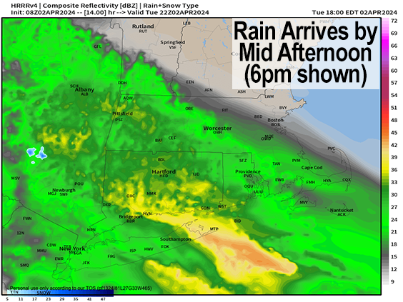
All of this will combine to produce showers that mostly spare parts of northeast Worcester County and a portion of southwest NH, but move into SVT, WMass, northwest/central CT, and the Taconics by early to mid afternoon and quit/move out before midnight.
Some areas in SVT and the high terrain of northwest MA will likely mix with or even change to snow or sleet and could accumulate a coating to an inch or two by early Wednesday morning as lows tonight will drop into the low to mid 30s.
For Wednesday, highs will only reach the mid 30s to low 40s as our primary low pressure system pushes into the southern Great Lakes but gets stymied as it tries to push further east past Ohio by blocking high pressure to our northeast, which takes the shape of a northeastward-bulging banana (a/k/a “banana high”).
Regardless, a strong precipitation shield will be sent northeastward into our region, and rain will redevelop across the region by mid to late Wednesday morning, with periods of light to moderate rain all day long, with snow and sleet mixing in and changing over in the northern Berkshires, northwest hilltowns, SVT and SWNH by mid day into the early/mid afternoon.
It will be tough to accumulate wintry precip in those areas with peak sun angle during the mid-day, but if during heavier showers it could accumulate, and will do so in earnest by later afternoon and evening.
This will be due to our secondary low developing somewhere out of the DelMarVa Peninsula to Delaware Bay area (which I flew over on my way home from FL on Saturday, which is always super cool for me to see) and slowly tracking northeast south of Long Island.
As this happens, colder air will be drawn down from our north Wednesday night, and flip high terrain areas to snow, with mixes of snow or sleet even into the Pioneer Valley as temps drop into the low to mid 30s.
There is a chance that a warm nose a mile aloft will precede this atmospheric operation and produce a period of accumulating sleet, but I think that gets shut off by Wednesday night as we head past midnight.
The bottom line is that as our secondary low tracks toward Cape Cod, colder air will be pulled into our region, especially as that low reaches and passes east of our longitude Wednesday night into Thursday.
Snow will develop in SVT, SWNH, and northern MA down the spine of the western hilltowns and eastern Berkshires, possibly into northern Litchfield County Wednesday night into Thursday with heavy snow at times.
At the same time, easterly winds will develop as our secondary low pushes off the NJ coastline, and gust up to 35-60mph Wednesday late afternoon into Thursday, causing power outages with wet snow accumulating on power lines in the high terrain.
The High Wind Watches for gusts up to 65mph are hoisted in Bennington County and the northern Berkshires primarily due to an easterly wind that produces downsloping, or accelerating wind on the west-facing slopes of the Greens and northern Berks.
As for Thursday and Thursday night, it looks a bit colder with highs mostly in the 30s, and the potential is there for ALL of us to go over to snow or sleet and snow north of the MA/CT state line, with rain/snow mix south of there.
Thursday in my mind is the biggest wild card because of the blocking high to our northeast, and the capturing upper trough to the west, slowing the secondary low’s eastern progression.
This storm may stall out, do a loop, and weakens as it does so due to these subtle interactions (or lack thereof), and it’s just not possible to predict how this will impact marginal temps at the surface or aloft, or how the precip shield develops and fans out, which brings me to…
BUST POTENTIAL
The first area where these ideas could bust is in the Pioneer Valley in WMass south and east through north-central and northeast CT into southern CMass, IF the cold air being drawn into the secondary low on Thursday meets up with a more robust precip shield and deformation banding. This could mean accumulating snow further south and east, through it shouldn’t be more than a coating to 3″ at most, as it looks now.
Essentially, more of us could see a white ground than is currently expected.
The second bust potential is in the high terrain of northwest MA, north-central MA, and SVT and SWNH, which could overachieve with some areas of a foot of snow, and maybe well over towards 18″. Again, this would occur if colder air (just 2 or 3 degrees lower) is drawn in and likewise meets up with a steadier precip shield depending on how the secondary low develops and at what speed it tracks, as we don’t know exactly how much the upper trough to the west will pull back on it to slow its eastward movement.
SNOW/SLEET AMOUNTS
For now, I think 6-12″ is reasonable to expect in southern VT (except for the Bennington area), southwest NH, the northern Berkshires and northwest hilltowns of western Franklin / Hampshire Counties under the Watch.
I believe more like 2-6″ is possible in northern CMass, southern Berkshire County and western Hampden County and the Taconics (including Bennington area) down into far northern Litchfield County.
A coating to 2″ in southern CMass and eastern Franklin County, and possibly parts of the Pioneer Valley (these low amounts would fall mostly on Thursday into early Friday morning).
RAIN TOTALS
It looks like 1-2.5″ rain will fall where it stays all rain, with some street flooding issues possible.
PATIENCE
Remember snow totals are through Friday morning, folks, so let the storm play out before calling bust on Wednesday night.
I’m not saying I’m going to nail this complex storm, not at all, but foster a little patience to let things unfold.
FRIDAY AND BEYOND
Some rain or snow showers likely persist into Friday as our storm weakens and fills and finally tracks east and out of here with a mostly cloudy Saturday, and Spring weather finally moving in for Sunday into next week with more sunshine and milder temps so hang in there peeps and I will keep you updated on our incoming April Kitchen Sink Storm!
Have a great day!!!
>>> BE KIND <<<
“Hello babies. Welcome to Earth. It’s hot in the summer and cold in the winter. It’s round and wet and crowded. On the outside, babies, you’ve got a hundred years here. There’s only one rule that I know of, babies: Goddamn it, you’ve got to be kind.”
–Kurt Vonnegut