
4:35PM UPDATE: WINTER STORM WATCHES HAVE BEEN HOISTED FOR THE NORTHERN BERKSHIRES, NORTHWESTERN HILLTOWNS IN HAMPSHIRE AND FRANKLIN COUNTIES, UP INTO SOUTHERN VT FOR WEDNESDAY MORNING INTO EARLY FRIDAY MORNING… OVER HALF A FOOT OF SNOW MAY FALL IN THESE AREAS… THIS IS A COMPLEX STORM SETUP… TRACK, SPEED AND STRENGTH OF OUR SECONDARY LOW WILL DICTATE WHETHER WE SEE A MODERATE TO MAJOR SNOWSTORM IN THE HIGH TERRAIN WITH EVEN LIGHT ACCUMS DOWN INTO PARTS OF THE PIONEER VALLEY, OR MORE OF A FRAGMENTED PRECIP SHIELD WITH MILDER AIR ALOFT PUSHING ICE INTO THE WATCH AREAS AND MIX TO RAIN IN THE VALLEY…
Good afternoon everybody, the first Watches are up for our incoming late-season winter storm.
Additional Watches and/or Winter Weather Advisories are likely to be issued in the coming hours or through tomorrow.
There are two camps that are coalescing at this point in time in terms of storm track. The first has our secondary low (the one that will deliver the most precipitation to our region) centered around Cape Cod, while the second has a widespread set of solutions as to where the low center will end up.
I hope to have more certainty nailed down by tomorrow morning’s report, but the theme continues to be the same: The elevated areas of the northern Berkshires, northwest hilltowns, northern CMass, SVT and SWNH stand the best chance for seeing a general 6-12″ snowfall, with a chance for over a foot if the precip shield is more robust and cold air gets pulled in deeper with a more southerly track.
This scenario could also produce some light snow accumulations or snow/sleet mix into parts of the valley as far south as the CT/MA state line.
A more northerly track and we see mainly rainfall in the valley from Greenfield south with some mix at time or coatings to an inch at the end.
3-PART MULTI-DAY STORM
The bottom line is that this is a storm system with 3 parts to it:
Part 1: The Primary Low’s Warm frontal advection… This is precipitation generated from overrunning caused by warmer running into cooler air at the surface as the warm front extends toward our region by Tuesday late afternoon and overnight into early Wednesday morning. That precip period ends sometime Wednesday morning with a showery (or even drier) lull before Wednesday night.
Part 2: The Main Event / Secondary Coastal Low… our primary low weakens near western NY and a secondary storm takes advantage of coastal temperature difference and diverging air aloft and takes flight as it passes off of the NJ coast. This is where the heaviest precip is generated due to a deepening low tracking toward southeast MA.
Does it deepen more quickly and pass between the Cape and Islands? Does it deepen more slowly and hook into RI? I would tend to think the former which would be snowier and colder based on current trends, but uncertainty remains.
This is the Wednesday later afternoon into Thursday morning period of heaviest precip.
Part 3: The Occlusion and Capture… this is the period where the secondary low gets captured by the upper low tracking in from the west, and begins to occlude or lose its warm air source, and starts to weaken.
This is a snow showery period (or rain showery, depending on temps) and can lay down some more light accumulations, but the bulk of precip is over.
This period runs later Thursday afternoon into Friday morning as the storm slows, stalls, loops or does whatever off of the east coast before vamoosing to the east.
Lastly, remember that strong easterly to east-northeasterly winds will gust 25-40mph Wednesday and Thursday, and may reach speeds of 50mph or more in the high terrain.
This wind gust potential along with heavy wet snow would cause scattered power outages in the high terrain, so folks in those areas should have devices charged and there late-season winter stuff at the ready.
That’s it for now, have a great night, and I will update you in the morning!
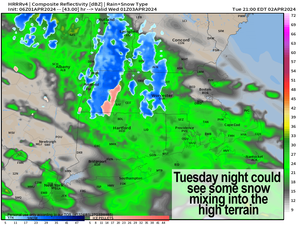
TABLE OF CONTENTS
* Daily Celestials (Sun/Moon Data)
* Morning Discussion
* TIP: Scroll below for sections, or read all
~~~~~~~~~~~~~~~~~~~~~~
YOUR DAILY CELESTIALS
~~~~~~~~~~~~~~~~~~~~~~
STAR:
–OUR STAR ROSE AT: 6:32am this morning
–OUR STAR SETS AT: 7:16pm this evening
–TOTAL DAYLIGHT TIME: 12 hours and 44 minutes
MOON:
–OUR MOON SETS AT: 10:36am this morning
–MOON SET DIRECTION: Southwest
–OUR MOON RISES AT: 3:08am tomorrow morning
–MOON RISE DIRECTION: Southeast
–MOON PHASE: Waning Gibbous (57.7%)
~~~~~~~~~~~~~~~~~~~~~~
A NOTE FROM OUR SPONSOR
~~~~~~~~~~~~~~~~~~~~~~
Dave Hayes The Weather Nut is Sponsored by Individual Community Members, Patrons, and Tandem Bagel Company… No matter the weather, Tandem Bagel is always there for you at several valley locations to make your mornings brighter! With *New Pizza Bagels(!)*, along with bagels baked fresh daily (including Gluten-Free options), house-whipped cream cheese, coffee, and tons of lunch options, Tandem is the perfect quick stop for lunch, breakfast, or a coffee and bagel to go. Find them in Easthampton, Northampton, Hadley, Florence, and West Springfield, or use their super-streamlined online ordering tool by visiting their website.
~~~~~~~~~~~~~~~~~~~~~~
YOUR MORNING DISCUSSION
~~~~~~~~~~~~~~~~~~~~~~
Good morning everybody, a very complex, multi-day, multi-precip-type, elevation-dependent late-season nor’easter will be bearing down on the greater WMass region starting tomorrow later afterenooon and lasting into early Friday morning with multiple periods of rain, sleet, snow and wind.
Was that enough hyphens for you? I’ve got more if you need ’em, on sale for today only!! #ButWaitTheresMore
For today, we have the calm before the multi-day storm, as another system is passing east off of the Mid-Atlantic coast helping to produce a gorgeous sunrise here in WMass, along with keeping it mostly cloudy today with a few showers possible in CT, though most of us stay dry.
Highs reach the low to mid 50s with southerly flow, and lows will drop into the mid to upper 30s with mostly cloudy skies tonight.
For Tuesday, our storm begins its impact in our region starting with the approach of the primary low center’s warm front.
We should stay dry in the morning as clouds thicken up, but by middle afternoon or so, first showers should be spreading northeast and into the region.
With us on the northern side of the warm front, an easterly flow off the cooler ocean will develop, and cool us into the 40s for highs, with upper 30s in the high terrain by later afternoon.
So, showers are moving into the region later Tuesday afternoon and we’re cooling down, which will continue Tuesday night as lows dip into tthe low to mid 30s, allowing for the first high-terrain snowflakes to start mixing in, and it could flip to all snow overnight in the elevated areas of the eastern and northern Berkshires, northwest hilltowns, northern CMass, SVT and SWNH, with light accumulations possible by Wednesday morning, maybe a coating up to 3″. Expect plain rain elsewhere.
By Wednesday morning, our primary low center will be directed by its upper trough over the northern Great Lakes northeastward into the Lake Erie area.
How far north the primary low is directed, will help determine how far north the secondary low center that develops Wednesday afternoon and night will track through Thursday.
Periods of rain and snow will continue on Wednesday, though it may be showery in presentation and not a more stratiform precipitation shield, the latter of which I believe moves in Wednesday evening through Thursday as the secondary low center blows up and tracks to our south near southeast MA.
Highs on Wednesday and Thursday will be colder (in the 35-40º range, with lows either side of 30º) as an east wind picks up and gusts 20-40mph at times leading to a pair of stormy, dismal, unsettled, and (for some) wintry days.
High elevation snow and sleet and low elevation rain with some sleet/snow mix will increase Wednesday afternoon as the secondary gains strength and tracks toward the NJ coast and then northeast toward Cape Cod, getting slowed down by blocking upstream, which will help the upper trough to its west to “capture” and phase with it by Thursday.
This is slows the whole operation down, which is why this is likely a multi-day event.
Heavy snow is likely in the southern Greens of SVT, and other parts of the Berkshires, WMass western hilltowns, SWNH, and northern CMass into parts of high-terrain eastern Franklin County Wednesday night into Thursday morning as the cold and precip and wind maxes, and some outages are going to be possible with that combination.
Snow may extend south into western Hampden County, southern Berkshire County and northern Litchfield County with lighter accumulations possible there as well.
The rest of the valley south and east into northerne CT and southern CMass will see mixes of rain, sleet and/or snow Wednesday night into Thursday, but unsure about minor if any accumulation.
Our storm will continue on Thursday as it wraps up near Cape Cod and pulls colder air down, possibly changing us all to periods of light snow for a time before it slowly pulls away Thursday night.
In general terms, a 6-12″ type accumulation is possible in the highest terrain with some parts of SVT going over a foot not out of the question, with lesser amounts to nothing lower down.
I will be working my butt off the next several days, as I have a long planned live music recording beginning tomorrow which concludes Wednesday evening, so at every moment I can when I am not working on that I will be working on this storm and updating you, so please send caffeine, energy drinks, match tea, medicinal mushrooms, Nodoz, whatever, and I will do my best!!!!
Have a great day!!!
P.S. Friday looks nicer, and thee weekend even more so with seasonable temps, and a decent shot at good Solar Eclipse viewing for Monday later afternoon. More on that on the other side of this early April storm!
>>> BE KIND <<<
“Hello babies. Welcome to Earth. It’s hot in the summer and cold in the winter. It’s round and wet and crowded. On the outside, babies, you’ve got a hundred years here. There’s only one rule that I know of, babies: Goddamn it, you’ve got to be kind.”
–Kurt Vonnegut