
TABLE OF CONTENTS
* Daily Celestials (Sun/Moon Data)
* Weekly Weather Nutshell
* Morning Discussion
* TIP: Scroll below for sections, or read all
~~~~~~~~~~~~~~~~~~~~~~
YOUR DAILY CELESTIALS
~~~~~~~~~~~~~~~~~~~~~~
STAR:
–OUR STAR ROSE AT: 6:33am this morning
–OUR STAR WILL SET AT: 7:15pm this evening
–TOTAL DAYLIGHT TIME: 12 hours and 42 minutes
MOON:
–OUR MOON WILL SET AT: 9:41am this morning
–MOON SET DIRECTION: Southwest
–OUR MOON WILL RISE AT: 2:14am tomorrow morning
–MOON RISE DIRECTION: Southeast
–MOON PHASE: Waning Gibbous (67.5%)
~~~~~~~~~~~~~~~~~~~~~~
>>> A NOTE FROM OUR SPONSOR <<<
Dave Hayes The Weather Nut is Sponsored by Individual Community Members, Patrons, and Gerard, Ghazey & Bates, P.C. GGBPC is a Northampton-based law firm regarded as the voice of pragmatic and well-reasoned estate planning, elder law and tax guidance in Western Massachusetts. The firm specializes in estate planning law, and expertly handles other matters such as Elder Law, Tax Law, as well as Real Estate purchase, sales, and refinance transactions. Contact GGBPC today to see how they can help!
~~~~~~~~~~~~~~~~~~~~~~
YOUR WEEKLY WEATHER NUTSHELL
~~~~~~~~~~~~~~~~~~~~~~
–Becoming mostly sunny, highs in the 50s with westerly breezes
–Tonight will see clouds increase, lows near freezing
–Tomorrow, mostly cloudy, highs 45-50º, some showers possible south of the Pike, otherwise dry
–Monday night lows drop to the mid to upper 30s with scattered showers late as a warm front approaches
–Tuesday looks like rain showers turning to or mixing with snow in the high terrain, some light accumulations possible at night
–Highs upper 30s to low 40s Tuesday, and lows in the low to mid 30s
–Highs Wednesday and Thursday 35-40º and lows in the low 30s
–Valley rain and high terrain snow possible Wednesday, with potential for snow everywhere on the greater WMass region Wednesday night into Thursday
–Easterly breezes on Tuesday back to the northeast on Wednesday into Thursday with gusts 20-40mph
–Depending on the elements referenced in the discussion below, we could see a moderate to major snowstorm develop for our high terrain areas starting Tuesday night into Wednesday, but especially Wednesday night into Thursday as colder air filters in at all levels
–Friday looks drier into next weekend
~~~~~~~~~~~~~~~~~~~~~~
YOUR MORNING DISCUSSION
~~~~~~~~~~~~~~~~~~~~~~
Good morning folks, we’ve got one more lovely day to enjoy before a stormy week looks set to unfold, so thankfully such a day is transpiring on the weekend!!
Rejoice!! Yahoo!! Woot!! Giddyup!! Yay!! Hooray!!
As much as we New Englanders grumpily grumble about the inclement weather we so often have to endure, we must also happily hoist our exalted voices to the sky in joy during the good days in equal measure!
Today is such a day with developing sunshine, downsloping west winds, and highs into the 50s, with some folks climbing up to near 60º potentially.
Lows tonight will dip into the low 30s as clouds increase due to a weak wave that will be forced to dive southeast by drier air over New England, resulting in mostly cloudy skies developing tonight into Monday over the WMass region.
While a few showers are possible in northern CT, most Monday showers should stay in southern CT and RI.
Monday’s highs climb into the 45-50º range, with lows in the mid to upper 30s as a warm front starts to extend towards our region with a few showers possible by Tuesday morning.
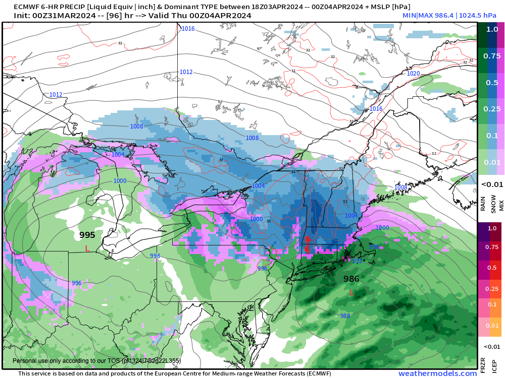
It is the Tuesday to Friday morning timeframe that I am monitoring for substantial storm potential in the form of a Miller B type setup that could bring substantial precipitation in the form of rain and accumulating snow, along with gusty winds and scattered power outages where and if parameters align.
On Tuesday, we’re mainly under the influence of a warm front extending toward the region, and as of now, likely remaining south of us, keeping us on its cooler side.
This will push areas of scattered showers east into our region as early as Tuesday morning. Highs will climb into the upper 30s to mid 40s, and some snow may start mixing in over the high terrain of northwest MA and southern VT by afternoon or evening.
Meanwhile, a primary low center will be pushing through Ohio and toward western NY and northwest PA.
There may be a lull between warm frontal showers and the influence of our primary low, but mixed showers should continue Tuesday night with lows in the low to mid 30s.
It is the Wednesday to Thursday timeframe that I expect the most substantial storminess will occur, as it is on Wednesday that we start to see our “atmospheric traffic” get blocked up, and slowed down.
This blocking will occur due initially to a retrograding upper trough well east of us over eastern Newfoundland, Canada that gives way to the potential meteorological joinder of an upper ridge over Quebec down through eastern Nova Scotia — upper level steering features due east of us that will cause the primary low to slow down over the eastern Great Lakes on Wednesday and help spawn a strengthening secondary low which will track off of the NJ coast and into or south of southern New England.
As this occurs, two things will probably happen. One, we’ll see colder air get drawn south as easterly flow turns more northeasterly toward the developing secondary, and Two, we’ll see an upper trough swing into the Great Lakes and help develop the secondary low, and potentially capture it, stack on top of it, and slow it down even more, somewhere near southeast MA by late Wednesday night into Thursday.
This could help rain on Wednesday be flipped to wet snow in the high terrain at least, and by Wednesday evening and night, possibly into the valley as well.
This would likely produce a more wintry result for Thursday and Thursday evening, if a stalled bombing low is sitting off of Cape Cod, but these storm systems are complicated, and we’re days away.
Lots of changes can happen, but this could produce a moderate to heavy late-season snowstorm for our high terrain areas in WMass, CMass, SVT and SWNH with plows out, and power out given that a potent low to our east would produce high terrain wind gusts of up to 40mph possibly.
Northern CT will be trickier in terms of precip types, but some snow is possible down that way, too.
Regardless of precip type, this looks like a juicy system with 1-3″ of liquid equivalent.
I will stay on top of it and provide updates as we get closer.
But for today, enjoy every minute of it!
>>> BE KIND <<<
“Hello babies. Welcome to Earth. It’s hot in the summer and cold in the winter. It’s round and wet and crowded. On the outside, babies, you’ve got a hundred years here. There’s only one rule that I know of, babies: Goddamn it, you’ve got to be kind.”
–Kurt Vonnegut