
~~~~~~~~~~~~~~~~~~~~~~
TABLE OF CONTENTS
* Daily Celestials (Sun/Moon Data)
* Weekly Weather Nutshell
* Morning Discussion
* TIP: Scroll below for sections, or read all
~~~~~~~~~~~~~~~~~~~~~~
YOUR DAILY CELESTIALS
~~~~~~~~~~~~~~~~~~~~~~
STAR:
–OUR STAR ROSE AT: 5:55am this morning
–OUR STAR SETS AT: 7:42pm this evening
–TOTAL DAYLIGHT TIME: 13 hours and 47 minutes
MOON:
–OUR MOON RISES AT: 8:46pm this evening
–MOON RISE DIRECTION: East-Southeast
–OUR MOON SETS AT: 6:26am tomorrow morning
–MOON SET DIRECTION: West-Southwest
–MOON PHASE: Waning Gibbous (99.8%)
~~~~~~~~~~~~~~~~~~~~~~
A NOTE FROM OUR SPONSOR
~~~~~~~~~~~~~~~~~~~~~~
Dave Hayes The Weather Nut is Sponsored by Individual Community Members, Patrons, and Tandem Bagel Company… No matter the weather, Tandem Bagel is always there for you at several valley locations to make your mornings brighter! With *New Pizza Bagels(!)*, along with bagels baked fresh daily (including Gluten-Free options), house-whipped cream cheese, coffee, and tons of lunch options, Tandem is the perfect quick stop for lunch, breakfast, or a coffee and bagel to go. Find them in Easthampton, Northampton, Hadley, Florence, and West Springfield, or use their super-streamlined online ordering tool by visiting their website.
~~~~~~~~~~~~~~~~~~~~~~
YOUR WEEKLY WEATHER NUTSHELL
~~~~~~~~~~~~~~~~~~~~~~
–Still fairly dry and mild this morning, temps in the 40s
–A few morning scattered showers are expected, but many stay dry
–Highs reach the 50s today
–By early to mid afternoon some isolated showers and thunderstorms develop interspersed some sunny breaks/periods
–A few higher briefly higher gusts are possible
–The cold front passes by mid/late afternoon, and northwest gusts develop 15-25mph or so at times
–Skies will clear this evening and overnight, and gusts will slacken sometime after midnight
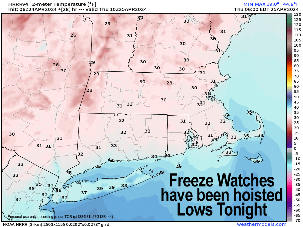
–Between mixing colder aloft to the surface and pre-dawn radiational cooling after the wind dies out, temps are likely plummeting deep into the 20s overnight
–Some upper teens are possible in SVT or SWNH
–Thursday is a sunny, cool day with highs in the upper 40s to mid 50s as high pressure starts to spill southeast from Canada
–Thursday night features only radiational cooling, and temps again drop into the 20s with more Freeze Watches likely
–Friday sees more sun, highs mid 50s to low 60s, with lows near freezing for one last frosty night
–Saturday represents a shift towards the first deeper Spring surge coming up early next week
–We start out partly sunny, then cloud up by afternoon with a warm front moving in
–Highs again in the mid 50s to low 60s
–Showers move in Saturday night into early Sunday, then temps soar into the mid 60s to low 70s Sunday with clouds and some late day sunny breaks
–By Monday we’re well into the 70s under partly sunny skies with southwest flow
–A few more showers are possible by Tuesday with a frontal boundary
~~~~~~~~~~~~~~~~~~~~~~
YOUR MORNING DISCUSSION
~~~~~~~~~~~~~~~~~~~~~~
Good morning folks, it certainly is a lot milder this morning as southerly flow developed overnight ahead of our incoming cold front.
I’m trying to start my days by going outside and getting my bare feet on the ground to connect with the planet, and my feets felt the mildening compared to the previous morning!
I probably won’t make it long early tomorrow morning, that’s for sure, as a string of unseasonably cold nights are on the way, with the next two providing hard freeze potential.
For today, our highs will climb into the 50s, and a cold front will approach the region and pass through by mid to late afternoon.
A few morning showers are possible, and then we should see skies brighten by afternoon with some sunny breaks and isolated to widely scattered showers or a thunderstorm moves through between say 1-5pm northwest to southeast.
Behind the cold front, northwest winds will gust 15-25mph very late this afternoon and through the first part of tonight, possibly reaching 30mph in spots.
As skies clear, we’ll start off breezy, but after midnight winds should come down. With cold air aloft, the windy part of the evening mixes that colder air down, and during calmer part toward dawn, radiational cooling should take over.
The combination should plummet temps well into the 20s overnight and possibly upper teens in a few spots north of the Rt. 2 corridor.
This is obviously bad for fruit trees and other tender veg any early planters may have outside, so protect your plants people, the best you can.
Thursday and Friday are a pair of twin days as high pressure settles southeast, with mostly sunny skies and highs in the mid 50s to low 60s, with another freeze possible tomorrow night with lows in the 20s, and then a frosty Friday night as well with lows near freezing.
By Saturday, we start off partly sunny, and finish cloudy with highs either side of 60º as a warm front approaches, bringing some showers Saturday night into very early Sunday morning.
Southwest flow gets shoved into the region thanks to that high pressure system now residing to our south (air flows clockwise around high pressure), and highs should respond, rising into the mid 60s to low 70s with some afternoon sunny breaks.
By Monday? We’re into the 70s, and someone could hit 80º in the Springfield to Hartford stretch!
More showers arrive by Tuesday, and how that front sets up will help dictate temps for the rest of next week, but I’ll sort that out as we get closer.
From 20º late tonight to 80º next Monday, New England weather is rarely ever boring!
Have a great day!
>>> BE KIND <<<
“Hello babies. Welcome to Earth. It’s hot in the summer and cold in the winter. It’s round and wet and crowded. On the outside, babies, you’ve got a hundred years here. There’s only one rule that I know of, babies: Goddamn it, you’ve got to be kind.”
–Kurt Vonnegut