
~~~~~~~~~~~~~~~~~~~~~~
TABLE OF CONTENTS
* Daily Celestials (Sun/Moon Data)
* Weekly Weather Nutshell
* Morning Discussion
* TIP: Scroll below for sections, or read all
~~~~~~~~~~~~~~~~~~~~~~
YOUR DAILY CELESTIALS
~~~~~~~~~~~~~~~~~~~~~~
STAR:
–OUR STAR ROSE AT: 5:58am this morning
–OUR STAR SETS AT: 7:40pm this evening
–TOTAL DAYLIGHT TIME: 13 hours and 42 minutes
MOON:
–OUR MOON RISES AT: 6:36pm this afternoon
–MOON RISE DIRECTION: East-Southeast
–OUR MOON SETS AT: 5:39am tomorrow morning
–MOON SET DIRECTION: West-Southwest
–MOON PHASE: Waxing Gibbous 97.8%
~~~~~~~~~~~~~~~~~~~~~~
A NOTE FROM OUR SPONSOR
~~~~~~~~~~~~~~~~~~~~~~
Dave Hayes The Weather Nut is Sponsored by Individual Community Members, Patrons, and Tandem Bagel Company… No matter the weather, Tandem Bagel is always there for you at several valley locations to make your mornings brighter! With *New Pizza Bagels(!)*, along with bagels baked fresh daily (including Gluten-Free options), house-whipped cream cheese, coffee, and tons of lunch options, Tandem is the perfect quick stop for lunch, breakfast, or a coffee and bagel to go. Find them in Easthampton, Northampton, Hadley, Florence, and West Springfield, or use their super-streamlined online ordering tool by visiting their website.
~~~~~~~~~~~~~~~~~~~~~~
YOUR WEEKLY WEATHER NUTSHELL
~~~~~~~~~~~~~~~~~~~~~~
–High pressure brings sunshine for today and Tuesday
–Highs reach the mid to upper 50s today, and low to mid 60s tomorrow
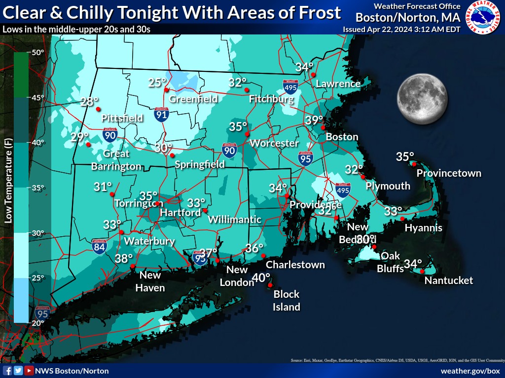
–Lows are in the 20s and 30s this morning, and will dip into the mid 20s to mid 30s tomorrow morning, and possibly the low 20s in southern VT!
–Frost Advisories are up for northern CT tonight
–Northwest winds may gust to 20mph for some today, especially north of Rt. 2, where enhanced risk of fire spread exists
–By late Tuesday clouds will increase, and as a cold front presses toward the region, showers should break out in the pre-dawn Wednesday morning hours
–Some cold air aloft will be working into the region Wednesday, and this could help foster convection
–This means thunderstorms are possible, with gusty winds accompanying some cells
–Highs will reach the 55-60º range, with night time clearing and lows in the upper 20s to low 30s with patchy frost
–Thursday looks breezy behind the front, as high pressure pushes into the region
–A 3-day sunny stretch is expected Thursday through Saturday with highs in the mid to upper 50s Thursday, low 60s by Friday, and mid 60s by Saturday
–More frost is possible Friday morning
–More showers are possible Sunday as another frontal boundary moves into the region
–No washouts are on the horizon, though if thunderstorms do form on Wednesday, localized and narrow strips of terrain could see heavier rain
~~~~~~~~~~~~~~~~~~~~~~
YOUR MORNING DISCUSSION
~~~~~~~~~~~~~~~~~~~~~~
Good morning folks, I am happy to announce that in the next 6 days we will have 5 dry and mostly sunny days to enjoy, including this coming Saturday (as it looks now) which will likely be next weekend’s pick for outdoor activities.
Again, while it will breezy at times this week, and mostly dry except for Wednesday, there will be a chance for any burns to spread due to low humidity and drying soils.
However, the main story this week is the chance for frost over multiple mornings, including today, but especially so for tomorrow morning when lows should dip into the mid 20s in spots.
High pressure dominates today and tomorrow with mild days and cold nights, and then we cloud up Tuesday night with showers coming into our western areas around midnight or so, and lasting into at least early afternoon on Wednesday, with a soggy morning commute expected.
There’s also a chance for thunderstorms on Wednesday due to the potential for two upper level systems interacting, and helping to pull colder air in aloft which would allow faster rising air (i.e. “convection”) which could spawn some storms with gusty winds or small hail or graupel.
This clears out rapidly Wednesday evening and night, with temps dropping into the upper 20s to low 30s with more potential for frost, despite some expected breezy conditions.
Abundant sunshine returns Thursday through Saturday with breezy conditions early in that period, and warming temps into the weekend.
By Sunday, another frontal boundary should be nearby with potential for more showers, and this may last into next Monday, but for now, let’s just rejoice in the abundant sunshine and dry weather for which so many of us have been pining for months now!
Have a great day!
>>> BE KIND <<<
“Hello babies. Welcome to Earth. It’s hot in the summer and cold in the winter. It’s round and wet and crowded. On the outside, babies, you’ve got a hundred years here. There’s only one rule that I know of, babies: Goddamn it, you’ve got to be kind.”
–Kurt Vonnegut