
~~~~~~~~~~~~~~~~~~~~~~
TABLE OF CONTENTS
* Daily Celestials (Sun/Moon Data)
* Weekly Weather Nutshell
* Morning Discussion
* TIP: Scroll below for sections, or read all
~~~~~~~~~~~~~~~~~~~~~~
YOUR DAILY CELESTIALS
~~~~~~~~~~~~~~~~~~~~~~
STAR:
–OUR STAR ROSE AT: 6:02am this morning
–OUR STAR SETS AT: 7:36pm this evening
–TOTAL DAYLIGHT TIME: 13 hours and 34 minutes
MOON:
–OUR MOON RISES AT: 3:32pm this afternoon
–MOON RISE DIRECTION: East-Northeast
–OUR MOON SETS AT: 4:44am tomorrow morning
–MOON SET DIRECTION: West
–MOON PHASE: Waxing Gibbous 82.4%
~~~~~~~~~~~~~~~~~~~~~~
A NOTE FROM OUR SPONSOR
~~~~~~~~~~~~~~~~~~~~~~
Dave Hayes The Weather Nut is Sponsored by Individual Community Members, Patrons, and Tandem Bagel Company… No matter the weather, Tandem Bagel is always there for you at several valley locations to make your mornings brighter! With *New Pizza Bagels(!)*, along with bagels baked fresh daily (including Gluten-Free options), house-whipped cream cheese, coffee, and tons of lunch options, Tandem is the perfect quick stop for lunch, breakfast, or a coffee and bagel to go. Find them in Easthampton, Northampton, Hadley, Florence, and West Springfield, or use their super-streamlined online ordering tool by visiting their website.
~~~~~~~~~~~~~~~~~~~~~~
YOUR WEEKLY WEATHER NUTSHELL
~~~~~~~~~~~~~~~~~~~~~~
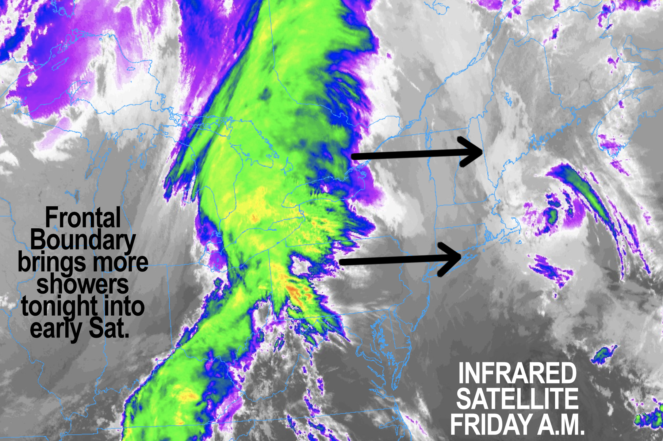
–A cold front is incoming, and despite some sunny breaks/periods at times, we’ll be mostly cloudy on average today
–Highs should reach the mid 50s to low 60s with a light southeast wind
–Clouds thicken later today, and rain showers should arrive by very late afternoon into early evening
–Showers will pick up in intensity after midnight, and it could rain heavily at times toward and just after dawn
–Lows will dip into the low to mid 40s, and some patchy fog is possible
–Saturday morning will feature showers lasting likely until at least mid-morning, and possibly later morning east of I-91
–By afternoon, we should break into a partly sunny day on average, but I can’t rule out additional clouds building with a few spot showers possible in the afternoon
–Highs in the mid 50s to low 60s, and lows drop to the low to mid 30s with clearing skies, patchy frost in the Berkshires possible
–Sunday through Tuesday looks like a period dominated by high pressure with mostly sunny skies, mild days in thee 50s to low 60s, and cool nights in the low to mid 30s
–It looks breezy as well, which means fire could spread more easily as surfaces continue to dry out
–Tuesday morning may feature patchy frost even into parts of the Pioneer Valley
–After a sunny Tuesday, clouds will build toward evening west of the I-91 corridor, and showers are expected for Wednesday as a frontal boundary comes through the region
–It will be a bit cooler with highs in the mid 50s
–Behind that front, we get a legit cool shot, it is Thursday morning when frost could be widespread with lows in the upper 20s to low 30s, so heads up plant people
–A cooler, fair weather day with breezy conditions arrives for Thursday with highs either side of 50º
~~~~~~~~~~~~~~~~~~~~~~
YOUR MORNING DISCUSSION
~~~~~~~~~~~~~~~~~~~~~~
Good morning folks, the Nutshell will take you through the upcoming weather details of which we should be aware, but the bottom line is that we only have two periods of showers to contend with over the next 7 days, and that is tonight into Saturday morning, and again on Wednesday.
The trend for tonight’s/tomorrow’s system has been to become a bit more robust, especially during early Saturday morning, so I am expecting some heavier rain showers at times, and a rumble of thunder can’t be ruled out either as the front passes through.
This trend is also a temporal one, meaning that while Saturday was looking quite nice up until recently, the first half of the day looks showery to cloudy, with partial sun in the afternoon.
Even then we could have cloudier periods or a spot shower or two as cooler air works in aloft ahead of incoming high pressure for the Sunday through Tuesday period.
Sunday is DEFINITELY the pick of the weekend with plenty of sunshine, and it also looks breezy into early next week, with some cold nights upcoming as well.
In particular, Tuesday morning and Thursday morning (even more so) look cold with potential for patchy frost early Tuesday with widespread frost potential for Thursday morning, so heads up to those with gardening/farming interests.
Again, Wednesday is our next showery period, but it doesn’t look like a washout, and the potential is there for cooler but drier conditions to last for a few days into next weekend, so here’s hoping that trend holds!
Have a great day!
>>> BE KIND <<<
“Hello babies. Welcome to Earth. It’s hot in the summer and cold in the winter. It’s round and wet and crowded. On the outside, babies, you’ve got a hundred years here. There’s only one rule that I know of, babies: Goddamn it, you’ve got to be kind.”
–Kurt Vonnegut