
~~~~~~~~~~~~~~~~~~~~~~
TABLE OF CONTENTS
* Daily Celestials (Sun/Moon Data)
* Weekly Weather Nutshell
* Morning Discussion
* TIP: Scroll below for sections, or read all
~~~~~~~~~~~~~~~~~~~~~~
YOUR DAILY CELESTIALS
~~~~~~~~~~~~~~~~~~~~~~
STAR:
–OUR STAR ROSE AT: 6:04am this morning
–OUR STAR SETS AT: 7:35pm this evening
–TOTAL DAYLIGHT TIME: 13 hours and 31 minutes
MOON:
–OUR MOON RISES AT: 2:30pm this afternoon
–MOON RISE DIRECTION: East-Northeast
–OUR MOON SETS AT: 4:26am tomorrow morning
–MOON SET DIRECTION: West-Northwest
–MOON PHASE: Waxing Gibbous 74.6%
~~~~~~~~~~~~~~~~~~~~~~
A NOTE FROM OUR SPONSOR
~~~~~~~~~~~~~~~~~~~~~~
Dave Hayes The Weather Nut is Sponsored by Individual Community Members, Patrons, and Tandem Bagel Company… No matter the weather, Tandem Bagel is always there for you at several valley locations to make your mornings brighter! With *New Pizza Bagels(!)*, along with bagels baked fresh daily (including Gluten-Free options), house-whipped cream cheese, coffee, and tons of lunch options, Tandem is the perfect quick stop for lunch, breakfast, or a coffee and bagel to go. Find them in Easthampton, Northampton, Hadley, Florence, and West Springfield, or use their super-streamlined online ordering tool by visiting their website.
~~~~~~~~~~~~~~~~~~~~~~
YOUR WEEKLY WEATHER NUTSHELL
~~~~~~~~~~~~~~~~~~~~~~
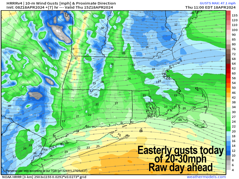
–Low pressure to our northwest and a warm front combine to produce scattered showers over western parts of our region today
–Generally showers should stay west of a line from Keene, NH to Worcester MA to Providence RI, with little activity to the east of that line
–Highs will remain in the 40s today, with easterly gusts of 20-30mph so a raw day lies ahead
–Some heavier showers this morning in the Berkshires, northwest CT and into parts of the CT River Valley
–Showers abate tonight with lows either side of 40º
–A partly sunny Friday develops before a cold front moves through with showers in the evening and overnight
–Highs are milder, reaching the mid to upper 50s, with lows in the low to mid 40s
–Saturday and Sunday will combine to form a very nice weekend with highs Saturday in the upper 50s to mid 60s, and more firmly in the 50s to low 60s on Sunday, which appropriately looks sunnier
–Lows both nights will dip to the mid to upper 30s under partly cloudy skies
–Both days look breezy, and there continues to be somoe concern for fire spread conditions
–Monday and Tuesday feature high pressure building into the south of our region
–This should lessen windy conditions, turn our wind from the west to the south, and provide sunshine with highs in the upper 50s to mid 60s
–By mid week another frontal boundary from another storm passing to our north should bring more showers to the region, but it doesn’t look like a big deal right now
~~~~~~~~~~~~~~~~~~~~~~
YOUR MORNING DISCUSSION
~~~~~~~~~~~~~~~~~~~~~~
Good morning folks, we have a raw day ahead with highs in the 40s, east winds gusting 20-30mph off the ocean, and periods of rain showers, especially in WMass, north-central and northwest CT and SVT into the Taconics.
Areas more east of there into CMass should still see some showers, but lighter and less frequency.
The heaviest rain is falling this morning overe the Berkshires, Litchfield County CT and the southwest hilltowns in Hampden and Hampshire Counties.
As a warm front comes into the region, it is met with a drier push of easterly air from high pressure over Quebec, which is why it’s drier in eastern areas, with rain evaporating or decreasing in intensity as it tracks east.
For tonight, any showers will end and lows will fall into the upper 30s to low 40s, leading to a partly sunny start to our Friday.
Highs will come up into the 50s tomorrow and while we’ll get some sun earlier on, clouds will build in the afternoon as another frontal boundary approaches from the west, draped off of a storm to our north that will track into southeast Canada.
Scattered showers will move back into the region by evening and into the night time, but should not amount to much, and less than what we experienced overnight and into today (especially over the Berkshires and Litchfields which got over half an inch in spots, more than expected).
Lows Friday night will drop to the low to mid 40s, and showers should clear out of here during the pre-dawn hours of Saturday morning.
Our upcoming weekend looks lovely, though a bit breezy, but milder with highs in the upper 50s to mid 60s Saturday, and 50s to near or at 60º on Sunday with increasing sunshine through the weekend (a bit more clouds on Saturday compared to Sunday, which looks mostly sunny).
Depending on how breezy it gets and how quickly it dries out, increased risk of fire spread is a possibility, so keep that in mind.
Lows will be chilly, dipping into the mid to upper 30s both nights.
Monday and Tuesday continue the streak of fair weather with mild highs in the upper 50s to mid 60s, sunshine, and lighter winds as high pressure passes to our southwest and south.
By Wednesday, a trough will push into the Great Lakes region with surface low pressure passing to our north, which should drag another frontal boundary through the region with a period of showers, but it doesn’t look like a big deal for now, and even though some guidance is signaling a change to snow as the front moves through, it’s highly doubtful that it will transpire given that we’re in late April.
Have a great day and stay warm!
>>> BE KIND <<<
“Hello babies. Welcome to Earth. It’s hot in the summer and cold in the winter. It’s round and wet and crowded. On the outside, babies, you’ve got a hundred years here. There’s only one rule that I know of, babies: Goddamn it, you’ve got to be kind.”
–Kurt Vonnegut