
TABLE OF CONTENTS
* Daily Celestials (Sun/Moon Data)
* Weekly Weather Nutshell
* Morning Discussion
* TIP: Scroll below for sections, or read all
~~~~~~~~~~~~~~~~~~~~~~
YOUR DAILY CELESTIALS
~~~~~~~~~~~~~~~~~~~~~~
STAR:
–OUR STAR ROSE AT: 6:05am this morning
–OUR STAR SETS AT: 7:34pm this evening
–TOTAL DAYLIGHT TIME: 13 hours and 29 minutes
MOON:
–OUR MOON RISES AT: 1:27pm this afternoon
–MOON RISE DIRECTION: East-Northeast
–OUR MOON SETS AT: 4:05am tomorrow morning
–MOON SET DIRECTION: West-Northwest
–MOON PHASE: Waxing Gibbous 65.9%
~~~~~~~~~~~~~~~~~~~~~~
A NOTE FROM OUR SPONSOR
~~~~~~~~~~~~~~~~~~~~~~
Dave Hayes The Weather Nut is Sponsored by Individual Community Members, Patrons, and Tandem Bagel Company… No matter the weather, Tandem Bagel is always there for you at several valley locations to make your mornings brighter! With *New Pizza Bagels(!)*, along with bagels baked fresh daily (including Gluten-Free options), house-whipped cream cheese, coffee, and tons of lunch options, Tandem is the perfect quick stop for lunch, breakfast, or a coffee and bagel to go. Find them in Easthampton, Northampton, Hadley, Florence, and West Springfield, or use their super-streamlined online ordering tool by visiting their website.
~~~~~~~~~~~~~~~~~~~~~~
YOUR WEEKLY WEATHER NUTSHELL
~~~~~~~~~~~~~~~~~~~~~~
–Mostly sunny and dry start to our Wednesday
–High visibility, light wind, and temps in the 30s and 40s this morning, with a few upper 20s
–Highs climb to the low to mid 60s
–Clouds build this afternoon
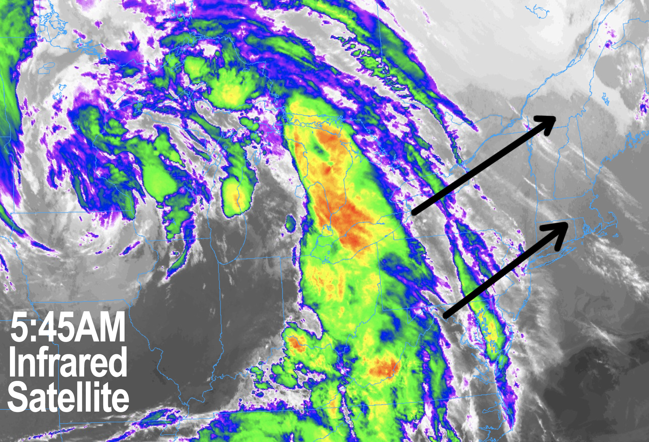
–A warm front pushes toward the region this evening
–Showers develop likely before midnight in the Berkshires Region and spread east-northeast overnight
–Lows drop into the low to mid 40s, with highs tomorrow in the mid 40s to low 50s (the coolest day of the next 7)
–Thursday looks showery, but showers should be on the lighter side
–High pressure to our east dries out the eastern part of the precip shield, so eastern SWNH, CMass and northeast CT should see less rain (either side of a tenth of an inch) vs. SVT, WMass and northwest CT (either side of a quarter of an inch)
–Showers last through Thursday and end as patchy drizzle Thursday night with lows in the upper 30s to low 40s
–Friday looks dry, but mostly cloudy as high pressure nudges in for a day, ahead of an incoming cold front that won’t have much oomph with it
–Highs will come up well into the 50s, and clouds will thicken in the afternoon with light scattered showers pushing into the region by dinner time
–Light showers are expected Friday night with lows in the low to mid 40s as a system passes to our north into southeast Canada by Saturday
–Any early morning Saturday showers should dissipate with drier air moving in for the weekend, hooray!
–Sunday looks to be the sunnier of the two days, but a touch cooler with highs in the 50s vs. mid 50s to low 60s on Saturday under partly sunny skies
–A westerly breeze with gusts up to 25mph looks probable for both days, especially Saturday
–Lows look chilly in the 30s for both weekend nights
–Early next week looks lovely as well, with highs in the mid 50s to low 60s Monday and Tuesday, with lows in the 35-40º range with fair weather expected
–The next chance for showers is mid to late next week but much uncertainty remains, so for now let’s appreciate that we’re likely to get a 4-day partly to mostly sunny stretch Saturday through Tuesday, with a total of either side of half an inch of rain between tomorrow and Friday night, which is tolerable compared to recent weeks
~~~~~~~~~~~~~~~~~~~~~~
YOUR MORNING DISCUSSION
~~~~~~~~~~~~~~~~~~~~~~
Good morning everybody, aside from scattered showers due to a couple of frontal passages tonight/Thursday and again Friday night, we are going to experience way more dry days than wet through next Tuesday at least.
While the shower activity tonight through tomorrow and again Friday late afternoon into very early Saturday morning will be tolerable, there is a slight concern for easier fire spread this weekend as we dry out and maintain some breezy conditions, so just be a bit mindful of any outdoor burns.
Otherwise, the Nutshell will run you through the day to day details, as there isn’t much going on that’s worth a long form discussion.
High pressure today, a warm front tonight and tomorrow with showers, high pressure Friday, a cold front Friday night that clears the region by the weekend with even higher pressures into early next week, along with seasonable temps for the most part, after an above average day today.
What’s not to love?
I’m sure someone will find something ;-)
Have a great day!
>>> BE KIND <<<
“Hello babies. Welcome to Earth. It’s hot in the summer and cold in the winter. It’s round and wet and crowded. On the outside, babies, you’ve got a hundred years here. There’s only one rule that I know of, babies: Goddamn it, you’ve got to be kind.”
–Kurt Vonnegut