
TABLE OF CONTENTS
* Daily Celestials (Sun/Moon Data)
* Weekly Weather Nutshell
* Morning Discussion
* TIP: Scroll below for sections, or read all
~~~~~~~~~~~~~~~~~~~~~~
YOUR DAILY CELESTIALS
~~~~~~~~~~~~~~~~~~~~~~
STAR:
–OUR STAR ROSE AT: 6:12am this morning
–OUR STAR WILL SET AT: 7:30pm this evening
–TOTAL DAYLIGHT TIME: 13 hours and 18 minutes
MOON:
–OUR MOON WILL RISE AT: 9:13am this morning
–MOON RISE DIRECTION: Northeast
–OUR MOON WILL SET AT: 1:45am tomorrow morning
–MOON SET DIRECTION: Northwest
–MOON PHASE: Waxing Crescent (27.3%)
~~~~~~~~~~~~~~~~~~~~~~
>>> A NOTE FROM OUR SPONSOR <<<
Dave Hayes The Weather Nut is Sponsored by Individual Community Members, Patrons, and Gerard, Ghazey & Bates, P.C. GGBPC is a Northampton-based law firm regarded as the voice of pragmatic and well-reasoned estate planning, elder law and tax guidance in Western Massachusetts. The firm specializes in estate planning law, and expertly handles other matters such as Elder Law, Tax Law, as well as Real Estate purchase, sales, and refinance transactions. Contact GGBPC today to see how they can help!
~~~~~~~~~~~~~~~~~~~~~~
YOUR WEEKLY WEATHER NUTSHELL
~~~~~~~~~~~~~~~~~~~~~~
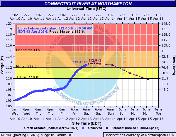
–The CT River is in flood at Northampton cresting to 112.8 feet by early afternoon, so areas around The Oxbow, low-lying Hatfield areas and others will see flooding
–The CT River is in flood at Hartford and will crest to 20.5 feet from noon to midnight tomorrow
–Temps are in the mid/upper 30s over the western high terrain and 40s elsewhere doesn’t move much today
–Clouds continue to fill in as our upper low swings into the greater WMass region with broad/moderate lift
–Scattered instability showers develop into the afternoon, generally oon the lighter side
–This forms into a brief upsloping precip period into this evening with rain and snow showers over the Berkshires, western hilltowns, northern Litchfields, Taconics and southern Greens
–Winds will kick up as colder air moves overhead and lapse rates steepen (larger gradient of milder surface / colder aloft)
–Gusts of 30-50mph are expected as a blustery, cooler afternoon and evening develops
–Lows will drop into the 30s as we dry out and the upper low lifts northeast and away, winds should slacken by Sunday morning
–A lovely Sunday morning develops with party to mostly sunny skies, and high temps should crest well into the 50s
–However, clouds will develop toward mid-day, and a quick-moving system will dive southeast through New England and push more showers into the region by mid to especially later afternoon and evening
–In fact, I can’t rule out some thunder along or especially south of the Pike into northern CT
–Lows drop to either side of 40º, and we’ll clear out late
–Monday and Tuesday look lovely as high pressure builds into the region, impacting our sensible weather thru Wed A.M.
–Mostly sunny days for Monday and Tuesday will bring temps up into the 60s, and possibly low 70s by Tuesday, with lows in the 40s
–Thereafter, we do likely see another storm crank up over the western Ohio Valley and Great Lakes region
–This would extend another warm front towards our region and push showers back in by Wednesday afternoon or evening into Thursday
–A couple of waves of low pressure may extend showery conditions into Thursday and Thursday night before a brief break on Friday
–The storm signal has tamped down a bit for next weekend, but showers are still possible with mild temps in the 50s for highs
~~~~~~~~~~~~~~~~~~~~~~
YOUR MORNING DISCUSSION
~~~~~~~~~~~~~~~~~~~~~~
Good morning folks, the Nutshell is going to provide you with endless amounts of weather wonderment for this morning’s meteorological update, but the bottom line is that while we get some sunny breaks early today, clouds will build as a southeastward-extending upper low nub noses into our region today with more clouds, scattered instability showers, a bit of snow in the high terrain (can’t rule out a fresh wet snow inch over the high southern Greens of VT by tonight), and windy conditions by afternoon and evening with gusts 30-50mph for a blustery finish.
Sunday starts off with a morning of sun, and finishes with showers into the evening, with thunder possible in southern areas before we land into a glorious two-day sunny and warm period for Monday and Tuesday, prior to more mid-week showers.
Watch for flooded areas near The Oxbow in Northampton, as well low lying Hatfield areas as the CT River will crest to 112.8 feet by 1pm today (flood stage is 112 feet).
As always, I’m visioning a much drier period for later April into May, so we drain waterways and surface soils. Here’s hoping.
Have a great day, we’re alive today if we’re reading this! Raise the ‘brows and put on a slight smile for 10 seconds – the brain likes it!
>>> BE KIND <<<
“Hello babies. Welcome to Earth. It’s hot in the summer and cold in the winter. It’s round and wet and crowded. On the outside, babies, you’ve got a hundred years here. There’s only one rule that I know of, babies: Goddamn it, you’ve got to be kind.”
–Kurt Vonnegut