
TABLE OF CONTENTS
* Daily Celestials (Sun/Moon Data)
* Weekly Weather Nutshell
* Morning Discussion
* TIP: Scroll below for sections, or read all
~~~~~~~~~~~~~~~~~~~~~~
YOUR DAILY CELESTIALS
~~~~~~~~~~~~~~~~~~~~~~
STAR:
–OUR STAR ROSE AT: 6:13am this morning
–OUR STAR SETS AT: 7:28pm this evening
–TOTAL DAYLIGHT TIME: 13 hours and 15 minutes
MOON:
–OUR MOON RISES AT: 8:23am this morning
–MOON RISE DIRECTION: Northeast
–OUR MOON SETS AT: 12:44am tomorrow morning
–MOON SET DIRECTION: Northwest
–MOON PHASE: Waxing Crescent (17.5%)
~~~~~~~~~~~~~~~~~~~~~~
A NOTE FROM OUR SPONSOR
~~~~~~~~~~~~~~~~~~~~~~
Dave Hayes The Weather Nut is Sponsored by Individual Community Members, Patrons, and Tandem Bagel Company… No matter the weather, Tandem Bagel is always there for you at several valley locations to make your mornings brighter! With *New Pizza Bagels(!)*, along with bagels baked fresh daily (including Gluten-Free options), house-whipped cream cheese, coffee, and tons of lunch options, Tandem is the perfect quick stop for lunch, breakfast, or a coffee and bagel to go. Find them in Easthampton, Northampton, Hadley, Florence, and West Springfield, or use their super-streamlined online ordering tool by visiting their website.
~~~~~~~~~~~~~~~~~~~~~~
YOUR WEEKLY WEATHER NUTSHELL
~~~~~~~~~~~~~~~~~~~~~~
–Rain continues this morning, heavy at times
–Thunderstorms possible east of I-91 after 7am
–Patchy fog/drizzle as well, with mild temps either side of 60º
–Humid, and gusty at times with southerly gusts of 20-40mph possible, especially at elevation
–Toward mid day showers should weaken considerably with a few isolated showers left
–However, by mid to late afternoon another round comes in with the cold frontal passage, could be heavy
–High temps are pretty much where they are now, but should climb a few more degrees into the low to mid 60s
–Winds shift around to the southwest this evening and into tomorrow, gusting 20-35mph at times
–Lows tonight dip into the low to mid 40s with a few scattered showers possible into Saturday morning before better drying by afternoon
–Highs only reach the mid 40s to low 50s, and it will be blustery and cool under mostly cloudy skies
–We’ll get a few breaks in the cloud deck by Saturday night with lows in the mid 30s to low 40s
–Then temps come up with warmer westerly flow, with highs reaching the mid 50s to low 60s under partly sunny skies early
–However, clouds build by mid day or so, with a period of showers tracking through the region from west to east later Sunday afternoon and evening with lows in the low/mid 40s
–High pressure builds into the region Monday and Tuesday with mostly sunny skies and highs in the low to mid 60s Mon, and mid to upper 60s Tues with lows in the 40s
–By later Wednesday into Thursday we could see more showers, and there’s a stronger rain signal for next weekend
~~~~~~~~~~~~~~~~~~~~~~
YOUR MORNING DISCUSSION
~~~~~~~~~~~~~~~~~~~~~~
Good morning everybody, we’ve had a thunderstorm run up the Pioneer Valley from the south earlier, and I am tracking additional downpours capable of producing thunderstorms that will likely pass east of the I-91 corridor through eastern parts of WMass and CMass as well as north-central and northeast CT around or after 7am.
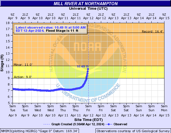
Another slug of heavier showers will also pass through much of WMass, and this will help push the Mill River at Florence into minor flood, so folks along Meadow Street, as well as other areas of the Mill River including the Smith Riverwalk and The Oxbow need to be aware of flood potential this morning as a Flood Warning is in place for central Hampshire County down into north-central Hampden County.
Showers will tamp down by mid-day, but another round will move thru by mid to late afternoon with the cold front, which will also switch our winds around to the southwest and west, gusting 20-35mph at times tonight into Saturday, which looks cooler and blustery.
We still can’t rule out a few scattered showers overnight tonight and into Saturday morning, with a few snowflakes mixing into the highest mountains in our region before we dry out for the afternoon and night.
Dry weather continues into the first part of Sunday with a partly sunny start and milder temps, but a weak wave will be passing through northern New England Sunday night, and will cloud us over by afternoon.
Then a period of scattered showers moves through the region by Sunday evening and overnight.
Behind this system, we’ll drag warmer air into our region, as well as an area of high pressure that will provide a much needed two-day sunny period with highs in the 60s to near 70º by Tuesday.
Then we’ll likely see more scattered showers by later Wednesday into Thursday, though it doesn’t look like a washout.
Have a great day and may The Force be with YOU!
>>> BE KIND <<<
“Hello babies. Welcome to Earth. It’s hot in the summer and cold in the winter. It’s round and wet and crowded. On the outside, babies, you’ve got a hundred years here. There’s only one rule that I know of, babies: Goddamn it, you’ve got to be kind.”
–Kurt Vonnegut