
TABLE OF CONTENTS
* Daily Celestials (Sun/Moon Data)
* Weekly Weather Nutshell
* Morning Discussion
* TIP: Scroll below for sections, or read all
~~~~~~~~~~~~~~~~~~~~~~
YOUR DAILY CELESTIALS
~~~~~~~~~~~~~~~~~~~~~~
STAR:
–OUR STAR ROSE AT: 6:15am this morning
–OUR STAR SETS AT: 7:27pm this evening
–TOTAL DAYLIGHT TIME: 13 hours and 12 minutes
MOON:
–OUR MOON SETS AT: 11:34pm tonight
–MOON SET DIRECTION: Northwest
–OUR MOON RISES AT: 8:23am tomorrow morning
–MOON RISE DIRECTION: Northeast
–MOON PHASE: Waxing Crescent 9.8%)
~~~~~~~~~~~~~~~~~~~~~~
A NOTE FROM OUR SPONSOR
~~~~~~~~~~~~~~~~~~~~~~
Dave Hayes The Weather Nut is Sponsored by Individual Community Members, Patrons, and Tandem Bagel Company… No matter the weather, Tandem Bagel is always there for you at several valley locations to make your mornings brighter! With *New Pizza Bagels(!)*, along with bagels baked fresh daily (including Gluten-Free options), house-whipped cream cheese, coffee, and tons of lunch options, Tandem is the perfect quick stop for lunch, breakfast, or a coffee and bagel to go. Find them in Easthampton, Northampton, Hadley, Florence, and West Springfield, or use their super-streamlined online ordering tool by visiting their website.
~~~~~~~~~~~~~~~~~~~~~~
YOUR WEEKLY WEATHER NUTSHELL
~~~~~~~~~~~~~~~~~~~~~~
–Mild morning with temps in the 40s to low 50s
–Patchy fog exists, some dense (notably at Worcester MA)
–Another round of showers moves into western areas by mid morning into early afternoon
–Otherwise, patchy drizzle/fog, or a spot shower or two balances out the afternoon before the main event
–Highs peak in the upper 50s with southerly flow, and potential for mostly high terrain areas to get gusty into tonight
–Valley areas likely stay calmer due to temperature inversion
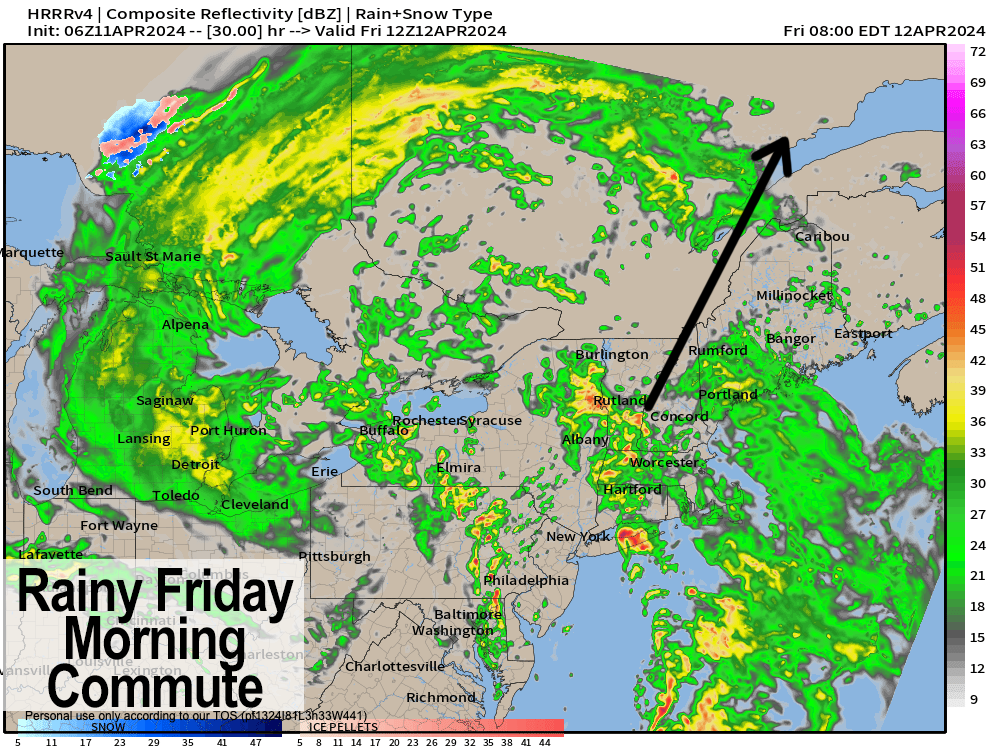
–A northeasterly-sweeping cold front swings heavier and/or steadier rainfall into the greater WMass region around or after sunset, lasting through Friday morning
–Lows hang in the mid 50s tonight!
–Thunder is also possible by early Friday morning, and the Friday morning commute may be slowed should heaviest rains pass thru at that time
–The front sweeps the region by afternoon, with everyone gusting 20-35mph out of the west-southwest Friday night into Saturday
–1-2″ of rainfall is expected
–A few more Saturday morning showers possible with wraparound moisture from parent low that tracks into Ontario
–Otherwise, a dry period works through Saturday afternoon into Sunday afternoon
–Highs Sat. are mid 40s to low 50s and blustery, with highs Sun. mid 50s to low 60s and partly sunny
–By Sunday night a quick wave of showers whips through, and then The Warmening commences Monday and Tuesday with mostly sunny skies
–Highs Mon. low to upper 60s, with highs upper 60s to low/mid 70s on Tuesday before a few more light showers are possible mid-week
~~~~~~~~~~~~~~~~~~~~~~
YOUR MORNING DISCUSSION
~~~~~~~~~~~~~~~~~~~~~~
Good morning everybody, more wet weather is on the way today and tomorrow (and even minor amounts on Sat. AM and Sun. PM) with the bulk of the rainfall coming tonight into Friday morning.
We’re kicking off the day with temps in the 40s to low 50s and patchy fog / drizzle around, with notably dense fog in CMass and SVT.
Patchy fog may linger for a bit day, and we’ve also got a cluster of showers tracking northeast toward southwest New England as of this writing.
These should wet the ground with mainly light to perhaps moderate showers in western CT, WMass, and SVT and a few points east of I-91 mid morning to early afternoon, with drier conditions east of there, and a generally dry afternoon ahead with a few spot showers and highs either side of 60º.
We’ve got a strong temperature inversion in place (milder aloft, cooler surface) and that always hinders the mixing of wind down to the surface, especially in valley locations.
As that southerly flow strengthens this afternoon, tonight and Friday morning, I expect the high terrain areas in the hilltowns, Berkshires/Taconics, northern Litchfields, Worcester Highlands, Mondnock and southern Greens should see gusts of 25-40mph by this afternoon and overnight, with lesser (if any) gusty winds in the Pioneer Valley floor.
However, as this flow strengthens, deeper moisture will flow into the region from south to north tonight, and steadier and heavier rainfall will move through tonight and into Friday morning, with thunder possible, and a few downpours with lows hanging in the 50s (patchy fog possible, too).
This has impacts for the Friday morning commute in terms of ponding on road ways, lowered visibility, and overall slower travel if the heaviest rain times with your personal commute.
Rain runs thru the region Friday morning, and then our cold front runs through the region Friday afternoon as winds veer from southeast and south, to southwest and west with gusts 20-35mph that should last intermittently from later Friday afternoon through the night and into Saturday.
Friday’s highs crest into the low 60s with lows in the mid 40s, and Saturday highs not rising much off of the lows, reaching the mid 40s to low 50s.
A few morning showers from wraparound moisture work through early Saturday morning then we dry out, but stay blustery into the afternoon, with likely a dry Saturday night ahead.
Sunday looks brighter with partly sunny skies, and milder with highs mid 50s to low 60s, and drier… for the daylight hours.
By nighttime a quick wave brings some more showers, which then opens up our first episode of The Warmening, as sunshine develops with high pressure Monday into Tuesday and highs well into the 60s Monday, and upper 60s to mid 70s on Tuesday!
A chance then exists for mid-week showers, but it doesn’t look like a washout at the moment, so that’s better news?
If you throw tomatoes at me, just know that I’ll make delicious sauce with them, or “gravy” as those from the old country call it.
Have a great day!
>>> BE KIND <<<
“Hello babies. Welcome to Earth. It’s hot in the summer and cold in the winter. It’s round and wet and crowded. On the outside, babies, you’ve got a hundred years here. There’s only one rule that I know of, babies: Goddamn it, you’ve got to be kind.”
–Kurt Vonnegut