
TABLE OF CONTENTS
* Daily Celestials (Sun/Moon Data)
* Weekly Weather Nutshell
* Morning Discussion
* TIP: Scroll below for sections, or read all
~~~~~~~~~~~~~~~~~~~~~~
YOUR DAILY CELESTIALS
~~~~~~~~~~~~~~~~~~~~~~
STAR:
–OUR STAR ROSE AT: 6:17am this morning
–OUR STAR SETS AT: 7:26pm this evening
–TOTAL DAYLIGHT TIME: 13 hours and 9 minutes
MOON:
–OUR MOON SETS AT: 10:16pm tonight
–MOON SET DIRECTION: West-Northwest
–OUR MOON RISES AT: 7:42am tomorrow morning
–MOON RISE DIRECTION: East-Northeast
–MOON PHASE: Waxing Crescent 4.1%)
~~~~~~~~~~~~~~~~~~~~~~
A NOTE FROM OUR SPONSOR
~~~~~~~~~~~~~~~~~~~~~~
Dave Hayes The Weather Nut is Sponsored by Individual Community Members, Patrons, and Tandem Bagel Company… No matter the weather, Tandem Bagel is always there for you at several valley locations to make your mornings brighter! With *New Pizza Bagels(!)*, along with bagels baked fresh daily (including Gluten-Free options), house-whipped cream cheese, coffee, and tons of lunch options, Tandem is the perfect quick stop for lunch, breakfast, or a coffee and bagel to go. Find them in Easthampton, Northampton, Hadley, Florence, and West Springfield, or use their super-streamlined online ordering tool by visiting their website.
~~~~~~~~~~~~~~~~~~~~~~
YOUR WEEKLY WEATHER NUTSHELL
~~~~~~~~~~~~~~~~~~~~~~
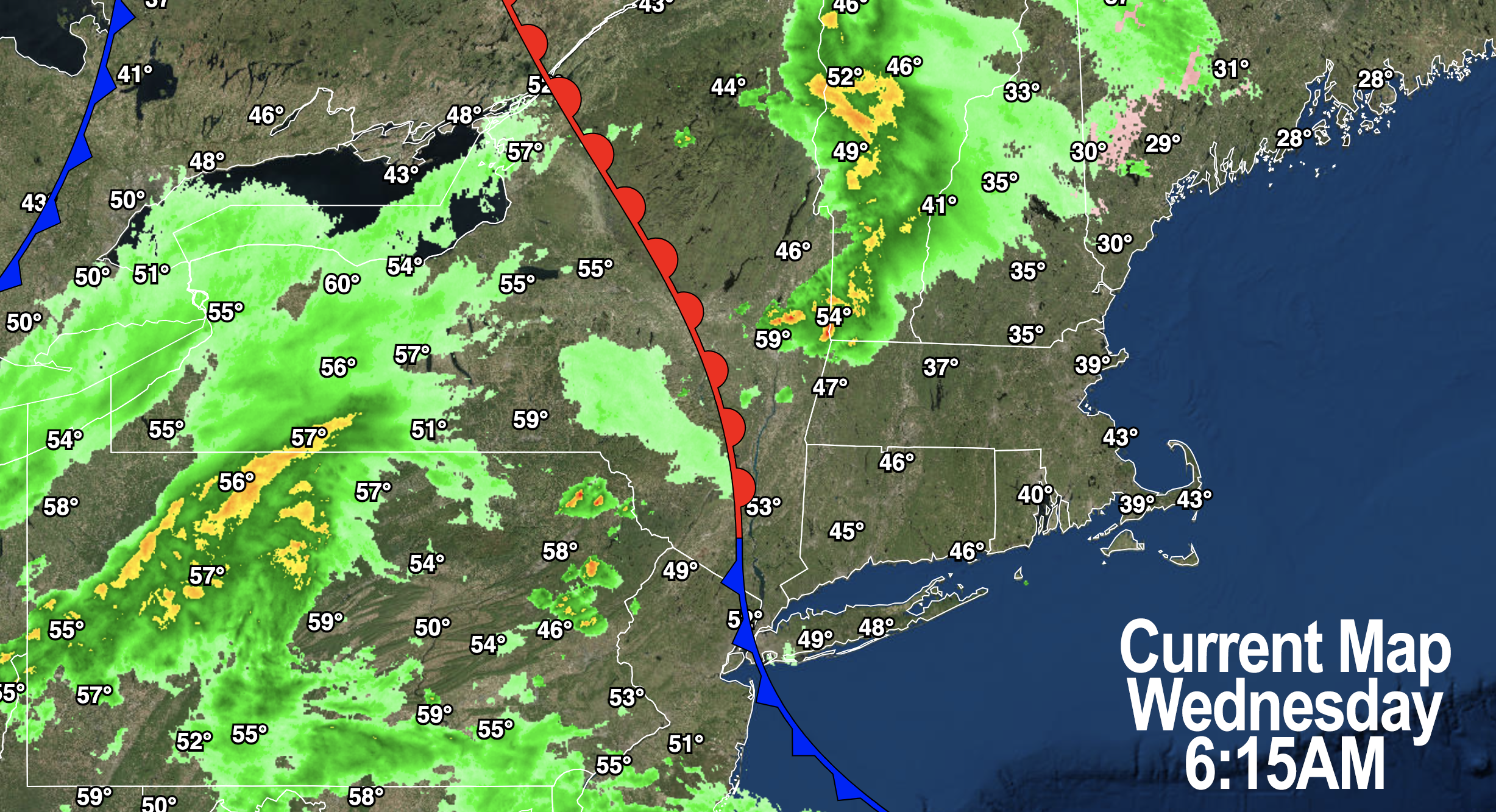
–A warm front is producing much milder temps over southwest VT, far northern Berkshires, and the Taconics this morning
–This is also accompanied by moderate to heavy showers in SVT, northwest MA and heading into SWNH this early morning
–Temps are wildly different, with mid 30s in some western hilltowns, and mid 50s in North Adams, not 30 miles away!
–Highs will reach the upper 50s to low 60s as clouds continue to thicken today
–After this morning’s showers, another round moves in later this afternoon and evening, mostly north of the MA/CT state line
–Overnight we’ll be in a mild and moist air mass with lows in the mid to upper 40s along with patchy fog and drizzle at times
–Fog may become dense in some areas
–For Thursday, we’ll see another warm front push into the region as low pressure lifts northeast through the center of the country and heads for Lake Michigan
–This will bring some scattered showers through Thursday morning into mid-day, with highs in the upper 50s
–By Thursday late afternoon and evening, much more widespread rain showers, and heavier ones at that with a few thunderstorms possible will swing into the region
–This will be ahead of a cold front that runs through our region by Friday afternoon
–Rain will fall moderate to heavy at times Thursday night into Friday, with heaviest rains along the east-facing slopes of the Berkshires, Litchfields and southern Greens
–Anywhere from 0.75″ to 1.5″ or so of rainfall will result by Friday evening
–While there should be a temperature inversion in place, we should still see gusting southeast winds of 20-35mph Thursday night with lows in the 50s and patchy fog at times
–Wind should be present (especially in the high terrain) on Friday, and then our front will sweep the region sometime in the afternoon with highs in the low to mid 60s
–Wind gusts kick around from the west and southwest behind the front for Friday night with lows in the low to mid 40s
–Saturday is going to start off nestled within the cyclonic flow of our upper low and departed surface low with westerly winds gusting to 35mph at times
–Highs will be cooler, in the mid 40s to low 50s, mostly cloudy, and with a few instability showers around
–It’ll be cool Saturday night with lows in the mid 30s to low 40s with breezy conditions continuing
–By Sunday, a partly sunny day develops with milder temps and highs either side of 60º
–Get out and enjoy it EARLY as another quick moving system brings some showers by evening and overnight, prior to high pressure moving in early next week
–We’ve got a big springtime feel coming for early next week, it would appear, as sunshine develops with highs in the 60ds
–However, I do not see any weeks-long dry periods, with more shower chances by later next week
~~~~~~~~~~~~~~~~~~~~~~
YOUR MORNING DISCUSSION
~~~~~~~~~~~~~~~~~~~~~~
Good morning everybody, I hope you had a great day yesterday, it certainly was lovely outside. I spent the day working on my taxes, how’s that for day-off activities, woo hoo, party time! LOL.
Anyway, I wish I had better news in the weather department in terms of prolonged dry and sunny stretches, which at this point would be beneficial.
However, no such luck exists for us as the next three days will feature wet weather at times (today = this morning north of Rt. 2 and this evening generally north of the MA/CT state line… tomorrow = morning to mid-day showers, then heavier/steadier rains Thursday night into Friday early afternoon).
Winds will kick up ahead of and behind our cold frontal passage, though many of us are more likely to see wind Friday night through Saturday, as there will be an inversion in place Thursday night into Friday morning, which tends to prevent valley wind from developing too much, and instead relegating those pre-frontal gusts to the high terrain.
Saturday features a few gusty instability showers and cooler climes, with a warmer and sunnier day on Sunday before more showers move in during the evening and overnight.
We have to wait until early next week to get some deeper sunshine with corresponding springy temps well into the 60s to develop.
Onward we trudge through additional incoming rounds of liquid hydrometeors and suspended tiny water droplets.
At least it won’t be sleeting or graupeling, I suppose.
Have a great day!
>>> BE KIND <<<
“Hello babies. Welcome to Earth. It’s hot in the summer and cold in the winter. It’s round and wet and crowded. On the outside, babies, you’ve got a hundred years here. There’s only one rule that I know of, babies: Goddamn it, you’ve got to be kind.”
–Kurt Vonnegut