
__________________________________
2023 WEATHER WALL CALENDAR AVAILABLE TO ORDER
–Serene and gorgeous local WMass photos
–Deep-dives into the Top 12 most remarkable regional storms including their impacts, my personal stories, and the under-the-hood meteorology that allowed them to form
–12 weather-themed haiku
–Featured article on how the Sun drives Earth’s weather, and much more!
Good morning! Rise and burp, I mean shine! We’ve got highly variable temps out there this morning (some upper 20s, some low 40s) with patchy frost, no doubt. A pair of sunny days are on the way with increasing temps, to be followed by clouds and showers Sunday into Monday and then partly sunny to mostly cloudy skies with mild temps next week with more showers possible Thursday, but before we jump into the details, let’s check a note from our local and delicious sponsor, #TandemBagelCo, with their newest location in West Springfield, MA.
——————–
A NOTE FROM OUR SPONSOR:
DHTWN Is Sponsored by Members, Patrons & Tandem Bagel Company: No matter the weather, Tandem Bagel is always there for you at several valley locations to make your mornings brighter! With bagels baked fresh daily (including Gluten-Free options), house-whipped cream cheese, coffee, and tons of lunch options, Tandem is the perfect quick stop for lunch, breakfast, or a coffee and bagel to go. Find them in Easthampton, Northampton, Hadley, Florence, and West Springfield, or use their super-streamlined online ordering tool by visiting their website.
——————————————-
***DHTWN DAILY WEATHER REPORT***
——————————————-
NWS ALERTS
–Frost Advisory for southern Litchfield County CT expires this morning.
DHTWN REMINDER
–The odds of being a human is 1 in 400,000 billion… make it count, even in a small way (see Kurt Vonnegut quote at end of post)
DAILY CELESTIAL (STAR):
–OUR STAR ROSE AT: 7:09am this morning
–OUR STAR WILL SET AT: 5:59pm this evening
–TOTAL DAYLIGHT TIME: 10 hours and 50 minutes
DAILY CELESTIAL (MOON):
–OUR MOON WILL SET AT: 4:36pm this afternoon
–OUR MOON WILL RISE AT: 3:52am tomorrow morning
–MOON SET DIRECTION: West-Northwest
–MOON RISE DIRECTION: East
–MOON PHASE: Waning Crescent (17.1%)
———————-
DAILY TERRESTRIAL (ZoneCast)
ZONE 1 (Northern Region)
Southern VT, Southwest NH, N. Taconics NY
–High Temps: Mid 50s to Low 60s
–Low Temps: Upper 20s to Mid 30s
–Wind: Light Southwest Wind
–Skies: Mostly sunny
–Precipitation: None
ZONE 2 (Central Region)
WMass, N. CMass, N. Litchfield County, C./S. Taconics NY
–High Temps: Upper 50s to Low 60s
–Low Temps: Low to Mid 30s, some Upper 30s mixed in
–Wind: Light Southwest Wind
–Skies: Mostly sunny
–Precipitation: None
ZONE 3 (Southern Region)
S. CMass, S. Litchfield County, NC.CT, & NE.CT
–High Temps: Upper 50s to Low 60s
–Low Temps: Upper 30s to Low 40s
–Wind: Light Southwest Wind
–Skies: Mostly sunny
–Precipitation: None
———————-
WEATHER REPORT
Good morning fellow human beings, we continue to ply the cosmic substrate on the S.S. Earth with remarkable speed and consistency, no big bumps along our orbit around the galactic center, steady as she goes, the concession cart will be coming by soon in case you want a bag of peanuts or some water, so just hang tight.
In other news, and wouldn’t you just know it, we have MORE weather today! It just keeps coming, doesn’t it? Like waves lapping the ocean beach, another day has arrived, so let’s jump into the deets as the kids like to say (do they like to say that still? Probably not, that’s so 2004, Dave).
NON-SUMMERY SUMMARY
–A huge lobe of high pressure stretches northeast to southwest across the entire east coast this morning and is sliding east
–This will provide a pair of gorgeously sunny days today and tomorrow, with light wind
–Highs today reach the mid 50s to low 60s, with lows tonight in the upper 20s to upper 30s with isolated frost possible
–Highs Saturday will be milder, reaching the low to mid 60s with clouds building at night and lows bottoming out into the upper 40s to low 50s
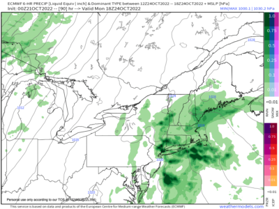
–We’ll be mostly cloudy by Sunday morning as low pressure along the coast bobs north-northwest with a fairly odd track, and that will develop showers by later afternoon into the evening in southeastern areas first (northeast CT, southern CMass) and northwest areas at night (rest of WMass, SVT, western CT etc)
–Highs will top out in the low to mid 60s with a rainy night expected Sunday night with lows in the upper 40s to low 50s
–Heaviest and steadiest rain will fall east of the I-91 corridor the way it looks now
–Monday looks showery in the morning, and then showers should become less numerous as that storm tracks away
–Highs will reach the low 60s with lows in the low 50s with a few showers possible at night
–Tuesday and Wednesday are in-between days with a southeasterly onshore flow that may produce an isolated shower or two with mostly cloudy skies and highs in the low to mid 60s
–By Thursday, another cold front may combine with another coastal system to produce more rainfall over the region
–Temps look mild through the end of next week, no big storms or cool down in sight at the moment
Have a great day, and if you like my work you can support it by buying one or three (for gifts!) of my 2023 calendars… it’s a great local-color-filled daily companion and this year is replete with tons of cool local storm history!
2023 WEATHER WALL CALENDAR AVAILABLE TO ORDER
Did you know that you can also follow me on Twitter?
AND REMEMBER…
“Hello babies. Welcome to Earth. It’s hot in the summer and cold in the winter. It’s round and wet and crowded. On the outside, babies, you’ve got a hundred years here. There’s only one rule that I know of, babies: Goddamn it, you’ve got to be kind.”
–Kurt Vonnegut