
Rainy New Year’s Ahead
——————————-
DAVE’S WEEKLY WEATHER NUTSHELL
–A cold start to our Moon Day, I mean Monday
–Fair weather dominates through Friday, with increasingly mild temperatures
–A few flurries are possible overnight tonight with clouds
–Otherwise, a mix of sunny days with some clouds at times
–We become overcast New Year’s Eve (Saturday)
–Showers arrive New Year’s Eve and last into New Year’s Day with very mild temps
–We’re overall mild first week of January, which may extend into 2nd week when a return to winter cold is signaled
Now then, before we jump into the weather discussion/details below, let’s check a note from our local and delicious sponsor, #TandemBagelCo, with their newest location in West Springfield, MA.
——————–
A NOTE FROM OUR SPONSOR:
DHTWN Is Sponsored by Members, Patrons & Tandem Bagel Company: No matter the weather, Tandem Bagel is always there for you at several valley locations to make your mornings brighter! With bagels baked fresh daily (including Gluten-Free options), house-whipped cream cheese, coffee, and tons of lunch options, Tandem is the perfect quick stop for lunch, breakfast, or a coffee and bagel to go. Find them in Easthampton, Northampton, Hadley, Florence, and West Springfield, or use their super-streamlined online ordering tool by visiting their website.
——————————————-
***DHTWN DAILY WEATHER REPORT***
——————————————-
NWS ALERTS
–None
DHTWN REMINDER
–The odds of being a human is 1 in 400,000 billion… make it count, even in a small way (see Kurt Vonnegut quote at end of post)
DAILY CELESTIAL (STAR):
–OUR STAR ROSE AT: 7:17am this morning
–OUR STAR WILL SET AT: 4:24pm this evening
–TOTAL DAYLIGHT TIME: 9 hours and 7 minutes
NIGHTLY CELESTIAL (MOON):
–OUR MOON WILL SET AT: 8:22pm this evening
–OUR MOON WILL RISE AT: 10:53am tomorrow morning
–MOON SET DIRECTION: West-Southwest
–MOON RISE DIRECTION: East-Southeast
–MOON PHASE: Waxing Crescent (13.6%)
———————-
DAILY TERRESTRIAL (ZoneCast)
ZONE 1 (Northern Region)
Southern VT, Southwest NH, N. Taconics NY
–High Temps: Mid to Upper 20s
–Low Temps: Mid Teens
–Wind: Light Westerly
–Skies: Mostly Sunny, partly sunny later
–Precipitation: A few flurries possible overnight, otherwise dry
ZONE 2 (Central Region)
WMass, N. CMass, N. Litchfield County, C./S. Taconics NY
–High Temps: Mid 20s to Low 30s
–Low Temps: Mid to Upper Teens
–Wind: Light Westerly
–Skies: Mostly Sunny, partly sunny later
–Precipitation: A few flurries possible overnight, otherwise dry
ZONE 3 (Southern Region)
S. CMass, S. Litchfield County, NC.CT, & NE.CT
–High Temps: Mid 20s to Low 30s
–Low Temps: Upper Teens
–Wind: Light Westerly
–Skies: Mostly Sunny, partly sunny later
–Precipitation: None expected
———————-
WHERE’S DAVE?
–I’ve been reporting our weather daily here and at https://www.westernmassweather.com for almost 10 years
–Sign up for my free weekly newsletter here: https://westernmassweather.com/homepage/dhtwn-nutletter-signup/
–Please visit my this FB page via the app or web like selecting a channel you want to tune into if I’m not auto-kissing your screens
–I’m always here daily, so keep stopping by!
———————-
MORNING DISCUSSION
Good morning everybody, I hope the conclusion of the late-December holiday season has been a pleasant one for you all. I had a lovely relaxing day with my sweetie, her kids and her old friend, and feel immensely grateful for my life, and for all of you who read my work, appreciate it, encourage it, and financially support it. Thank you!
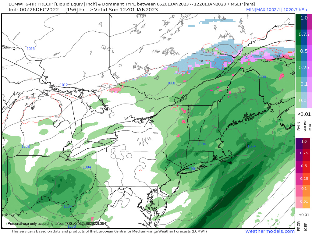
As for our weather pattern, we’re shifting into a less-busy, milder pattern as a eastern upper level ridge sets up to our south and drives milder air into our region by this late-week period into next week, which will deflect most storm systems north of us except one: a New Year’s rainy system that will be accompanied by mild temps and zero chance of wintry weather.
For today, we’ll move through the last unseasonably cold day in our three-day cold snap with highs in the 20s, as a few of us try to reach the freezing mark in the low 30s under mostly sunny skies.
We may see more partly sunny skies late with clouds increasing overnight due to a wave that will pass north of us, but could produce a few snow flurries or light snow showers with lows in the teens.
For Tuesday, light winds and mostly sunny skies develop as high pressure moves in from the southwest. It’ll still be cold with highs in the upper 20s to low 30s, and with lows in the teens.
Then The Mildening commences on Wednesday as high pressure starts to track south of us, which puts us in a more southerly flow with highs in the mid to upper 30s under partly sunny skies with lows in the low to mid 20s.
Thursday and Friday are much milder with highs in the low to mid 40s Thursday and mid to upper 40s on Friday under partly sunny skies with lows in the 20s and 30s respectively.
Then we cloud up for real on Saturday, which is New Year’s Eve, and should see some rain showers move in by afternoon or night (timing TBD). Highs will reach the upper 40s to low 50s on Saturday, and then the low to mid 50s on Sunday as showers continue under mostly cloudy skies.
Have a great day, and if you missed the order deadline I still have my 2023 weather calendars with gorgeous and local WMass photos at the link below: I won’t be doing one next year, so get ’em while you can!
Follow me on Twitter while it’s still a thing.
AND REMEMBER…
“Hello babies. Welcome to Earth. It’s hot in the summer and cold in the winter. It’s round and wet and crowded. On the outside, babies, you’ve got a hundred years here. There’s only one rule that I know of, babies: Goddamn it, you’ve got to be kind.”
–Kurt Vonnegut