>>> YOUR DAILY CELESTIALS <<<
STAR:
–OUR STAR ROSE AT: 6:21am this morning
–OUR STAR WILL SET AT: 7:14pm this evening
–TOTAL DAYLIGHT TIME: 12 hours and 53 minutes
MOON:
–OUR MOON WILL RISE AT 11:45pm tonight
–MOON RISE DIRECTION: Northeast
–OUR MOON WILL SET AT: 4:09pm tomorrow afternoon
–MOON SET DIRECTION: Northwest
–MOON PHASE: Waning Crescent (45.2%)
~~~~~~~~~~~~~~~~~~~~~~
>>> DAVE’S WEEKLY WEATHER NUTSHELL <<<
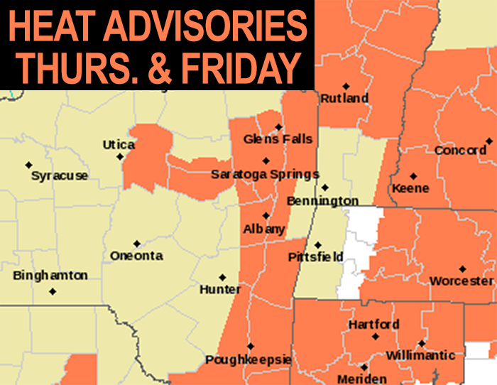
–Heat Advisories continue today for heat indices (combo of air temps and dewpoint temps) reaching 95-100º
–Mostly sunny skies are expected
–A hot and humid day means stay hydrated and out of the peak heat of the day which is late morning into mid/late afternoon if you’re sensitive to heat/humidity
–Some isolated showers and thunderstorms are possible late in the day, mainly after sunset, and mostly in the western hilltowns up into SVT and out into the Berkshires
–Patchy fog overnight, like this morning
–Hot and humid tomorrow, but not as bad with more clouds as our heat wave breaks with Friday’s sunset
–A better chance exists for scattered showers and thunderstorms, with some street flooding possible in heavier downpours during the afternoon and evening
–Highs on Saturday in the 80s, with highs on Sunday in the 75-80º range will feature afternoon shower/storm chances each day and continued humidity
–This likely stretches into Monday as we are in a slow-moving pattern thanks to Idalia’s remnants south of Nova Scotia and now this exiting upper level ridge that has brought the heat and humidity
–Cooler/drier conditions should start to mix in by mid week, but then we will be watching Hurricane Lee to see if it impacts New England, but before we talk details let’s check a note from our local and delicious sponsor, #TandemBagelCo, with their newest location in the Stop & Shop Plaza on King Street in Northampton, MA.
~~~~~~~~~~~~~~~~~~~~~~
>>> A NOTE FROM OUR SPONSOR <<<
Dave Hayes The Weather Nut is Sponsored by Individual Community Members, Patrons & Tandem Bagel Company… No matter the weather, Tandem Bagel is always there for you at several valley locations to make your mornings brighter! With bagels baked fresh daily (including Gluten-Free options), house-whipped cream cheese, coffee, and tons of lunch options, Tandem is the perfect quick stop for lunch, breakfast, or a coffee and bagel to go. Find them in Easthampton, Northampton, Hadley, Florence, and West Springfield, or use their super-streamlined online ordering tool by visiting their website.
>>> MORNING DISCUSSION <<<
Good morning folks, we’re starting off with patchy fog in spots today, notably in Pittsfield and Orange, but that will burn off quickly as temps come up faster than dewpoints can rise.
We’re starting off warm, and as an upper ridge crests through the region today, temps will soar under mostly sunny skies into the upper 80s to mid 90s, which will push heat indices into the 95-100º range.
By late in the day, the ridge will slowly be pushing east, and this will allow some easternmost areas of a pre-frontal trough environment to edge over the NY state line with CT, MA and VT, where some isolated showers or a few thunderstorms could fire, and we can’t rule out a strong to severe one.
This would be mostly for the Berkshires, northwest hilltowns of WMass and SVT, and would more likely occur near or after sunset.
Lows tonight will dip into the 60s to low 70s with continued humid conditions, and patchy fog.
For Friday, our final heat wave day arrives, with highs expected to reach the mid 80s to low 90s under partly sunny skies.
This time around, we’ll get more instability and better wind shear to push further east into the greater WMass region, and so I expect scattered showers, downpours and thunderstorms, with some street flooding possible along with strong gusty winds and/or hail.
This activity should be focused in the mid afternoon to early evening, and then dissipate at night with lows again 65-70º and continued humid.
This exiting upper ridge will be very slow to pull away, as will the incoming trough be very slow to move into our region.
I’m afraid that means substantial humidity sticks around (get it? IT *STICKS* AROUND!!!) through the weekend and into early next week at least.
High temps tamp down over the weekend to essentially 80-85º Saturday and 75-80º on Sunday with afternoon showers/storms possible each day, especially on Sunday when a slow-moving cold front should be pressing into the region, helping to spark showers, downpours and storms (some of which may cause additional street flooding).
This activity continues into Monday, but at some point Monday or Monday night a cold front should saunter through the region, helping to cool temps down by the middle of next week along with humidity.
However, that appears to be short-lived as another trough and frontal boundary will be approaching by late week.
This is CRITICAL for interactions with Hurricane Lee and how that storm may be drawn up the coastline to potentially impact us here.
For now, it’s more likely that Nova Scotia or Newfoundland bear impacts, but I will keep you updated, as it is a week from tomorrow through Saturday when Lee could become an issue.
After THAT, we should get a real taste of early Autumn. Often times, higher-latitude tropical systems help hasten seasonal changes here in southern New England by pulling in drier, cooler Canadian air that’s waiting in the wings, ready to be tapped.
I will keep you updated, have a great day!
>>> BE KIND <<<
“Hello babies. Welcome to Earth. It’s hot in the summer and cold in the winter. It’s round and wet and crowded. On the outside, babies, you’ve got a hundred years here. There’s only one rule that I know of, babies: Goddamn it, you’ve got to be kind.”
–Kurt Vonnegut
