
TABLE OF CONTENTS
* Daily Celestials (Sun/Moon Data)
* Sponsor Note
* Morning Discussion
* TIP: Scroll below for sections, or read all
~~~~~~~~~~~~~~~
YOUR DAILY CELESTIALS
~~~~~~~~~~~~~~~~~~~~~~
STAR:
–OUR STAR ROSE AT: 6:30am this morning
–OUR STAR SETS AT: 7:17pm this evening
–TOTAL DAYLIGHT TIME: 12 hours and 47 minutes
MOON:
–OUR MOON RISES AT: 9:40am this morning
–MOON RISE DIRECTION: Northeast
–OUR MOON SETS AT: 2:15am tomorrow morning
–MOON SET DIRECTION: Northwest
–MOON PHASE: Waxing Crescent (22.1%)
~~~~~~~~~~~~~~~~~~~~~~
A NOTE FROM OUR SPONSOR
~~~~~~~~~~~~~~~~~~~~~~
Dave Hayes The Weather Nut is Sponsored by Individual Community Members, Patrons, and Tandem Bagel Company… No matter the weather, Tandem Bagel is always there for you at several valley locations to make your mornings brighter! With *New Pizza Bagels(!)*, along with bagels baked fresh daily (including Gluten-Free options), house-whipped cream cheese, coffee, and tons of lunch options, Tandem is the perfect quick stop for lunch, breakfast, or a coffee and bagel to go.
You can either 1) visit them in Easthampton, Northampton, Hadley, Florence, and/or West Springfield, 2) hire them to cater your next event, or 3) use their super-streamlined online ordering tool by visiting their website and clicking the “Catering” or “Order Online” links.
~~~~~~~~~~~~~~~~~~~~~~
YOUR MORNING DISCUSSION
~~~~~~~~~~~~~~~~~~~~~~
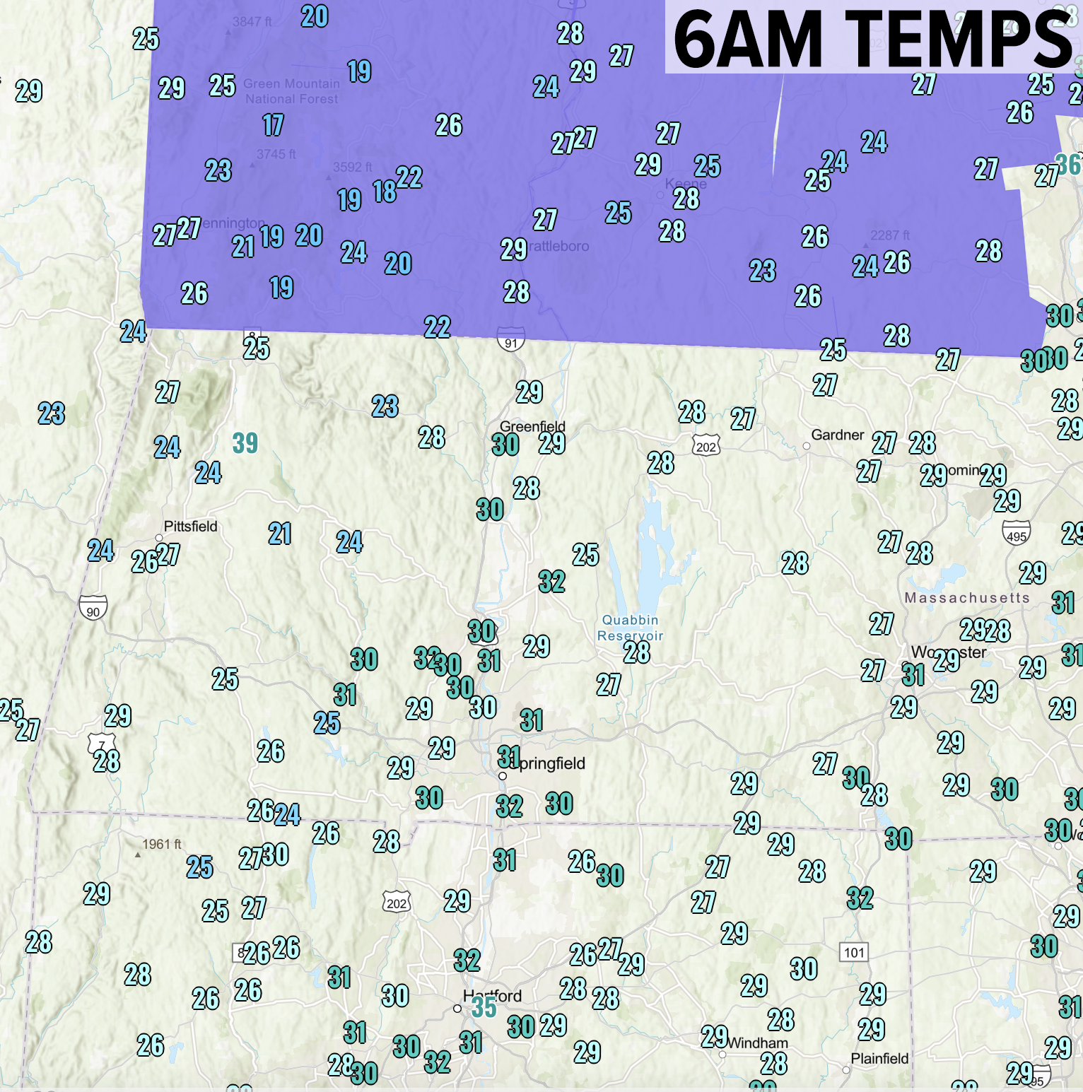
Good morning everybody, we have a cold start to the day with temps mostly in the 20s, with some low 30s mixed in and upper teens noted in SVT! Brrrr!
A warm front will be approaching our region and working through overnight with mixed precipitation earlier on with some minor travel impacts in northern MA, SVT and SWNH, changing to rain by Thursday morning.
Before that happens, we’ll enjoy a cool, but partly sunny day with light and variable wind and highs in the 40s.
By sometime after 7pm or 8pm tonight, a mix of snow, ice and rain showers will push into our region from the southwest.
As mentioned in the headline, Winter Weather Advisories are up for southern VT and southwest NH due to this incoming mix, with a coating to an inch of snow possible, along with some sleet and up to a tenth of an inch or so of ice accretion in those areas, with some coatings of snow/sleet and freezing rain glazes in far northern MA.
As precipitation moves in and becomes steadier toward midnight, that could create a bit of dynamic cooling to cool the column down and provide a burst of sleet after any initial snow, but warm air will eventually win out by dawn except for the highest terrain in northern areas of SVT and SWNH, turning anyone with wintry precip to rain.
South of Route 2 should be mostly rain, with some mix possible overnight between the CT/MA state line north to Rt. 2.
Lows will drop to the upper 20s to upper 30s and rise into Thursday morning with periods of rainfall during the morning tapering off in the afternoon with highs in the upper 50s to mid 60s behind the front as our yo-yo weather continues. Lows will drop into the 40s Thursday night.
For Friday, we’ll enjoy a partly sunny day with highs in the 50s to low 60s, but a cold front will drop through overnight, setting us up for a cool and increasingly showery Saturday.
After lows Friday night into the 30s, we will probably hang in the 40s on Saturday as showers arrive by about mid-day and continue into the evening as another frontal boundary gets hung up over southern New England #booooohisssssss
It’ll be good for May flowers and leaf out and such, but kind of a bummer for folks looking for a nice weekend, as Sunday doesn’t do too much better.
Said frontal boundary performs a Diurnal Undulational Maneuver (DUM) and pushes north of us for Sunday, pushing high temps into the upper 50s to mid 60s for Sunday with continued cloudiness and periods of showers, probably more towards afternoon with a lull in the morning (hopefully, I will update you on the weekend as we get closer).
Sunday night into Monday features a cold front moving into the region, with more showers, possibly ending as or mixing with snow by early Monday morning in the high terrain.
Early next week should feature fair weather as high pressures moves in with highs mid 40s to mid 50s Monday, but cooling into the mid 30s to mid 40s for Tuesday behind a cold front, after which we’ll have to watch for possible snow showers by mid week.
Whatever comes our way, we’ll deal with it. We’re New Englanders, for cripes sake, and we weather our weather even when it weathers the crap out of us.
Hang in there, do your FaceYoga, take a walk if you can, or otherwise get outside and let the Sun hit you, and remember we’re cruising at a steady 515,000mph through Space. As Bill Hicks said, it’s just a ride, and remember to be nice to somebody today, even if nobody is nice to you.
Have a great day!
“Follow your bliss and the universe will open doors for you where there were only walls.”
― Joseph Campbell