
TABLE OF CONTENTS
* Daily Celestials (Sun/Moon Data)
* Sponsor Note
* Morning Discussion
* TIP: Scroll below for sections, or read all
~~~~~~~~~~~~~~~
YOUR DAILY CELESTIALS
~~~~~~~~~~~~~~~~~~~~~~
STAR:
–OUR STAR ROSE AT: 6:20am this morning
–OUR STAR SETS AT: 7:24pm this evening
–TOTAL DAYLIGHT TIME: 13 hours and 4 minutes
MOON:
–OUR MOON RISES AT: 3:18pm this afternoon
–MOON RISE DIRECTION: East-Northeast
–OUR MOON SETS AT: 5:00am tomorrow morning
–MOON SET DIRECTION: West-Northwest
–MOON PHASE: Waxing Gibbous (82.1%)
~~~~~~~~~~~~~~~~~~~~~~
A NOTE FROM OUR SPONSOR
~~~~~~~~~~~~~~~~~~~~~~
Dave Hayes The Weather Nut is Sponsored by Individual Community Members, Patrons, and Tandem Bagel Company… No matter the weather, Tandem Bagel is always there for you at several valley locations to make your mornings brighter! With *New Pizza Bagels(!)*, along with bagels baked fresh daily (including Gluten-Free options), house-whipped cream cheese, coffee, and tons of lunch options, Tandem is the perfect quick stop for lunch, breakfast, or a coffee and bagel to go.
You can either 1) visit them in Easthampton, Northampton, Hadley, Florence, and/or West Springfield, 2) hire them to cater your next event, or 3) use their super-streamlined online ordering tool by visiting their website and clicking the “Catering” or “Order Online” links.
~~~~~~~~~~~~~~~~~~~~~~
YOUR MORNING DISCUSSION
~~~~~~~~~~~~~~~~~~~~~~
Good morning folks, a word to the wise: don’t eat ice cream before bed, no matter whether it’s the best ice cream you’ve ever tasted in your life, or you’ll grow up to have whacked dreams and disturbed sleep like this writer did overnight. #NotWorthIt #Zzzzzzzzzzzz
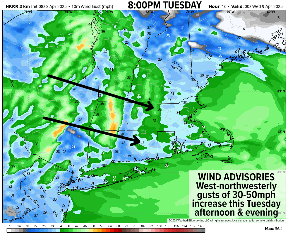
As for our weather, we have a cold front sweeping the region this morning with snow, sleet and rain depending on whether you’re in the hills or down in the valley, or anywhere in between.
Some coatings are possible where we’re snowing in the high terrain this morning, especially in northwest MA and/or southern VT.
This activity will move through and out of WMass and CMass between 7-10am, with fog or drizzle dissipating as we dry out behind the exiting cold front. Highs will rise into the 30s to low 40s, but then drop in the afternoon as our westerly winds begin to develop.
Wind Advisories are up for WMass and CMass, and may need to be expanded into northern CT and other areas, with gusts of 30-50mph expected.
As these winds ramp up deeper into the afternoon and earlier evening tonight, some isolated power outages will develop.
In addition, scattered upslope and/or lake effect snow showers will produce scattered coatings to an inch, with maybe up to 2” or so in the southern Green Mountains of VT by tonight.
But wait, there’s more! Adding more additions to our in-addition statements, these wind gusts are going to combine with any snow showers to lower visibility, as well as to drop temps into the mid 20s to mid 30s by dusk, producing wind chills in the teens and 20s late today!
Winter’s scorpion tail is snapping back with a whammo!
Now, clearly, I’m being a bit dramatic here.
It’s still early Spring, and it’s historically a transition time from Winter into Spring.
Also, we’ve been getting used to the winter pattern extending into early spring in recent years, but all this to say, the wind and cold and some snow showers will certainly be note-and-newsworthy, especially given that lows tonight will dip into the upper teens to mid 20s with winds gusting to 40mph or so overnight, which will combine to produce wind chills into the single digits!
By Wednesday, the bulk of the wind and any snow showers should be gone as the core of the upper trough that delivered this wintry hit continues to sweep east, leaving us with sunshine and still-cold highs in the mid 30s to mid 40s with westerly gusts to 30mph, slackening by later afternoon.
For Wednesday night, radiational cooling develops in the dry, still, and clear air mass, driving lows down into the low to mid 20s.
By Thursday, southerly flow will develop in the trough’s wake, and high temps will rise well into the 40s to low 50s under partly sunny skies, with clouds increasing later in the day and evening.
A system working out of the Ohio Valley will spread precip into the region overnight with lows dropping into the low to mid 30s, and we could see some more high-terrain snow or sleet, with valley rainfall or mix into Friday morning. I can’t rule out some new wet snow coatings in spots.
For Friday, at this stage, I don’t see temps rising much above 50º, and the same goes for Saturday.
In addition, while it’s wet Friday morning, and while we’ll see a lull in the action (my belief as of now) toward mid-day or afternoon, yet another system with more moisture will punch southwest to northeast into New England by Friday night into Saturday with more rainfall with some high terrain mixed precip possible.
Honestly, at the moment, I am unsure of how the weekend plays out past the first half of an expectedly wet Saturday, as there’s a chance of another system by Sunday afternoon, but that’s too far out in this pattern to have any real certainty.
What we know is that we’ve got a wintry taste moving into the region over the next 48 hours, followed by at least two more wet-weather systems, so even though this is about as unofficial statement as can be made, THE DROUGHT IS OVER.
Hang in there, take a walk or enjoy a spell outside between rain drops and snowflakes (bundled up of course if late in the day), and I hope things go well for you today, some how and in some way!
“Follow your bliss and the universe will open doors for you where there were only walls.”
― Joseph Campbell