
TABLE OF CONTENTS
* Daily Celestials (Sun/Moon Data)
* Sponsor Note
* Morning Discussion
* TIP: Scroll below for sections, or read all
~~~~~~~~~~~~~~~
YOUR DAILY CELESTIALS
~~~~~~~~~~~~~~~~~~~~~~
STAR:
–OUR STAR ROSE AT: 6:09am this morning
–OUR STAR SETS AT: 7:31pm this evening
–TOTAL DAYLIGHT TIME: 13 hours and 22 minutes
MOON:
–OUR MOON SET AT: 7:01am this morning
–MOON SET DIRECTION: West-Southwest
–OUR MOON RISES AT: 10:38pm this evening
–MOON RISE DIRECTION: Southeast
–MOON PHASE: Waning Gibbous (94.7%)
~~~~~~~~~~~~~~~~~~~~~~
A NOTE FROM OUR SPONSOR
~~~~~~~~~~~~~~~~~~~~~~
Dave Hayes The Weather Nut is Sponsored by Individual Community Members, Patrons, and Tandem Bagel Company… No matter the weather, Tandem Bagel is always there for you at several valley locations to make your mornings brighter! With *New Pizza Bagels(!)*, along with bagels baked fresh daily (including Gluten-Free options), house-whipped cream cheese, coffee, and tons of lunch options, Tandem is the perfect quick stop for lunch, breakfast, or a coffee and bagel to go.
You can either 1) visit them in Easthampton, Northampton, Hadley, Florence, and/or West Springfield, 2) hire them to cater your next event, or 3) use their super-streamlined online ordering tool by visiting their website and clicking the “Catering” or “Order Online” links.
~~~~~~~~~~~~~~~~~~~~~~
YOUR MORNING DISCUSSION
~~~~~~~~~~~~~~~~~~~~~~
Good morning folks, did anyone hear thunder last night? Some elevated storms kicked up over the northeast U.S., though most of us just saw some scattered showers with some on the heavier side.
As for the rest of our Tuesday, we’ll see some sunny periods but it should be mostly cloudy as a cold front approaches the region, set to pass through from west to east tonight.
Highs will reach the upper 50s to mid 60s which will be easier on the aging bones compared to recent weeks and weekends.
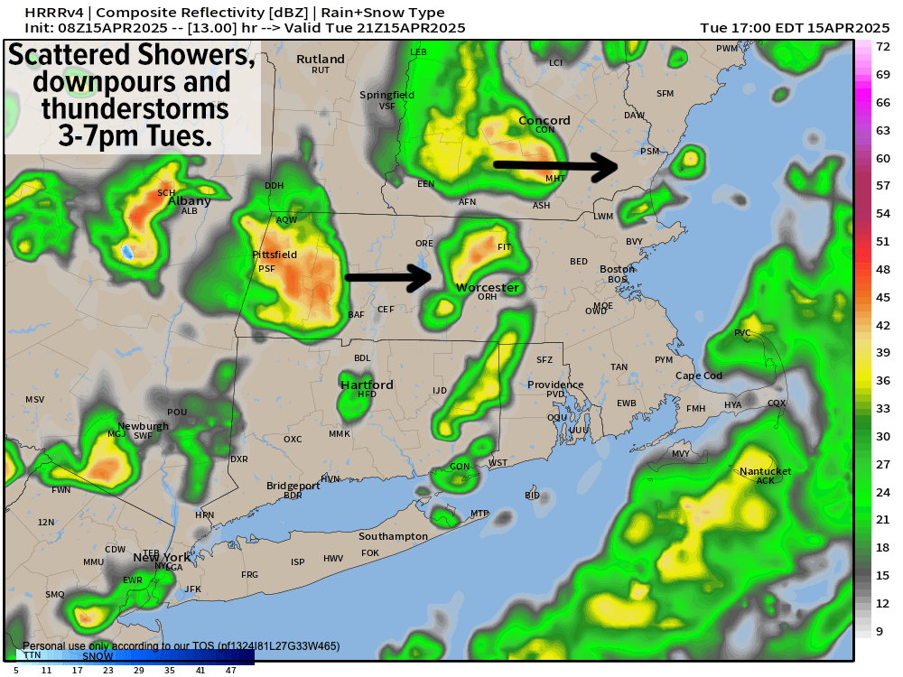
We’ll probably see some scattered showers running northeast by late morning into early afternoon, mostly over northern CT, CMass and southeastern parts of WMass like eastern Hampshire/Hampden Counties.
Beyond that, by mid to late afternoon the cold front will be pushing into the Hudson Valley of eastern NY and out ahead of it, we’ll see scattered showers, downpours and thunderstorms developing.
These should move through our region roughly between 3-7pm today, and some could produce heavy rain, or even small hail and/or graupel (a/k/a “soft hail”, and are essentially snowflakes encased in a thin layer of rime ice). Winds may be gusty in a couple of these cells, too.
After the front clears the region early tonight, we’ll see west-northwest winds pick up as cooler air advects into the region, gusting 25-40mph late tonight into and through Wednesday. Lows dip into the low to mid 30s tonight.
In addition, scattered lake effect and/or upslope snow showers will affect mostly the Berkshires, Taconics and southern VT, but may survive the trip east into the western hilltowns or northern valley, and I can’t rule out a coating to an inch or two of snow in the northern Berkshires, western Franklin County and southern VT by Wednesday night.
Wednesday, again, looks blustery with gusts 25-40mph, slackening late, with highs only reaching the 40s under mostly cloudy skies with wind chills in the 30s at times.
Wednesday represents our last taste of Winter as far as I can read the atmospheric tea leaves. Lows will dip into the low to mid 30s as any lingering snow showers wind down.
We’ll end the week on the upswing as an upper ridge of higher pressures aloft starting building east and producing sunshine both days with highs in the upper 40s to mid 50s Thursday (lows low to mid 30s) and highs in the mid 50s to ow 60s by Friday (with lows in the 40s as we clouds increase at night).
Another frontal boundary pushes into the region by Friday night into Saturday with scattered showers, but it does not look like a washout.
Plus, it’ll be a warm front that moves through, and that should drive highs WELL into the 60s, and possibly low 70s!
#Improvements
Sunday looks to be the weekend pick with sunshine developing behind the front, lasting into Monday. Highs should reach the upper 50s to mid 60s with lows near 40º.
Spring is on the move now, folks! Have a great day!
“Follow your bliss and the universe will open doors for you where there were only walls.”
― Joseph Campbell