
–> 100s of storms over 12 years
–> 1000s of daily reports & updates
–> Keep Dave on the job through all our storms
–> We’re 65% to the 4% reader goal, Drive ends 3/16
–> ^^ SecureClick to support Dave’s work ^^
~~~~~~~~~~~~~~~
TABLE OF CONTENTS
* Daily Celestials (Sun/Moon Data)
* Sponsor Note
* Morning Discussion
* TIP: Scroll below for sections, or read all
~~~~~~~~~~~~~~~
YOUR DAILY CELESTIALS
~~~~~~~~~~~~~~~~~~~~~~
STAR:
–OUR STAR ROSE AT: 6:16am this morning
–OUR STAR SETS AT: 5:46pm this evening
–TOTAL DAYLIGHT TIME: 11 hours and 30 minutes
MOON:
–OUR MOON RISES AT: 9:53am this morning
–MOON RISE DIRECTION: Northeast
–OUR MOON SETS AT: 2:23am tomorrow morning
–MOON SET DIRECTION: Northwest
–MOON PHASE: Waxing Crescent (36.8%)
~~~~~~~~~~~~~~~~~~~~~~
A NOTE FROM OUR SPONSOR
~~~~~~~~~~~~~~~~~~~~~~
Dave Hayes The Weather Nut is Sponsored by Individual Community Members, Patrons, and Tandem Bagel Company… No matter the weather, Tandem Bagel is always there for you at several valley locations to make your mornings brighter! With *New Pizza Bagels(!)*, along with bagels baked fresh daily (including Gluten-Free options), house-whipped cream cheese, coffee, and tons of lunch options, Tandem is the perfect quick stop for lunch, breakfast, or a coffee and bagel to go.
You can either 1) visit them in Easthampton, Northampton, Hadley, Florence, and/or West Springfield, 2) hire them to cater your next event, or 3) use their super-streamlined online ordering tool by visiting their website and clicking the “Catering” or “Order Online” links.
~~~~~~~~~~~~~~~~~~~~~~
YOUR MORNING DISCUSSION
~~~~~~~~~~~~~~~~~~~~~~
Good morning everybody, I want to send a shout out to all of the recent patrons and supporters of my work. Historically when 4% of you show up and chip in at any level (even $5 or $10, or a few bucks a month) you’ve kept my life’s work focused on serving you, your family, and this community, so thank you!
As for our weather, we have a busy period coming up for today and tomorrow, and potentially into Saturday as well, with the main player on the field for such busy-ness is *more* wind.
We are starting off quite mild this morning with temps in the 40s to low 50s for many, with patchy dense fog around. This fog will dissipate with time and will be left with mostly cloudy skies.
Highs today will reach the upper 40s to mid 50s and we’ll see some isolated showers working northeast through the region at times (though it will be mostly dry).
In fact, by early to mid-afternoon as a strong cold front approaches from the west, some additional showers should form and could drop some small hail or even graupel (the other icy precip type), as air becomes more unstable due to much colder air working in aloft before the surface front arrives. This creates rising, moist, and unstable air known as convection (i.e. bubbling air parcels like this produce thunderstorms).
Speaking of which, we may even get a rumble of thunder today, but that would likely be well east of I-91. A few breaks of sun are also possible this afternoon.
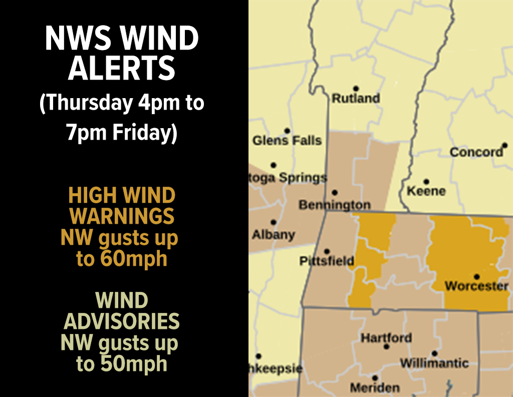
Behind the front later this afternoon into evening, northwest winds will pick up and gust 25-40mph initially, but should ramp up in the evening and overnight, hitting gusts of 40-60mph in the high terrain either side of the Pioneer Valley where High Wind Warnings are up, with Wind Advisories hoisted for the Pioneer valley (the rest of Franklin, Hampshire and Hampden Counties), northern CT, the Berkshires, SVT and eventually SWNH for gusts overnight into Friday of 30-50mph.
In addition, as stronger wind moves in, some upslope snow showers are likely at least in the northern Berkshires up into southwest VT where fresh coatings are possible by Friday morning, as lows drop into the 20s with wind chills dipping into the single digits (and maybe briefly below zero in the highest peaks).
Some outages will probably result in the high terrain areas by Friday mid day.
In addition, we could see some scattered lake effect snow showers tomorrow with highs under partly sunny skies only reaching the mid 30s to low 40s, with wind tamping down by Friday evening with gust up to 30mph and lows dropping into the upper teens to low 20s.
Saturday looks gusty, but not as bad as the next 24-36 hours. It will be cold with highs in the low to mid 30s under partly to mostly sunny skies, with the same sky setup for Sunday as highs struggle to climb into the mid to upper 30s, with lows in the 20s.
We may see a Monday clipper system with light mixed precip by morning, but I will update as we get closer.
Otherwise, Episode #3 of The Mildening starts on Monday with highs cresting into the low to mid 40s.
By Tuesday and Wednesday we may shoot through the 50s into the low 60s by Wednesday, so winter detesters can rejoice, I suppose, though I still want one big snowstorm for cripes sake!!
Anyway, I’ll get over it! Have a great day and Let’s Stick Together in 2025 (secure click to support Dave’s work through 2025 below):
“Follow your bliss and the universe will open doors for you where there were only walls.”
― Joseph Campbell