TABLE OF CONTENTS
* Daily Celestials (Sun/Moon Data)
* Sponsor Note
* Morning Discussion
* TIP: Scroll below for sections, or read all
~~~~~~~~~~~~~~~
YOUR DAILY CELESTIALS
~~~~~~~~~~~~~~~~~~~~~~
STAR:
–OUR STAR ROSE AT: 6:29am this morning
–OUR STAR SETS AT: 7:18pm this evening
–TOTAL DAYLIGHT TIME: 12 hours and 49 minutes
MOON:
–OUR MOON RISES AT: 9:40am this morning
–MOON RISE DIRECTION: Northeast
–OUR MOON SETS AT: 2:15am tomorrow morning
–MOON SET DIRECTION: Northwest
–MOON PHASE: Waxing Crescent (32.5%)
~~~~~~~~~~~~~~~~~~~~~~
A NOTE FROM OUR SPONSOR
~~~~~~~~~~~~~~~~~~~~~~
Dave Hayes The Weather Nut is Sponsored by Individual Community Members, Patrons, and Tandem Bagel Company… No matter the weather, Tandem Bagel is always there for you at several valley locations to make your mornings brighter! With *New Pizza Bagels(!)*, along with bagels baked fresh daily (including Gluten-Free options), house-whipped cream cheese, coffee, and tons of lunch options, Tandem is the perfect quick stop for lunch, breakfast, or a coffee and bagel to go.
You can either 1) visit them in Easthampton, Northampton, Hadley, Florence, and/or West Springfield, 2) hire them to cater your next event, or 3) use their super-streamlined online ordering tool by visiting their website and clicking the “Catering” or “Order Online” links.
~~~~~~~~~~~~~~~~~~~~~~
YOUR MORNING DISCUSSION
~~~~~~~~~~~~~~~~~~~~~~
Good morning everybody, we had about a quarter to two-thirds of rainfall overnight, with icing in northern MA, SVT and SWNH, and plows are still actively treating the roads through the southern Green Mountains of VT this early morning. I note about 125 outages in SVT/SWNH combined, so there may be isolated pockets of damage from more heavily accreted ice in the mountains.
After our sleet burst near dusk last night, most of us turned to rain, and while that has ended for the time being we do have another rain round moving into our region toward mid-morning, with thunder possible, as well as some heavier rain bursts.
Southern VT and a few sporadic parts of northern MA and SWNH are the freezing mark as of this writing, so a bit more icing is possible, but the trend is for temps to increase in southwest flow as the warm front pushes through by afternoon.
So, our next batch of morning showers moves through with a thunder rumble possibly, and then we dry out again with highs rising up and into the mid 50s to mid 60s under mostly cloudy skies.
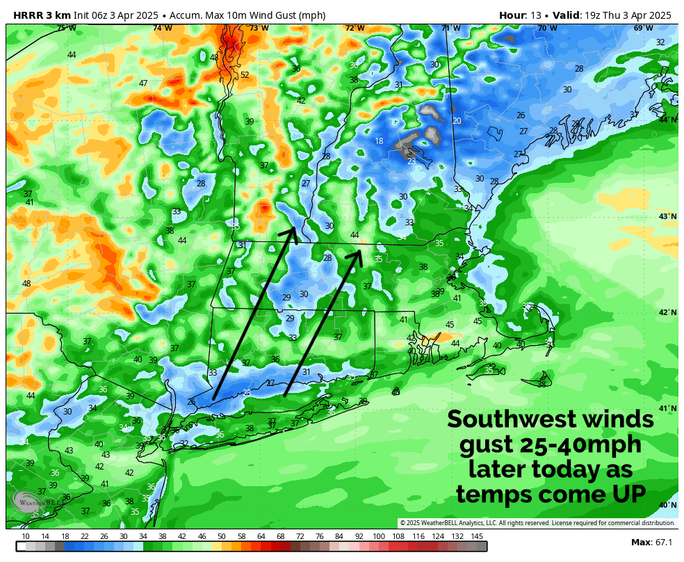
However, if we can get some sunny breaks for any length of time, we could shoot up over 70 degrees in spots, especially in the CT River Valley. In addition, southwest winds should pick up as warmer temps induce a low-level jet that passes nearby to mix some wind down, gusting 25-40mph at times.
As a cold works into the region tonight, a final broken line of showers may pass through from northwest to southeast, and lows should bottom out into the mid 30s to mid 40s as winds veer around to the northwest and gust to 25mph at times.
Friday looks quite nice as high pressure builds through to our north, with colder temps lagging the cold front, still reaching well into the 50s to low 60s for highs under partly sunny skies.
On Friday night, clouds will increase later as we cool down into the 30s for lows, getting ready for yet another warm-frontal precipitation finger, which is unlikely this time to produce icy pellets or glazes except MAYBE the highest mountains in SVT early Saturday night. We could also start as snow in the SVT mountains Saturday morning, or at least mix with it.
By mid to late morning on Saturday, rain showers should overspread the region, but with colder high pressure to our north, a raw and rainy day lies ahead to kick off the weekend, so more soup weather is incoming. Highs will only reach the 40s, maybe even upper 30s in SVT/SWNH, so plan accordingly. Showers at times continue Saturday night with lows in the mid 30s to low 40s.
By Sunday, our warm front moves through and while showers are still expected, at least temps should increase into the mid 50s to mid 60s.
Showers will wind down Sunday night with lows in the 30s as a cold front moves through the greater WMass region.
By Monday this should lower temps into the 40s to low 50s for highs under partly sunny skies with a few isolated showers possible.
We are more likely than not going to cool further Tuesday through mid-week, and a period of snow showers will be possible by Tuesday or Tuesday night, so I will keep you updated as we look to cool down next week and not just rocket into warmer temps.
Have a great day!
“Follow your bliss and the universe will open doors for you where there were only walls.”
― Joseph Campbell
