
TABLE OF CONTENTS
* Daily Celestials (Sun/Moon Data)
* Sponsor Section
* Morning Discussion
* TIP: Scroll to your section, or read more
~~~~~~~~~~~~~~~~~~~~~~
YOUR DAILY CELESTIALS
~~~~~~~~~~~~~~~~~~~~~~
STAR:
–OUR STAR ROSE AT: 6:47am this morning
–OUR STAR SETS AT: 7:06pm this evening
–TOTAL DAYLIGHT TIME: 12 hours and 19 minutes
MOON:
–OUR MOON SETS AT: 12:10pm this afternoon
–MOON SET DIRECTION: Southwest
–OUR MOON RISES AT: 4:21am tomorrow morning
–MOON RISE DIRECTION: Southeast
–MOON PHASE: Waning Crescent (40.1%)
~~~~~~~~~~~~~~~~~~~~~~
>>> A NOTE FROM OUR WEEKEND SPONSOR <<<
Dave Hayes The Weather Nut is Sponsored by Individual Community Members, Patrons, and Gerard, Ghazey & Bates, P.C.
GGBPC is a Northampton-based law firm and is the area’s premier estate and tax planning provider. The firm specializes in Estate Planning, Elder Law, and Tax Law, so be sure to contact GGBPC today to see how they can help you.
Simply click the following link to their secure website.
~~~~~~~~~~~~~~~~~~~~~~
YOUR MORNING DISCUSSION
~~~~~~~~~~~~~~~~~~~~~~
Good morning folks, anybody who lost power overnight should mostly have it restored by now, though there are a few hundred folks in Litchfield County CT still without power this morning.
Northwest winds came down a bit from their post-frontal peak overnight, but will still gust 15-30mph this morning, slackening by mid-day as high pressure moves east toward New England to weaken the pressure gradient.
It’s a cold start out there with temps in the teens and 20s, and some Berkshires and southwest VT wind chills in the single digits!!
A mostly sunny day lies ahead with highs reaching the 30s to low 40s, though some folks in SVT may only rise up to (or just below) the freezing mark, so it’ll feel like late winter today under mostly sunny skies.
For tonight, it’ll be clear early, and then we’ll cloud up. At the moment I don’t see much chance for an Aurora once we reach full darkness early tonight, but will try to keep an eye on that.
Lows tonight will dip into the upper teens to upper 20s, and it’ll be dry much of the night until about 4-6am Monday morning.
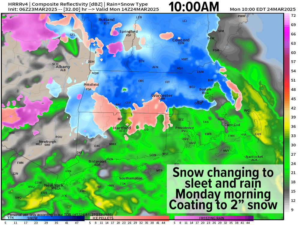
Early Monday morning, our warm frontal boundary extending off of a low center near Michigan will be spreading snowfall into the greater WMass region, and it may fall light to moderate in intensity at times, arriving mainly between 4:30am and 7:30am from west to east (Berkshires, Valley, Worcester/CMass).
Except for perhaps parts of southern VT and southwest NH along and especially north of its Route 9 corridor (not the MA route 9 corridor), milder air is expected to win out and flip any snow and sleet to sleet to rain by mid-morning to mid-day.
However, before that happens (with maybe the exception of the Springfield to Hartford lower valley stretch), light snow accumulations of a coating to 2” should fall and it may be enough to lower visibility a bit during het commute and provide for some slippery surfaces.
In addition, parts of far northwest MA, far northern CMass into SVT and SWNH at elevation could see more like 1-3” of snow, with isolated 4” amounts in the higher mountain areas where snow and sleet last into afternoon before either mixing with or changing to rain.
Highs Monday should reach the mid 30s to midi 40s with precip ending by dinner time, with a few mixed showers early in the evening as lows drop down into the mid 20s to mid 30s.
Tuesday through Thursday look mostly fair at this moment with highs generally in the upper 30s to upper 40s, and lows in the 20s to low 30s. There may be a few showers south of the Pike Wednesday, and a few more showers are possible Friday but for now these look like weak waves and nothing to get to uppity about.
For now, I’m gonna keep it focused on tomorrow morning’s minor wintry impact, and I hope you have a great day!
“Follow your bliss and the universe will open doors for you where there were only walls.”
― Joseph Campbell