
SECURELY BECOME A 2025
WEATHER NUT SUPPORTER TODAY
–> When 4% of readers support at any level,
this community weather resource remains active:
(Secure options include Cards, PayPal, Venmo, Check)
~~~~~~~~~~~~~~~~~~
TABLE OF CONTENTS
* Daily Celestials (Sun/Moon Data)
* Sponsor Section
* Morning Discussion
* TIP: Scroll to your section, or read all
~~~~~~~~~~~~~~~~~~~~~~
YOUR DAILY CELESTIALS
~~~~~~~~~~~~~~~~~~~~~~
STAR:
–OUR STAR ROSE AT: 6:44am this morning
–OUR STAR SETS AT: 5:24pm this evening
–TOTAL DAYLIGHT TIME: 10 hours and 40 minutes
MOON:
–OUR MOON RISES AT: 9:44pm tonight
–MOON RISE DIRECTION: East-Southeast
–OUR MOON SETS AT: 8:43am tomorrow morning
–MOON SET DIRECTION: West-Northwest
–MOON PHASE: Waning Gibbous (85.8%)
~~~~~~~~~~~~~~~~~~~~~~
>>> A NOTE FROM OUR WEEKEND SPONSOR <<<
Dave Hayes The Weather Nut is Sponsored by Individual Community Members, Patrons, and Gerard, Ghazey & Bates, P.C.
GGBPC is a Northampton-based law firm and is the area’s premier estate and tax planning provider. The firm specializes in Estate Planning, Elder Law, and Tax Law, so be sure to contact GGBPC today to see how they can help you.
Simply click the following link to their secure website.
~~~~~~~~~~~~~~~~~~~~~~
YOUR MORNING DISCUSSION
~~~~~~~~~~~~~~~~~~~~~~
Good morning folks, thanks for all of the snow reports this morning! It generally sounds like we ended up with 4-8” of snow across the region, with a few sub-4” amounts and a few 9-10” amounts, but generally in line with my thinking.
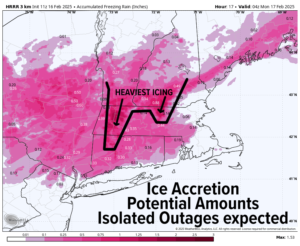
Now we’ve entered the more hazardous part of this storm system as we’ve transitioned mostly to sleet north (with some snow north of the Rt. 2 corridor or snow/sleet mix) and freezing rain south with milder air that is surged overhead to shut down snow production, while cold air damming from Maine southwest to the greater WMass region keeps surface temps plenty below freezing early this morning.
I also want to note that when it’s not actively precipitating today, freezing drizzle (where temps or at or below freezing) could cause additional icing/glazing at times, as the lower atmosphere is very saturated today with a potent storm located over western PA which will push northeast into NY and then redevelop overhead into the Gulf of Maine by this evening.
ICING THREAT INCREASES THIS AFTERNOON
Precipitation will become more showery later this morning and into afternoon, with the heaviest freezing rain and rain by early to mid-afternoon, which is when roads could become very treacherous in areas below freezing, ESPECIALLY the western hilltowns, eastern/northern Berkshire County, Franklin County, the northern half of Worcester County and SVT/SWNH, and possibly even in all of Hampshire County, which again is the battle zone between just-warm-enough air to create plain rain, or just cold enough for prolonged freezing rain and icing.
Highs will reach the upper 20s to mid 30s, and I do think we will see some plain rain into central/eastern Hampden County, southernmost Worcester County and northern CT from the Hartford Enfield stretch eastward, but I will be monitoring temps, as cold air is tough to scour out of the valley, a point I keep hammering on.
OUTAGES
The aforementioned areas (western hilltowns, eastern/northern Berkshire County, Franklin County, the northern half of Worcester County and SVT/SWNH) is where I am most concerned for Outage Round #1 (#2 comes tomorrow which could be worse).
Areas that receive a third up to half an inch (maybe a little more) of ice accretion on everything could see the weight of that ice break branches down onto power lines. It will be4come breezy this evening as well, and that will cause additional outages.
—————–
SECURELY BECOME A 2025
WEATHER NUT SUPPORTER TODAY
–> When 4% of readers support at any level,
this community weather resource remains active:
(Secure options include Cards, PayPal, Venmo, Check)
—————–
STREET FLOODING
In addition, when the heavier rain moves in today, with a moderate snowfall that preceded it and snow banks, snow/ice crumble etc., we’ll see street flooding and ponding, so if you are able to safely to do, clearing drains is optimal but if it’s too icy out, let it be!
Our storm will push into NY late this afternoon and then bomb-out into the Gulf of Maine tonight, backing our wind around from the west, with gusts picking up and blowing at speeds of 30-50mph possible overnight as the storm pulls east and away, which will cause more outages where icing was heaviest (in the high terrain).
Precipitation in any form should wrap up between 6-10pm from west to east, and may end as snow showers or sleet showers, getting gusty thereafter with lows dropping into the teens, and wind chills lower than that!
DAMAGING WIND FOR SOME
By Monday morning, our High Wind Warnings will be in full effect, and as the sun rises, and temps come up, the lower atmosphere will be well-mixed with a ripping low level jet streak overhead, which will produce westerly wind gusts of 40-65mph tomorrow, causing potentially numerous outages due to the wind alone, and in combination with snow and ice encasement from our weekend winter storm.
UPSLOPE AND LAKE EFFECT SNOW
Highs will reach the low to mid 20s, and we’ll see lake effect snow showers scattered about in the Berkshires, SVT, western hilltowns. We may even see a multi-lake effect band from Lakes Superior, Huron and Ontario reach through the valley and into CMass! And in addition, we’ll see some upslope snow overnight into Monday, with fresh light accumulations in the Berkshires, western hills and SVT.
WIND CHILLS BELOW ZERO
Monday night will see winds slacken a bit, but it will still be active with gusts of 20-40mph, and with lows crashing into the single digits, wind chills will go below zero at times!
THUSDAY SNOWSTORM POTENTIAL
Tuesday and Wednesday will feature fair but cold weather as our Arctic air settles into the region with highs in the low to mid 20s under partly sunny skies and lows in the single digits.
Again, I am continuing to monitor the Thursday snowstorm potential, but for now I think it would be a light snow impact for our region, and be more of a Cape Cod snowstorm with perhaps some moderate snowfall potential from Springfield south and east in southern MA and northern CT.
I know for a fact many enthusiasts, forecasters and even some meteorologists were bandying about huge 2-3 foot snow accumulation maps, which I personally think is misleading and clickbait-y at best and total BS at worst.
I will continue to monitor this potential, and a few other storm signals for the last week in February and keep you updated the whole way, so if you value my hyperlocal and interactive reporting work is helpful to you, you can chip in what you can at the link below to help support my work through 2025… thank you so much for your readership and support, Dave Hayes.
SECURELY BECOME A 2025
WEATHER NUT SUPPORTER TODAY
–> When 4% of readers support at any level,
this community weather resource remains active:
(Secure options include Cards, PayPal, Venmo, Check)
“Follow your bliss and the universe will open doors for you where there were only walls.”
― Joseph Campbell