
TABLE OF CONTENTS
* Daily Celestials (Sun/Moon Data)
* Sponsor Section
* Morning Discussion
* TIP: Scroll to your section, or read more
~~~~~~~~~~~~~~~~~~~~~~
YOUR DAILY CELESTIALS
~~~~~~~~~~~~~~~~~~~~~~
STAR:
–OUR STAR ROSE AT: 6:37am this morning
–OUR STAR SETS AT: 7:13pm this evening
–TOTAL DAYLIGHT TIME: 12 hours and 36 minutes
MOON:
–OUR MOON ROSE AT: 6:37am this morning
–MOON RISE DIRECTION: East
–OUR MOON SETS AT: 7:49pm tonight
–MOON SET DIRECTION: West
–MOON PHASE: New Moon (1.5%)
~~~~~~~~~~~~~~~~~~~~~~
>>> A NOTE FROM OUR WEEKEND SPONSOR <<<
Dave Hayes The Weather Nut is Sponsored by Individual Community Members, Patrons, and Gerard, Ghazey & Bates, P.C.
GGBPC is a Northampton-based law firm and is the area’s premier estate and tax planning provider. The firm specializes in Estate Planning, Elder Law, and Tax Law, so be sure to contact GGBPC today to see how they can help you.
Simply click the following link to their secure website.
~~~~~~~~~~~~~~~~~~~~~~
YOUR MORNING DISCUSSION
~~~~~~~~~~~~~~~~~~~~~~
Good morning folks, very complex forecast over the weekend as a frontal boundary bisects the greater WMass region from northwest to southeast and oscillates, ducks and weaves, undulates, and bobs south and north as it squiggles and wiggles (s l o w l y), causing massive temperature differences, and substantial impact differences in parts of our region.
To summarize, it’ll be milder today in north-central and northwest CT and far southwest MA (Springfield west to Great Barrington MA) and colder the further north and northeast you go, leading to temperature differences ranging from the low to mid 60s in northwest CT to the mid 30s in far northern MA and SVT/SWNH! It’ll even reach 80º in far southwest CT!
it’ll range in the upper 30s to low 50s from north to south across much of the WMass, CMass region, with low 50s to mid 60s in northern CT with a possible spike to the low 70s in southern Litchfield and southwest Hartford Counties.
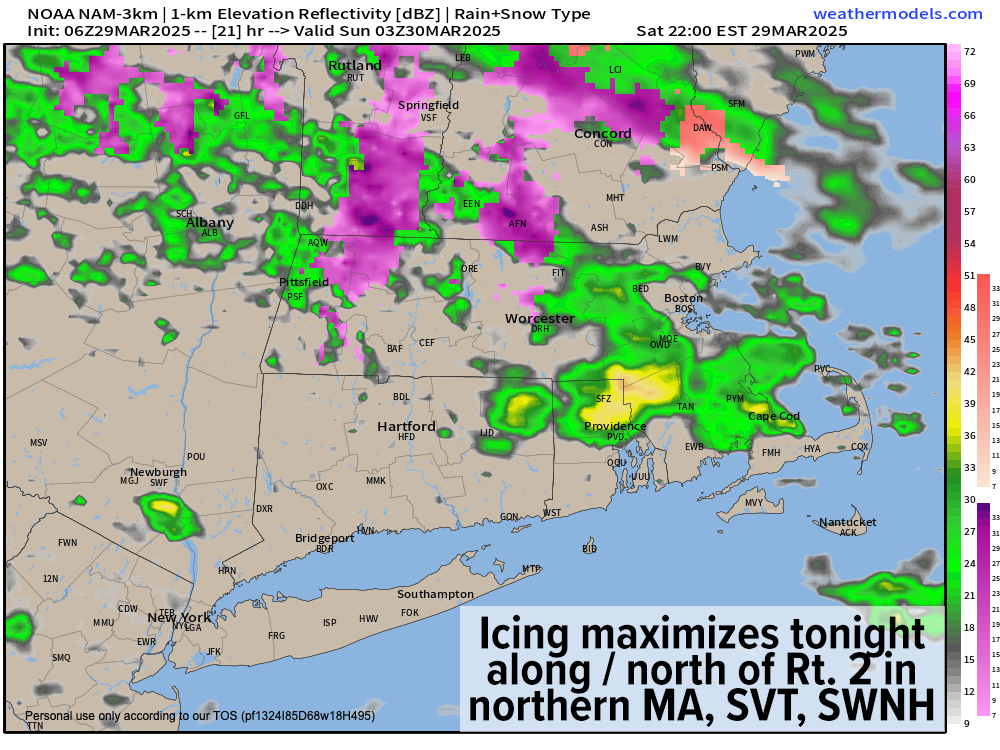
In addition, we can expect isolated to scattered showers of rain today, with maybe even a rumble of thunder along and south of the Pike in southern MA and northwest CT this afternoon. Drizzle is also possible, and some of this activity will be freezing onto surfaces in SVT and SWNH.
A Winter Storm warning continues for Cheshire County in SWNH, as this is the area of my coverage region that is closest to the cold air drain coming out of northeastern New England, keeping temps coldest tonight when icing is optimized in SWNH, SVT, and far northern MA.
As such, while Winter Weather Advisories continue for SVT, new Winter Weather Advisories have been hoisted for the northern Berkshires, Franklin County, western Hampshire County (hilltowns) and northern Worcester County for freezing rain, freezing drizzle and even freezing fog tonight through 11am Sunday morning.
After a mostly dry day today, shower activity will resume tonight as the front bobs south into southern CT pulling low temps into the low to mid 30s along and north of Route 2, and in the mid 30s to low 40s elsewhere with periods of rain south and freezing rain/drizzle north, where active icing will occur overnight.
In fact, by Sunday mid-day, we could see anywhere between a tenth to a quarter of an inch of ice in the northern Berkshires, northwest hilltowns, Franklin County, and northern Worcester County, with a quarter to half an inch of ice in SVT and SWNH, save for perhaps the Bennington VT area, where it should be a bit milder.
Sunday after the later morning period should become more dry than wet with highs in the upper 30s to mid 40s with occasional showers or drizzle.
By the nighttime, our warm front lifts northeast and through the region by Monday, pushing another round of rainfall through our region, and some final periods of icing may fall in the highest terrain of far northwest MA, northern CMass, and SVT/SWNH with lows in the low 30s to mid 40s from north to south.
On Monday, we “warm-sector” (a wacky hyphenated meteorological verb) whereby the warm front lifts well northeast through our entire region as low pressure tracks well northwest of us, pushing our highs into the upper 50s to 60s with a few scattered showers possible during the day. Southerly wind gusts may pick up to around 30mph or so.
Then at night, the cold front sweeps through and brings heavy rain at times with thunder possible overnight into early Tuesday morning.
Tuesday and Wednesday look to feature cooler, fair weather with highs in the 40s and lows in the 230s before we see another system bring icing late Wednesday night, turning to rain on Thursday with highs in the 50s, and possibly cresting 60º by Friday as we dry out.
Have a great day, I hope things go well for you today, and I will be staying on top of our weather all weekend with all of these wild seesaw changes as March goes out like a drunk on absinthe.
“Follow your bliss and the Universe will open doors for you where there were only walls.”
― Joseph Campbell