
TABLE OF CONTENTS
* Daily Celestials (Sun/Moon Data)
* Sponsor Note
* Morning Discussion
* TIP: Scroll below for sections, or read all
~~~~~~~~~~~~~~~
YOUR DAILY CELESTIALS
~~~~~~~~~~~~~~~~~~~~~~
STAR:
–OUR STAR ROSE AT: 6:22am this morning
–OUR STAR SETS AT: 7:23pm this evening
–TOTAL DAYLIGHT TIME: 13 hours and 1 minute
MOON:
–OUR MOON RISES AT: 2:11pm this afternoon
–MOON RISE DIRECTION: East-Northeast
–OUR MOON SETS AT: 4:39am tomorrow morning
–MOON SET DIRECTION: West-Northwest
–MOON PHASE: Waxing Gibbous (73.9%)
~~~~~~~~~~~~~~~~~~~~~~
A NOTE FROM OUR SPONSOR
~~~~~~~~~~~~~~~~~~~~~~
Dave Hayes The Weather Nut is Sponsored by Individual Community Members, Patrons, and Tandem Bagel Company… No matter the weather, Tandem Bagel is always there for you at several valley locations to make your mornings brighter! With *New Pizza Bagels(!)*, along with bagels baked fresh daily (including Gluten-Free options), house-whipped cream cheese, coffee, and tons of lunch options, Tandem is the perfect quick stop for lunch, breakfast, or a coffee and bagel to go.
You can either 1) visit them in Easthampton, Northampton, Hadley, Florence, and/or West Springfield, 2) hire them to cater your next event, or 3) use their super-streamlined online ordering tool by visiting their website and clicking the “Catering” or “Order Online” links.
~~~~~~~~~~~~~~~~~~~~~~
YOUR MORNING DISCUSSION
~~~~~~~~~~~~~~~~~~~~~~
Good morning everybody, light snow, sleet and rain is ongoing across the region this morning with mild-enough in the central and southern valley through much of northern CT and the southern two-thirds of CMass to produce rain, with high terrain mix or snow.
The precip shield has a more mottled, uneven look to it, so this doesn’t inspire tons of confidence for coatings of snow into the valley, where I think rain or mix will dominate today.
A coating to an inch or two is expected in the high terrain today of WMass, northern CMass, SVT and SWNH, and we may see a second burst of precipitation by mid-afternoon with cooler air slowly developing.
In this second burst I will be looking at eastern Franklin County into the northern half of Worcester County up into SWNH where some fresh coatings could form for some late in the afternoon.
In any heavier bursts of precip, we could see rainy areas mix with or briefly turn to snow or sleet at times, even in the valley.
Highs today should pretty much be where they are now for many of us, mid 30s to low 40s (even though northwest MA and SVT are in the upper 20s to low 30s currently).
For tonight, we start to dry out before the cold front moves in early Tuesday morning. Some patchy drizzle is possible, and if that forms, could cause some slick spots in the high terrain.
Low pressure well south of us will pull east and out to sea and lows will drop into the mid 20s to low 30s with our upper low and cold front approaching from the west.
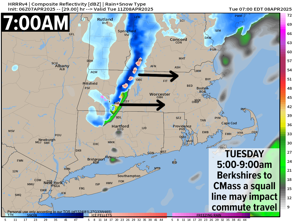
Between 5-9am from the Berkshires to eastern Worcester County (Fitchburg / Worcester) a squall line will try to form and should it do so, a brief period of heavier snow or mixed precip is possible that could lower visibility during prime morning commute time and also dust the ground in the high terrain west of the I-91 corridor and/or in the Worcester hills, so that is something to be aware of.
There will also be some upslope snow showers forming in the northern Berkshires into SVT, and a fresh coating to an inch may accumulate there by Tuesday night.
Regardless of today or tomorrow’s minor snow accumulations, it is the developing wintry, blustery and cold Tuesday with gusts of 30-50mph by afternoon and wind chills taking a nosedive into the teens and 20s that will be our main weather story for the week.
Highs will only reach the upper 20s to upper 30s under a mixed sky, again with wind chills by afternoon in the teens at times, with lows Tuesday night crashing into the upper teens to mid 20s, which is quite cold for the 2nd week of April.
Wednesday will feature breezy conditions with gusts up to 30mph out of the west, but it should be drier and more sunny with highs in the mid 30s to mid 40s as high pressure noses through the region. Lows will dip into the low to mid 20s for one last cold night as our upper trough swings through and east of our region, allowing southerly flow by late week, along with milder temps.
With that southerly flow will come more rain chances, including Thursday night into Friday morning, Friday night into Saturday morning and again on Sunday!
Thursday does look like the pick of the week right now with highs in the 40s to low 50s under partly to mostly sunny skies, but clouds will be increasing by afternoon and some mix of snow/rain in the high terrain and rain showers in the valley points south and east moves in Thursday night with a small disturbance, winding down by Friday morning.
We get a brief break with highs in the mid 40s to mid 50s, then a bigger system moves in Friday evening into the overnight with more rainfall into at least the first part of Saturday.
Sunday may feature another system as well, but much uncertainty lies that far out so I will update as get closer.
Have a great day!
“Follow your bliss and the universe will open doors for you where there were only walls.”
― Joseph Campbell