
TODAY’S NUTSHELL: A weak but juicy low pressure system will be slowly sliding east-northeast of the New Jersey coast line and hugging southernmost New England as it lollygags east through southeast MA and out into the Gulf of Maine by Saturday. Rainfall already into the Berkshires, Litchfield County and SVT will slowly translate east through the rest of the greater WMass region by early afternoon. Rain continues tonight, tapering to showers early on Saturday, followed by gusty, drying conditions in the afternoon. Warmer and sunnier times are ahead Sunday through Tuesday, with a few showers by mid-week.
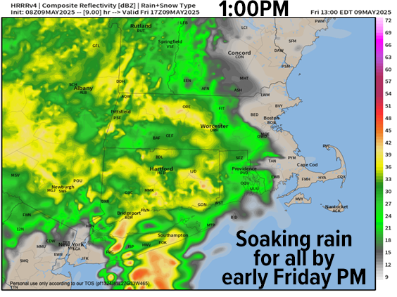
TABLE OF CONTENTS
* Daily Celestials (Sun/Moon)
* Sponsor Section
* Your Short-Term ZoneCast
* Morning Discussion
~~~~~~~~~~~~~~~
YOUR DAILY CELESTIALS
~~~~~~~~~~~~~~~~~~~~~~
STAR:
–OUR STAR ROSE AT: 5:35am this morning
–OUR STAR SETS AT: 7:58pm this evening
–TOTAL DAYLIGHT TIME: 14 hours and 23 minutes
MOON:
–OUR MOON RISES AT: 5:19pm this afternoon
–MOON RISE DIRECTION: East-Southeast
–OUR MOON SETS AT: 4:19am tomorrow morning
–MOON SET DIRECTION: West-Southwest
–MOON PHASE: Waxing Gibbous (84.7%)
~~~~~~~~~~~~~~~~~~~~~~
A NOTE FROM OUR SPONSOR
~~~~~~~~~~~~~~~~~~~~~~
Dave Hayes The Weather Nut is Sponsored by Individual Community Members, Patrons, and Tandem Bagel Company… No matter the weather, Tandem Bagel is always there for you at several valley locations to make your mornings brighter! With *New Pizza Bagels(!)*, along with bagels baked fresh daily (including Gluten-Free options), house-whipped cream cheese, coffee, and tons of lunch options, Tandem is the perfect quick stop for lunch, breakfast, or a coffee and bagel to go.
You can either 1) visit them in Easthampton, Northampton, Hadley, Florence, and/or West Springfield, 2) hire them to cater your next event, or 3) use their super-streamlined online ordering tool by visiting their website and clicking the “Catering” or “Order Online” links.
~~~~~~~~~~~~~~~~~~~~~~
YOUR SHORT-TERM ZONECAST
~~~~~~~~~~~~~~~~~~~~~~
ZONE 1 – Northern Region
(Southern VT, Southwest NH)
–Highs Today: Upper 40s to Mid 50s
–Lows Tonight: Mid 40s
–Highs Tomorrow: Mid to Upper 50s
–Winds: Light east today and tonight, west-northwest gusting 20-35mph tomorrow
–Skies: Overcast today, tonight, and tomorrow morning, but sunny periods by afternoon
–Precip: Rain today and tonight, a few showers Saturday morning
–NWS Alerts + Nut Notes: Flood Watches are active
ZONE 2 – Central Region
(Western MA, North-Central MA, Northern Litchfield CT)
–Highs Today: Upper 40s to Mid 50s
–Lows Tonight: Mid to Upper 40s
–Highs Tomorrow: Upper 50s to Low 60s
–Winds: Light east today and tonight, west-northwest gusting 20-35mph tomorrow
–Skies: Overcast today, tonight, and tomorrow morning, but sunny periods by afternoon
–Precip: Rain today and tonight, a few showers Saturday morning
–NWS Alerts + Nut Notes: Flood Watches are active, Flood Warnings for CT River at Montague and Northampton more likely than not to be hoisted later
ZONE 3 – Southern Region
(South-Central MA, Northern CT)
–Highs Today: Mid 50s to Low 60s
–Lows Tonight: Upper 40s
–Highs Tomorrow: Low to Mid 60s
–Winds: Light east today and tonight, west-northwest gusting 20-35mph tomorrow
–Skies: Overcast today, tonight, and tomorrow morning, but sunny periods by afternoon
–Precip: Rain today and tonight, a few showers Saturday morning
–NWS Alerts + Nut Notes: Flood Watches are active, Flood Warnings for CT River at Thompsonville likely to be hoisted… Flood Warnings at Hartford continue
~~~~~~~~~~~~~~~~~~~~~~
YOUR MORNING DISCUSSION
~~~~~~~~~~~~~~~~~~~~~~
Good morning folks, another rainstorm is on the way and with copious amounts of rain already received over the past 7 days, the Connecticut River is looking likely to flood at minor stage, and possibly moderate stage at Northampton when it’s forecast to crest to 114 feet or so by Sunday morning.
Currently, rain has already resumed in far western parts of the greater WMass region (Litchfield County CT, Berkshire County MA and SVT), and that whole mass of sky water will slowly translate east as it travels from southwest to northeast.
It will be a cool and raw, rainy day with a light east wind and highs only in the upper 40s to 50s, possibly cooling a bit in the afternoon as the rain fills into our region by noon or early afternoon from west to east.
For tonight, more rain is expected, and we should see totals by Saturday noon around 1-3” of additional rain. There could be some higher amounts in the western hilltowns or Worcester highlands where orographic effects will ring out some more moisture.
Lows will drop into the 40s for most of us, so gear up if you are headed out and about.
By Saturday morning, a dry slot will be working towards our region as the low center tracks east-northeast and away from us. However, some wraparound scattered showers are likely to form in the morning before west-northwest winds on the back side of the system pick and clear things out later in the afternoon.
West-northwest gusts of 20-35mph are expected tomorrow afternoon, and we should develop a mixed sky with some sunny breaks as drier air works into the region.
For Saturday night, we should clear right out and see low drop into the 40s for most of us, with some upper 30s in the SVT mountain peaks.
Once we get to Sunday, our reward for enduring this long rainy slog arrives!
High pressure will be building in from the northwest, and create a sunny day with slackening wind, and highs in the 60s with lows either side of 40º under clear skies.
As high pressure dives southeast through New England and positions south of us, we’ll develop southerly flow and warming temps, with sunny skies expected Monday and Tuesday with highs ono Monday in the low to mid 70s, and by Tuesday in the mid 70s to low 80s! Lows will hang in the 50s both nights.
By Wednesday, we’ll remain warm and in the 70s for highs, but clouds may start to build ahead of a fairly anemic-looking frontal boundary which may bring some showers to our region Wednesday night into Thursday.
However, that’s a long way off, so I say let’s focus on the Saturday afternoon to Tuesday Drying-and-Sunnification Zone of Happiness! #DASZOH
Have a great day!
“Follow your bliss and the universe will open doors for you where there were only walls.”
― Joseph Campbell