
TODAY’S NUTSHELL: A strong and deepening low pressure system is running northward into WMass later today, and will push periods of rain, sometimes heavy, through the region. Thunder is also possible. A lull is expected by mid to late morning where we see a bit more in the way of scattered showers with some dry periods or drizzle, but another wraparound period of rain moves in this afternoon before the storm lifts north and away tonight. A nicer Sunday is on the way to close out the weekend, and more sun and warming temps are expected next week, with very warm temps by late week and increased humidity. This may spawn some showers and thunderstorms Thursday night into Friday.
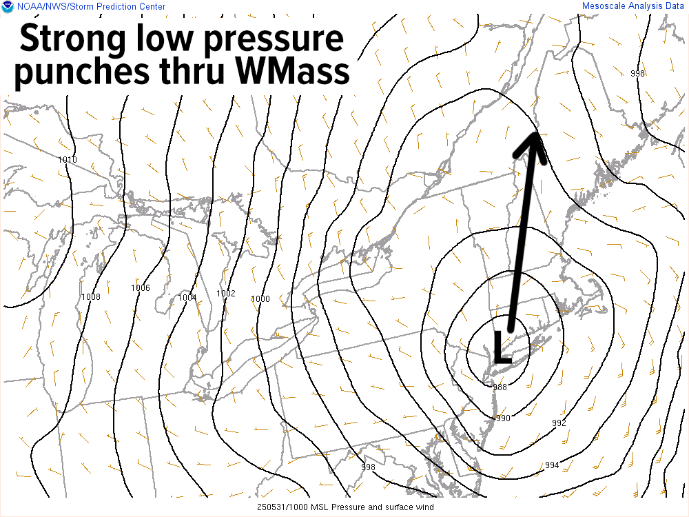
TABLE OF CONTENTS
* Daily Celestials (Sun/Moon Data)
* Sponsor Section
* Morning Discussion
~~~~~~~~~~~~~~~~~~~~~~
YOUR DAILY CELESTIALS
~~~~~~~~~~~~~~~~~~~~~~
STAR:
–OUR STAR ROSE AT: 5:17am this morning
–OUR STAR SETS AT: 8:19pm this evening
–TOTAL DAYLIGHT TIME: 15 hours and 2 minutes
MOON:
–OUR MOON RISES AT: 9:45am this morning
–MOON RISE DIRECTION: Northeast
–OUR MOON SETS AT: 12:45am tomorrow morning
–MOON SET DIRECTION: West-Northwest
–MOON PHASE: Waxing Crescent (23.6%)
~~~~~~~~~~~~~~~~~~~~~~
>>> A NOTE FROM OUR WEEKEND SPONSOR <<<
Dave Hayes The Weather Nut is Sponsored by Individual Community Members, Patrons, and Gerard, Ghazey & Bates, P.C.
GGBPC is a Northampton-based law firm and is the area’s premier estate and tax planning provider. The firm specializes in Estate Planning, Elder Law, and Tax Law, so be sure to contact GGBPC today to see how they can help you.
Simply click the following link to their secure website.
~~~~~~~~~~~~~~~~~~~~~~
YOUR MORNING DISCUSSION
~~~~~~~~~~~~~~~~~~~~~~
Good morning everybody, deluge at dawn it has been! We now have a final (for now) area of showers and downpours with some embedded thtunder working north through the greater WMass region with Flood Advisories up for eastern Windham County VT and southwest Cheshire County NH with potential for street flooding there, as well as the region in general, especially into the western hilltowns and Berkshires.
A potent low center is attaining the depth of a strong winter storm, which is quite unusual as we end the merry (soggy?) month of May. This storm will lift north right through the CT River Valley later today.
Because of that, the heaviest rain is now setting up northwest and west of that low center in New York state as the last of our initial heavy rain round is lifting into northern CT as I write this report.
Consequently, a dry slot should push into our region by mid to late morning behind this final shower/downpour round, with isolated to scattered showers or drizzle possible with dry periods into early to mid afternoon.
Highs today will reach the low to mid 60s, and another wraparound round of showers with a thunderstorm or two should sweep west to east or southwest to northeast UNDER the low center as it tracks north.
This activity should move through our region between about 2-10pm, roughly, and may even be done by 8pm.
After that final batch of rainfall, conditions should improve later tonight with lows dropping into the mid to upper 40s. Many of us will have picked up another 1-2” of rain.
Despite a few isolated showers tomorrow, Sunday is much improved with highs reaching the low to mid 60s once again, but this time under partly sunny skies and breezy westerly winds. Lows again will be in the 40s.
The Monday through Thursday period looks to feature mostly sunny skies and warming temps, especially by mid-week when we could climb well into the 80s, such that by Thursday I’ll watching a cold front coming toward the region, which may spark some notable showers, downpours and thunderstorms for Thursday evening into Friday.
I will update later today on that anticipated second round of showers this afternoon. Enjoy your coffee, tea, or other beverage of choice this morning.
Have a great day!
“Follow your bliss and the Universe will open doors for you where there were only walls.”
― Joseph Campbell