
YOUR NUTSHELL: We’re going to see humidity creep north this afternoon which will set up a boundary along which a few showers or even a thunderstorm will fire this afternoon. It’ll be warmer in the 70s with low pressure bringing a widespread, heavier rainfall later tonight into at least the first half of Saturday before it lifts north. Scattered showers Saturday evening/night beget a nicer Sunday with partly sunny skies. If all goes as expected, next week looks sunnier and warmer, with the low probability for a cloudier and cooler setup, especially well east of the I-91 corridor.
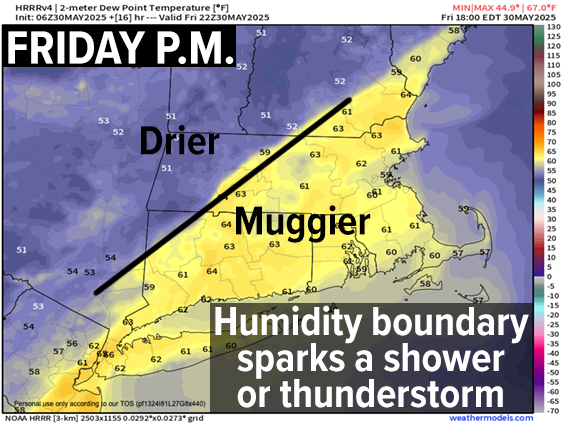
TABLE OF CONTENTS
* Daily Celestials (Sun/Moon)
* Sponsor Section
* Morning Discussion
~~~~~~~~~~~~~~~
YOUR DAILY CELESTIALS
~~~~~~~~~~~~~~~~~~~~~~
STAR:
–OUR STAR ROSE AT: 5:17am this morning
–OUR STAR SETS AT: 8:18pm this evening
–TOTAL DAYLIGHT TIME: 15 hours and 1 minute
***15 HOURS OF DAYLIGHT TODAY!!!***
MOON:
–OUR MOON RISES AT: 8:30am this morning
–MOON RISE DIRECTION: Northeast
–OUR MOON SETS AT: 12:14am tonight
–MOON SET DIRECTION: West-Northwest
–MOON PHASE: Waxing Crescent (15.0%)
~~~~~~~~~~~~~~~~~~~~~~
A NOTE FROM OUR SPONSOR
~~~~~~~~~~~~~~~~~~~~~~
Dave Hayes The Weather Nut is Sponsored by Individual Community Members, Patrons, and Tandem Bagel Company… No matter the weather, Tandem Bagel is always there for you at several valley locations to make your mornings brighter! With *New Pizza Bagels(!)*, along with bagels baked fresh daily (including Gluten-Free options), house-whipped cream cheese, coffee, and tons of lunch options, Tandem is the perfect quick stop for lunch, breakfast, or a coffee and bagel to go.
You can either 1) visit them in Easthampton, Northampton, Hadley, Florence, West Springfield, and/or Ludlow, 2) hire them to cater your next event, or 3) use their super-streamlined online ordering tool by visiting their website and clicking the “Catering” or “Order Online” links.
~~~~~~~~~~~~~~~~~~~~~~
YOUR MORNING DISCUSSION
~~~~~~~~~~~~~~~~~~~~~~
Good morning folks, we’re starting off with mostly cloudy skies and temps in the 50s to low 60s with patchy fog in spots, notably dense in Westfield, MA.
Fog should evaporate later this morning as high temps are expected to rise into the low to mid 70s as partly sunny skies develop with a brief bit of upper ridging that gives way to our incoming storm system overnight into Saturday that runs north right through WMass/CMass tomorrow.
Before our rainstorm, however, humidity will be building from the south today which should form a frontal boundary along which we should see some isolated to scattered showers or even a few thunderstorms later this Friday afternoon, so something to be aware of.
That activity will die out later this evening, with lows dropping into the mid to upper 50s, but right on its heels will be our incoming storm system that will push some showers in here between 10pm-2am.
However, it’s in the later pre-dawn hours into Saturday morning that the heaviest rain arrives, and this system does look juicier today as compared to yesterday’s outlook. In fact, some areas of western MA up into SVT could see over 2” of rainfall from this system. Thunder is also possible, along with areas of street flooding on Saturday, especially in the morning.
The good news is this is a fast-moving, progressive system that will track south-southwest to north-northeast through our region up into northern New England by afternoon, so we should see a fairly fast tapering off of rain sometime either side of noon.
Highs tomorrow will reach the mid to upper 60s, and some additional showers are possible by late afternoon and evening, especially south of the Pike as a second storm tries to fire up and pass near the Cape, spawned by a wave wrapping round our departing low pressure system.
Lows Saturday night will dip into the 45-50º range, with highs in the low to mid 60s on Sunday under partly sunny skies with a couple of spot showers possible. Lows Sunday night dip into the 40s.
AS of this writing the greatest probability for next week is partly to mostly sunny skies with a ridge of high pressure building into the region and pumping highs well into the 70s with a few low 80s possible.
However, there is a low chance that our upper trough doesn’t escape out to sea as quickly, which could prolong some cloudiness and cooler temps. For now I think the warmth, sun and high pressure will win out, but I’ll be sure to keep you updated!
Have a great day, and may good things come your way!
“Follow your bliss and the universe will open doors for you where there were only walls.”
― Joseph Campbell