
TODAY’S NUTSHELL: High pressure is fleeting today as a warm front and low pressure along that front advances northeast towards New England. Any partial sunshine ths morning gives way to mostly cloudy skies later today and tonight. A few showers arrive before midnight, but most of the rain holds off until the pre-dawn hours of Thursday morning, lasting into early to mid-afternoon with cooler high temps. A spot shower or thunderstorm gives way to more rainfall for Saturday into the evening before high pressure tracks into New England early to middle of next week with increasingly warm temps and sunny skies. Sunday looks like the weekend pick for sure!
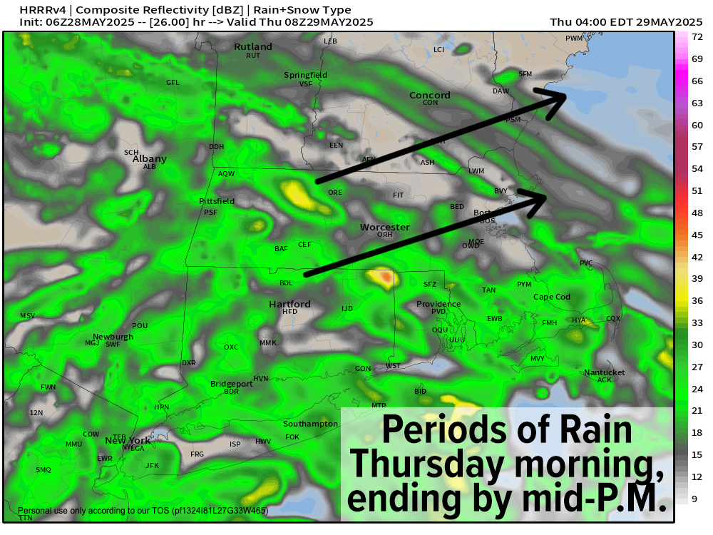
TABLE OF CONTENTS
* Daily Celestials (Sun/Moon)
* Sponsor Section
* Morning Discussion
~~~~~~~~~~~~~~~
YOUR DAILY CELESTIALS
~~~~~~~~~~~~~~~~~~~~~~
STAR:
–OUR STAR ROSE AT: 5:18am this morning
–OUR STAR SETS AT: 8:16pm this evening
–TOTAL DAYLIGHT TIME: 14 hours and 58 minutes
MOON:
–OUR MOON ROSE AT: 6:09am this morning
–MOON RISE DIRECTION: Northeast
–OUR MOON SETS AT: 10:43pm tonight
–MOON SET DIRECTION: Northwest
–MOON PHASE: Waxing Crescent (2.8%)
~~~~~~~~~~~~~~~~~~~~~~
A NOTE FROM OUR SPONSOR
~~~~~~~~~~~~~~~~~~~~~~
Dave Hayes The Weather Nut is Sponsored by Individual Community Members, Patrons, and Tandem Bagel Company… No matter the weather, Tandem Bagel is always there for you at several valley locations to make your mornings brighter! With *New Pizza Bagels(!)*, along with bagels baked fresh daily (including Gluten-Free options), house-whipped cream cheese, coffee, and tons of lunch options, Tandem is the perfect quick stop for lunch, breakfast, or a coffee and bagel to go.
You can either 1) visit them in Easthampton, Northampton, Hadley, Florence, and/or West Springfield, 2) hire them to cater your next event, or 3) use their super-streamlined online ordering tool by visiting their website and clicking the “Catering” or “Order Online” links.
~~~~~~~~~~~~~~~~~~~~~~
YOUR MORNING DISCUSSION
~~~~~~~~~~~~~~~~~~~~~~
Good morning folks, we’ve got a lovely albeit cool start to the day ongoing with temps in the upper 40s to low 50s under partly to mostly sunny skies, although clouds will be building through the day as high pressure’s influence on us wanes as it retreats out to sea to our east.
Highs today will climb into the low to mid 70s, but not any higher as clouds put the tamp-down on today’s temps.
While a few showers may work into the region this evening, I think we stay mostly cloudy and dry, but after midnight it should morph into a different story.
A warm front will be advancing northeast with weak low pressure along it, which will push periods of rainfall into our region mostly after midnight and through Thursday morning, departing by early to mid-afternoon.
Lows tonight will dip into the low to mid 50s and highs Thursday will only reach the low to mid 60s within a cool showery regime. We dry out a bit Thursday night, with lows dipping into the mid 50s.
By Friday, we should enjoy a pop in temps with highs in the low to mid 70s under partly sunny skies with an isolated shower or thunderstorm or two in the afternoon. Clouds will increase at night with more rain developing late as lows bottom out into the 50s.
For Saturday, yet another coastal low pressure system will be spawned over the Mid-Atlantic region by yet another upper low trough swinging into the northeast U.S.
Please don’t hurl rotten tomatoes at the nut!
Saturday will definitely NOT be the weekend pick, unless you like doing mud angels in cool temps with your mouth agape to catch multiple liquid hydrometeors!
Highs will be well into the 60s, and we’ll taper to showers Saturday night as low pressure runs northeast right through the gut of southern New England. Lows will dip to the 50s.
By Sunday, that storm will be long gone to our northeast, and we should see partly to mostly sunny skies develop with a spot instability shower possible. Highs will again reach well into the 60s with northwest breezes, and lows will dip to the 40s.
If you like warmth, sunshine and high pressure days, our weather will continue to improve through the week with no real rainy signals, and high pressure building in from the west, and eventually settling southeast of us by mid to late week which may drive some early summer warmth into the region.
II would not be surprised to see some low u80s for highs by next Wednesday through Friday!
Have a great day, and may good things come your way!
“Follow your bliss and the universe will open doors for you where there were only walls.”
― Joseph Campbell