
TODAY’S NUTSHELL: The upper low that has been producing so much unsettled weather as of late is now located firmly east of New England over Atlantic Canada, but we still feel its influence for one more day as it sends a weak wave northwest to southeast through the region with scattered showers this afternoon. Despite an isolated shower or two mostly east of I-91 on Memorial Day, we should see more sunshine that persists into the middle of this upcoming week. After that, another round of showers and possibly thunderstorms may pay us a visit during the Thursday to Saturday timeframe.
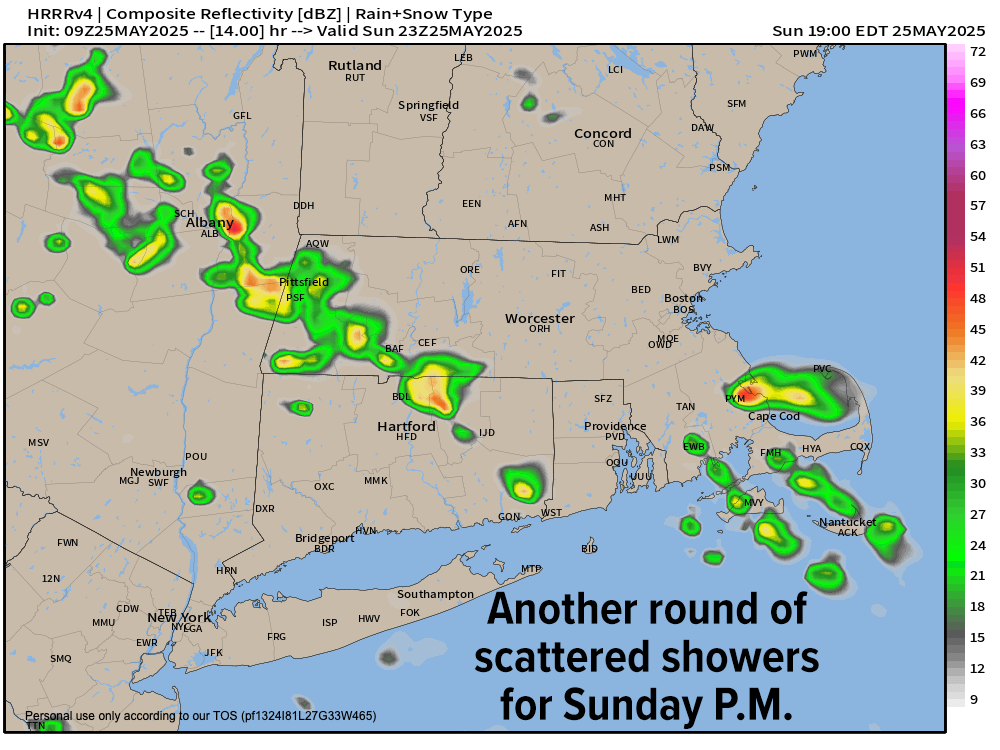
TABLE OF CONTENTS
* Daily Celestials (Sun/Moon Data)
* Sponsor Section
* Morning Discussion
~~~~~~~~~~~~~~~~~~~~~~
YOUR DAILY CELESTIALS
~~~~~~~~~~~~~~~~~~~~~~
STAR:
–OUR STAR ROSE AT: 5:20am this morning
–OUR STAR SETS AT: 8:14pm this evening
–TOTAL DAYLIGHT TIME: 14 hours and 54 minutes
MOON:
–OUR MOON SETS AT: 6:55pm this afternoon
–MOON SET DIRECTION: West-Northwest
–OUR MOON RISES AT: 4:27am tomorrow morning
–MOON RISE DIRECTION: East-Northeast
–MOON PHASE: Waning Crescent (4.3%)
~~~~~~~~~~~~~~~~~~~~~~
>>> A NOTE FROM OUR WEEKEND SPONSOR <<<
Dave Hayes The Weather Nut is Sponsored by Individual Community Members, Patrons, and Gerard, Ghazey & Bates, P.C.
GGBPC is a Northampton-based law firm and is the area’s premier estate and tax planning provider. The firm specializes in Estate Planning, Elder Law, and Tax Law, so be sure to contact GGBPC today to see how they can help you.
Simply click the following link to their secure website.
~~~~~~~~~~~~~~~~~~~~~~
YOUR MORNING DISCUSSION
~~~~~~~~~~~~~~~~~~~~~~
Good morning everybody, we’re starting off our Sunday in the 40s to low 50s with a few light showers in the Berkshires this morning, but most of us are on the dry side. The pesky upper low center that helped spawn that soaking rainstorm / nor’easter Thursday is *finally* east of New England and drifting east through Atlantic Canada and headed out of our lives #BuhBye.
Still, wouldn’t you know it (and lucky us) there is one last weak wave that will be drawn southeast through the greater WMass region as it chases that upper low to catch up with it like a duckling that’s waddling to catch up with mama.
So after a day with partly sunny to mostly cloudy skies, we should see some scattered showers pop again this afternoon, probably by mid-afternoon into the early evening.
Highs should be a bit milder, reaching the low to midi 60s for highs with some gusts to 15-20mph and lows in the 40s with any showers winding down.
Memorial Monday will be the pick of the long weekend with partly to mostly sunny skies and only a spot shower likely, while most of us remain dry. Highs will reach the upper 60s to low 70s, with lows in the 40s to near 50º.
And if Monday is our long weekend pick, Tuesday is our weekly pick with plenty of sunshine as high pressure builds overhead with highs reaching the low to mid 70s with a light breeze, and lows bottoming out into the low 50s.
By Wednesday, another warm day awaits with highs again in the low to mid 70s, but clouds will start building back into the region with time.
Another area of disturbed weather will be gathering to our west, and while temps do not look like they will cool to unseasonably and anomalously low levels like we just witnessed, we may be dealing with more scattered showers and/or thunderstorms sometime within that Thursday to Saturday timeframe with high temps in and around the upper 60s to 70s, so at least that’s some good news, right? RIGHT?!
Come on people now, smile on your Nutter, everybody get together and love next week’s weather right now. #TheYoungbloods
Have a great day!
“Follow your bliss and the Universe will open doors for you where there were only walls.”
― Joseph Campbell