
TODAY’S NUTSHELL: We continue to reside under the influence of our an upper low that’s now aloft over New England and will start pulling east and out to sea. Mostly light morning showers evident over northern MA, the Berkshires, SVT and SWNH will slowly transition into isolated to scattered pop-up showers by this afternoon and early evening. Temps will be rising through the weekend, ending with some folks touching 70º on Memorial Day, which will be the weekend pick. We continue to warm into mid-week before more showers are possible late week.
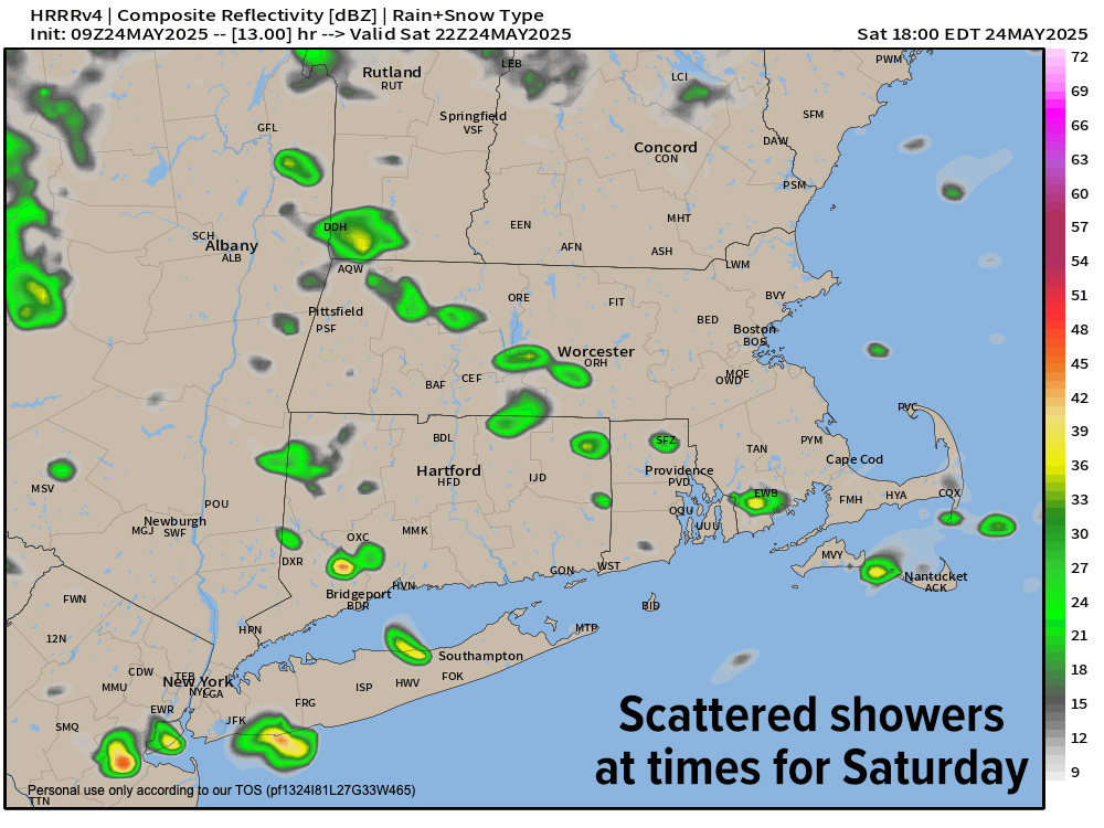
TABLE OF CONTENTS
* Daily Celestials (Sun/Moon Data)
* Sponsor Section
* Morning Discussion
~~~~~~~~~~~~~~~~~~~~~~
YOUR DAILY CELESTIALS
~~~~~~~~~~~~~~~~~~~~~~
STAR:
–OUR STAR ROSE AT: 5:21am this morning
–OUR STAR SETS AT: 8:13pm this evening
–TOTAL DAYLIGHT TIME: 14 hours and 52 minutes
MOON:
–OUR MOON SETS AT: 5:31pm this afternoon
–MOON SET DIRECTION: West-Northwest
–OUR MOON RISES AT: 3:52am tomorrow morning
–MOON RISE DIRECTION: East-Northeast
–MOON PHASE: Waning Crescent (10.4%)
~~~~~~~~~~~~~~~~~~~~~~
>>> A NOTE FROM OUR WEEKEND SPONSOR <<<
Dave Hayes The Weather Nut is Sponsored by Individual Community Members, Patrons, and Gerard, Ghazey & Bates, P.C.
GGBPC is a Northampton-based law firm and is the area’s premier estate and tax planning provider. The firm specializes in Estate Planning, Elder Law, and Tax Law, so be sure to contact GGBPC today to see how they can help you.
Simply click the following link to their secure website.
~~~~~~~~~~~~~~~~~~~~~~
YOUR MORNING DISCUSSION
~~~~~~~~~~~~~~~~~~~~~~
Good morning everybody, I hope your sleep bestowed upon you a deep rest. As for our weather, we continue to live under the influence of a weakening upper low pressure system that’s been blocked from kicking out of here quickly.
Today should be the last full day of influence from this system, and we’re already seeing morning showers and periods of lighter rain in the Berkshires, northern MA, on up into SVT and parts of SWNH.
Highs today will only reach the upper 50s to perhaps 60º with mostly cloudy skies persisting, and some isolated to scattered pop-up showers will develop into the afternoon and early evening. Lows should bottom out in the low to mid 40s with a few showers possible.
For Sunday, our upper low will be centered over Atlantic Canada which will allow for at least some partial sunshine to develop, though some isolated showers are expected. Highs will be milder, climbing into the low to mid 60s, with lows in the mid to upper 40s.
Memorial Day Monday is clearly the pick of the long weekend with partly to mostly sunny skies expected as high pressure builds in from the west, helping to produce more seasonal highs either side of 70º. A spot shower is possible over the high terrain, but we should be mostly dry, with lows bottoming out into the mid to upper 40s as we clear out.
Tuesday and Wednesday look even warmer with highs rising into low to mid 70s as high pressure dominates New England ahead of an incoming showery period for late week, starting with Thursday.
The late-week period doesn’t look like a washout or very substantial, but some showers will be possible again as a system tries to makes its way into the northeast U.S. Regardless of how that plays out, temps should remain at seasonable levels, somewhere either side of the low 70s for highs.
Have a great day!
“Follow your bliss and the Universe will open doors for you where there were only walls.”
― Joseph Campbell