
TODAY’S NUTSHELL: As our surface low pushes into the Gulf of Maine we’ll see some upslope showers over the Berkshires and southwest VT, otherwise activity decreases this morning. However, as the storm pulls north it will wrap around more showers back into the greater WMass region by mid to late afternoon and evening, with some showers on/off overnight into Saturday morning. We’ll be cool today and tomorrow, and then high pressure pushes closer for Sunday and Monday when sunshine and temps will increase. A few showers are possible by mid-week, with a greater storm chance for late next week.
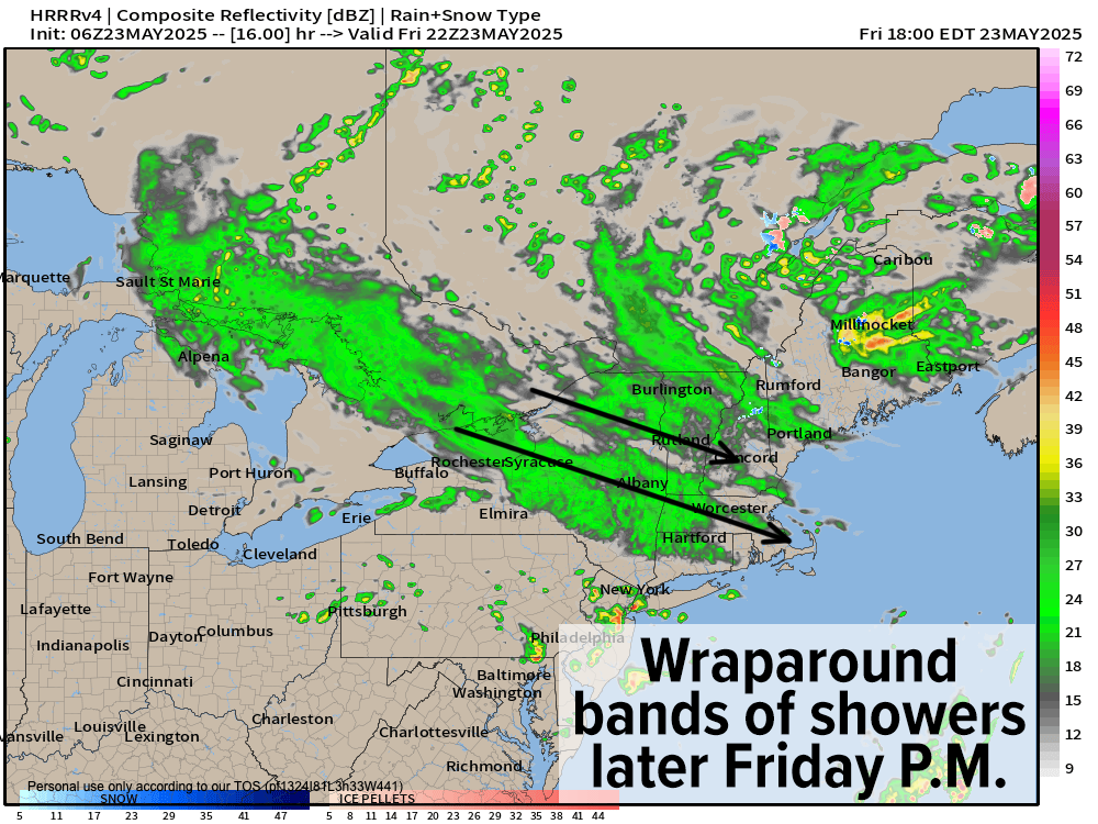
TABLE OF CONTENTS
* Daily Celestials (Sun/Moon)
* Sponsor Section
* Morning Discussion
~~~~~~~~~~~~~~~
YOUR DAILY CELESTIALS
~~~~~~~~~~~~~~~~~~~~~~
STAR:
–OUR STAR ROSE AT: 5:22am this morning
–OUR STAR SETS AT: 8:12pm this evening
–TOTAL DAYLIGHT TIME: 14 hours and 50 minutes
MOON:
–OUR MOON SETS AT: 4:11pm this afternoon
–MOON SET DIRECTION: West
–OUR MOON RISES AT: 3:24am tomorrow morning
–MOON RISE DIRECTION: East-Northeast
–MOON PHASE: Waning Crescent (19.0%)
~~~~~~~~~~~~~~~~~~~~~~
A NOTE FROM OUR SPONSOR
~~~~~~~~~~~~~~~~~~~~~~
Dave Hayes The Weather Nut is Sponsored by Individual Community Members, Patrons, and Tandem Bagel Company… No matter the weather, Tandem Bagel is always there for you at several valley locations to make your mornings brighter! With *New Pizza Bagels(!)*, along with bagels baked fresh daily (including Gluten-Free options), house-whipped cream cheese, coffee, and tons of lunch options, Tandem is the perfect quick stop for lunch, breakfast, or a coffee and bagel to go.
You can either 1) visit them in Easthampton, Northampton, Hadley, Florence, and/or West Springfield, 2) hire them to cater your next event, or 3) use their super-streamlined online ordering tool by visiting their website and clicking the “Catering” or “Order Online” links.
~~~~~~~~~~~~~~~~~~~~~~
YOUR MORNING DISCUSSION
~~~~~~~~~~~~~~~~~~~~~~
Good morning folks, our storm ended up dropping the range of rain totals I had mentioned before the storm hit (about 0.75-2.50” based on the NWS observation and CWOP stations, though there were some outliers), but the way it played out had the bulk of that rainfall that did land come during the second half of the storm for a lot of the greater WMass region.
I did notice coatings of snow in the high peaks of southern VT yesterday on some of the snow cams, with other snow reports above 2000 feet in elevation, so let me know if you saw any snowflakes flying or even saw some coatings if you live high up in either far northwest MA or southern VT.
Going forward, we’ve got a couple of days to go before we completely dry things out and take a break from sky water activity.
There is some upslope rain showers over southwest VT and the Berkshires with temps starting out in the mid 30s to mid 40s, so it’s quite cool this morning. That showers activity should take a break for a time toward mid day and early afternoon before we see wraparound bands of rain showers develop over eastern New York state and track east-southeast through thee greater WMass region by late afternoon and/or this evening.
Highs today will reach the upper 40s to mid 50s under mostly cloudy skies. Patchy fog and/or drizzle will be possible and lows will drop into the low to mid 40s with scattered showers at times overnight.
We should also see some scattered showers in the region tomorrow, especially in the morning. Highs will climb into the mid 50s to low 60s under mostly cloudy skies with lows in the 40s.
By Sunday through Tuesday, we’re making bigger improvements with partly to mostly sunny skies developing as high pressure pushes into New England. Highs Sunday will reach well into the 60s, to either side of 70º on Memorial Day Monday, and maybe even the low to mid 70s by Tuesday, so a warmer, sunny burst of days is on the way.
The Wednesday to Friday timeframe is a bit uncertain, as there’s a pretty strong storm signal for Friday that may coincide with cooler temps back into the low to mid 60s, but I need more time to figure that out.
A few showers are possible by Wednesday, but at least the Wednesday and Thursday timeframe look to stay warm and in the 70s, despite the potential for some unsettled weather.
Have a great day and thanks for all of your reports yesterday.
“Follow your bliss and the universe will open doors for you where there were only walls.”
― Joseph Campbell