
TODAY’S NUTSHELL: Rain pushes into the region today, and east to northeast wind gusts develop by afternoon and into tonight. It’ll be very cool, and we may see some snow in the highest terrain of northwest MA and southern VT. Friday and Saturday look to be unsettled “upper-low days” with scattered showers each day and night, but not a washout, with continued cool temps. Sunday and Monday should produce increasing sunshine and warming temperatures, with some more showers possible by Tuesday and Wednesday.
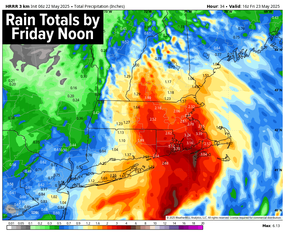
TABLE OF CONTENTS
* Daily Celestials (Sun/Moon)
* Sponsor Section
* Morning Discussion
~~~~~~~~~~~~~~~
YOUR DAILY CELESTIALS
~~~~~~~~~~~~~~~~~~~~~~
STAR:
–OUR STAR ROSE AT: 5:23am this morning
–OUR STAR SETS AT: 8:11pm this evening
–TOTAL DAYLIGHT TIME: 14 hours and 48 minutes
MOON:
–OUR MOON SETS AT: 2:45pm this afternoon
–MOON SET DIRECTION: West
–OUR MOON RISES AT: 3:00am tomorrow morning
–MOON RISE DIRECTION: East
–MOON PHASE: Waning Crescent (29.0%)
~~~~~~~~~~~~~~~~~~~~~~
A NOTE FROM OUR SPONSOR
~~~~~~~~~~~~~~~~~~~~~~
Dave Hayes The Weather Nut is Sponsored by Individual Community Members, Patrons, and Tandem Bagel Company… No matter the weather, Tandem Bagel is always there for you at several valley locations to make your mornings brighter! With *New Pizza Bagels(!)*, along with bagels baked fresh daily (including Gluten-Free options), house-whipped cream cheese, coffee, and tons of lunch options, Tandem is the perfect quick stop for lunch, breakfast, or a coffee and bagel to go.
You can either 1) visit them in Easthampton, Northampton, Hadley, Florence, and/or West Springfield, 2) hire them to cater your next event, or 3) use their super-streamlined online ordering tool by visiting their website and clicking the “Catering” or “Order Online” links.
~~~~~~~~~~~~~~~~~~~~~~
YOUR MORNING DISCUSSION
~~~~~~~~~~~~~~~~~~~~~~
Good morning folks, we’re starting off very cool this morning with temps in the mid to upper 30s in SVT and the 40s elsewhere. Rain is starting to track north-northeast into the greater WMass region, having already reached northern CT, the southern Berkshires and Hampden County in WMass.
This activity will fill in this morning and into the day, remaining lightest over Berkshire County (especially western areas) and Bennington County VT, and heaviest over northeast CT, far eastern areas of WMass nearest Worcester County, and Worcester County itself, possibly up into eastern parts of Cheshire County NH.
Today’s and tonight’s weather features a double-barrel low pressure system with a weakening primary low tracking NNE into the eastern Great Lakes and a deepening secondary low tracking NNE into the outer Cape, eventually destined for the Gulf of Maine as it hooks more straight northeast.
One thing to watch this morning in southern VT is that as precip pushes over the mountains, some snow may mix in before going over to plain rain for much of the day and early evening.
High temps will hang in the 40s all day long, and with easterly to northeasterly wind gusts of 20-35mph or so lasting into the night. In fact, some wind chills may dip into the mid to upper 30s, so a truly raw day lies ahead as our late-season nor’easter impacts the region.
Rain will continue tonight for many of us, though it should start to decrease for areas closer to the NY state line in CT, MA and VT, and will wind down for everybody else by early Friday morning with a few leftover showers.
However, in the high terrain of eastern Bennington County, western Windham County and far northeast Berkshire County into far western Hampshire and Franklin Counties in WMass, we could mix with or even flip to wet snow, and I can’t rule out a coating to an inch or so on grassy surfaces.
As for rain totals, I think that anywhere from about .75” to 2.5” of rainfall should fall, with lower range amounts towards the NY state line, and the higher amounts over CMass and northeast CT, with much of WMass seeing 1-1.75” or so.
Be sure to watch for street flooding in spots where heavy rain falls, especially east of the I-91 corridor in NH, MA and CT.
For Friday, our storm will pull away, but we’ll still have to deal with the upper low that will pass through our region Friday into the first part of Saturday, and that should foster some scattered showers at times, though no washout is expected.
Highs Friday and Saturday will still be unseasonably cool, only reaching the upper 40s to upper 50s from north to south and high terrain to low, with lows down into the 40s.
We’ll end Memorial Day Weekend with improving weather conditions. I expect a partly sunny and dry day for our Sunday with highs in the mid 50s to mid 60s, and a mostly sunny Memorial Day for Monday with highs in the mid 60s to low 70s, so that’s something to look forward to.
We’ll have a chance at more showers as we move into the middle of next week, but I do not expect temps to come down to such anomalously low levels as we’ll endure day into the first part of the weekend.
It’s not often you talk about snow in late May, much less a nor’easter with a pressure-chart look of Winter vs. Spring, but here we are, and we’re New Englanders for cripes sake, so we’ll move on through.
I hope something goes unexpectedly well for you today, and that you’re able to enjoy a nice meal, or work up a nice pot of nourishing soup to warm your bones today and tonight.
“Follow your bliss and the universe will open doors for you where there were only walls.”
― Joseph Campbell