
TODAY’S NUTSHELL: Cloudy skies and anomalously cooler temps will dominate our weather from today through Friday. Initially, we’ll have some drizzle patches form today with a few isolated showers, but by this evening a field of scattered showers will push from southwest to northeast into northwest CT and the Berkshires and expand east. By Thursday, a very late-season nor’easter pushes east through the Mid-Atlantic south of us, and into the Cape and Islands by later Thursday night bringing 1-2” of rain and east-northeast wind gusts of 20-40mph with many not seeing 50º tomorrow. Some isolated to scattered showers are possible later Friday into Saturday as we dry out and see temps rebound back up into Sunday and Monday with partly to mostly sunny skies developing to end our Memorial Day Weekend on the good foot.
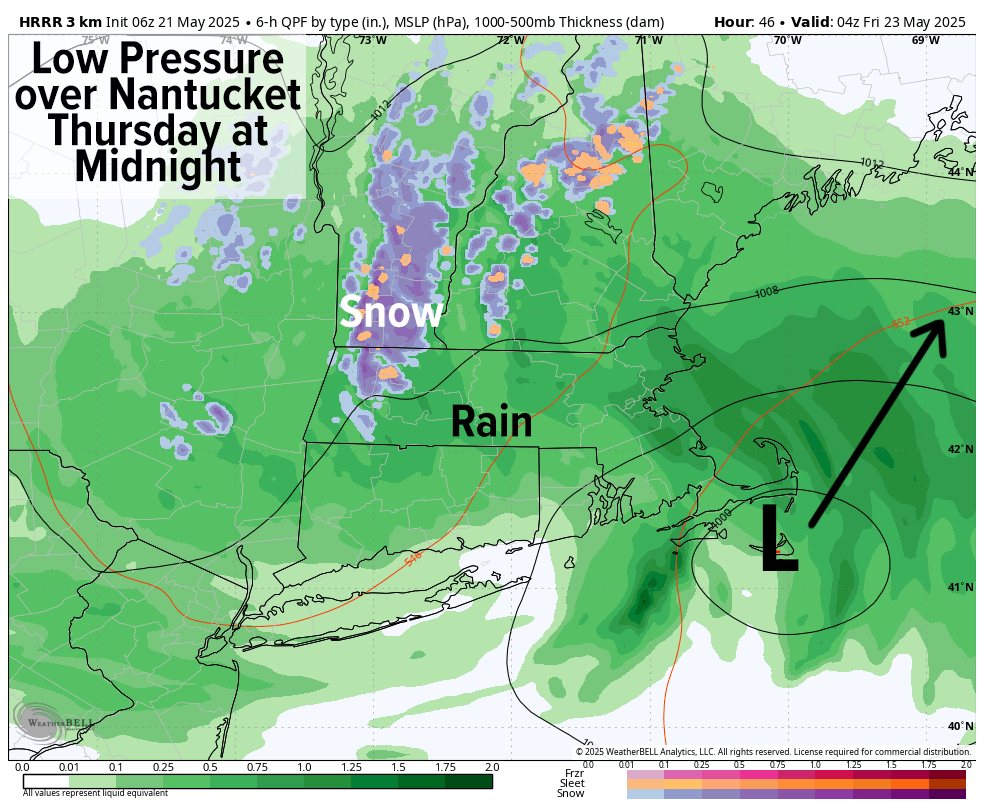
TABLE OF CONTENTS
* Daily Celestials (Sun/Moon)
* Sponsor Section
* Morning Discussion
~~~~~~~~~~~~~~~
YOUR DAILY CELESTIALS
~~~~~~~~~~~~~~~~~~~~~~
STAR:
–OUR STAR ROSE AT: 5:23am this morning
–OUR STAR SETS AT: 8:10pm this evening
–TOTAL DAYLIGHT TIME: 14 hours and 47 minutes
MOON:
–OUR MOON SETS AT: 1:41pm this afternoon
–MOON SET DIRECTION: West
–OUR MOON RISES AT: 2:38am tomorrow morning
–MOON RISE DIRECTION: East
–MOON PHASE: Waning Crescent (39.7%)
~~~~~~~~~~~~~~~~~~~~~~
A NOTE FROM OUR SPONSOR
~~~~~~~~~~~~~~~~~~~~~~
Dave Hayes The Weather Nut is Sponsored by Individual Community Members, Patrons, and Tandem Bagel Company… No matter the weather, Tandem Bagel is always there for you at several valley locations to make your mornings brighter! With *New Pizza Bagels(!)*, along with bagels baked fresh daily (including Gluten-Free options), house-whipped cream cheese, coffee, and tons of lunch options, Tandem is the perfect quick stop for lunch, breakfast, or a coffee and bagel to go.
You can either 1) visit them in Easthampton, Northampton, Hadley, Florence, and/or West Springfield, 2) hire them to cater your next event, or 3) use their super-streamlined online ordering tool by visiting their website and clicking the “Catering” or “Order Online” links.
~~~~~~~~~~~~~~~~~~~~~~
YOUR MORNING DISCUSSION
~~~~~~~~~~~~~~~~~~~~~~
Good morning folks, we have a pretty strong high pressure system positioned northeast of Maine that has set up a cold air damming situation helping to drain cooler air south-southwest into southern New England for today and tomorrow. Meanwhile, our low pressure system is gathering itself over the western Ohio Valley and is set to track east and off of the NJ coastline, destined to run over Cape Cod and the Islands late tomorrow night.
As our high pressure system departs slowly to the east, an onshore, east to northeast flow will develop and help to push some drizzle patches or a few showers from east to west today, most prominently in CMass, SWNH, and northeast CT.
Highs today will only reach the 50s under overcast skies, and by this evening into tonight, some easterly breezes will develop as the warm frontal showers extending ahead of our incoming low center (still well southwest of us) reaches northwest CT and the Berkshires.
Showers will start to fill in overnight as lows drop into the upper 30s to mid 40s, and I wouldn’t be surprised to see some wet snowflakes mix in over the southern Greens of SVT overnight.
By the time we wake up Thursday, more persistent and widespread rainfall and clusters of rain should be expanding into the greater WMass region as the morning wears on as our Nor’easter gets underway and produces a very rainy Thursday and Thursday night with generally 1-2” of rain expected by Friday morning.
In addition, as low pressure passes south of Long Island, the pressure gradient should increase, causing easterly to northeasterly wind gusts of 20-40mph to develop, peaking during the first part of Thursday night.
Highs on Thursday will only reach the mid 40s to low 50s, so it will be VERY raw and feel like very late Winter or early Spring.
SAY IT AIN’T SNOW!
Lastly, as the storm cranks up and we see the heaviest precip move in Thursday evening and night, dynamic cooling is looking probably over northwest MA and southern VT, and this could flip us to wet snow in the high terrain above 2000 feet with a wet coating to an inch or so of snow possible, with mixed rain and snow in lower terrain (yet elevated) areas of the northeast Berkshires, western Hampshire/Franklin Counties and SVT.
Lows Thursday night will bottom out into the mid 30s to low 40s.
Friday should see some showers in the morning, but the storm will lift northeast into the Gulf of Maine, so showers should decrease dramatically.
Still, some wraparound or instability showers are possible Friday with highs in the 50s, with lows in the 40s.
A few more showers are possible on Saturday, but some breaks of sunshine are expected with milder highs in the mid 50s to low 60s.
By Sunday into Monday we are improving much more with partly to mostly sunny skies and highs in the 60s Sunday and mid 60s to low 70s for Monday, with fair weather into early next week.
Have a great day!
“Follow your bliss and the universe will open doors for you where there were only walls.”
― Joseph Campbell