
TODAY’S NUTSHELL: Conditions will be slowly going downhill as clouds increase today, tonight and tomorrow due to increased onshore, easterly and northeasterly flow. This will produce some drizzle patches later tonight =and tomorrow with some scattered showers developing by afternoon and evening. It will be quite cool for this time of year, with Thursday and Thursday night featuring the coldest, rainiest and windiest conditions in the upcoming period. Friday looks cool, showery and gray, but slow improvement will develop from Saturday through Memorial Day Monday with some seeing 70º highs by then.
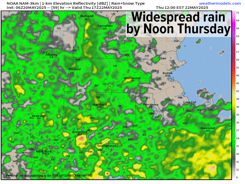
TABLE OF CONTENTS
* Daily Celestials (Sun/Moon)
* Sponsor Section
* Morning Discussion
~~~~~~~~~~~~~~~
YOUR DAILY CELESTIALS
~~~~~~~~~~~~~~~~~~~~~~
STAR:
–OUR STAR ROSE AT: 5:24am this morning
–OUR STAR SETS AT: 8:09pm this evening
–TOTAL DAYLIGHT TIME: 14 hours and 45 minutes
MOON:
–OUR MOON SETS AT: 12:28pm this morning
–MOON SET DIRECTION: West-Southwest
–OUR MOON RISES AT: 2:15am tomorrow morning
–MOON RISE DIRECTION: East-Southeast
–MOON PHASE: Waning Crescent (50.6%)
~~~~~~~~~~~~~~~~~~~~~~
A NOTE FROM OUR SPONSOR
~~~~~~~~~~~~~~~~~~~~~~
Dave Hayes The Weather Nut is Sponsored by Individual Community Members, Patrons, and Tandem Bagel Company… No matter the weather, Tandem Bagel is always there for you at several valley locations to make your mornings brighter! With *New Pizza Bagels(!)*, along with bagels baked fresh daily (including Gluten-Free options), house-whipped cream cheese, coffee, and tons of lunch options, Tandem is the perfect quick stop for lunch, breakfast, or a coffee and bagel to go.
You can either 1) visit them in Easthampton, Northampton, Hadley, Florence, and/or West Springfield, 2) hire them to cater your next event, or 3) use their super-streamlined online ordering tool by visiting their website and clicking the “Catering” or “Order Online” links.
~~~~~~~~~~~~~~~~~~~~~~
YOUR MORNING DISCUSSION
~~~~~~~~~~~~~~~~~~~~~~
Good morning everybody, we continue to be influenced by a stalled upper low trough in Atlantic Canada, while an upper ridge (i.e. area of higher pressures aloft) works east into western New England today, providing an easing of our gusty winds from yesterday and overnight.
In addition, it will help to develop some partly sunny skies early before we cloud up later today.
Highs will reach the mid to upper 50s, and clouds will thicken tonight with lows in the mid to upper 40s with patchy drizzle possible, especially east of the I-91 corridor.
On Wednesday we’ll be watching two processes take place. The first involves showers pushing in from the southwest later in the day and especially at night as our low pressure center starts to take shape down over the Mid-Atlantic region. The second process will be the initiation of onshore, easterly flow from off of the ocean, which will continue the development of patchy drizzle and even some scattered light showers, especially in CMass and northeast CT.
Highs will hover somewhere around the mid 50s under mostly cloudy skies, which is more than 10 degrees below average for late May.
By Wednesday night, showers will continue to develop and an east breeze should kick up with gusts to 20mph at times. Lows will drop into the 40s.
Thursday is our storm day, with a very late-season nor’easter developing to our south off of New Jersey, which will track east-northeast south of the coast through the day, spreading rainfall throughout the greater WMass region, with steadier rains to the south and east, and a bit less rain up in SVT/SWNH.
But don’t get me wrong, this looks like a widespread, fairly well developed rainstorm, with highs Thursday only in the mid 40s to low 50s!
In addition, east to northeast winds will gust 25-40mph at times, and rain will continue into Thursday night with lows in the upper 30s to low 40s and continued gusty conditions. I still can’t rule out some wet snow in the high peaks of the southern Green Mountains in VT.
As our storm tracks further east-northeast towards Martha’s Vineyard Thursday night into Friday morning (depending on the position of the stalled/slowed older upper low in Atlantic Canada), it may be forced to take a left hook and track right over the Cape Cod Canal, rather than proceeding over Nantucket.
Regardless, Thursday night into Friday morning looks rainy and gusty as well, but the storm should continue to track into the Gulf of Maine and away on Friday, leading to some more scattered showers for later on Friday vs. the widespread rain of Thursday. Highs Friday will be in the 50s with lows in the 40s.
Rainfall totals should climb to between 1-2”, though some areas will see less than an inch, especially the further north and west you go.
Our second upper low that spawns our Thursday nor’easter moves through the region Friday and Saturday, and of course as we know, that produces some unsettled conditions in scattered showers which I expect for Friday night into Saturday.
This brings us to the Memorial Day Weekend forecast, and the good news is that temps will be increasing Saturday through Monday. Highs will reach the mid 50s to low 60sw on Saturday, then well into the 60s Sunday, and some of us will even hit 70º on Memorial Monday, so that’s good news.
In addition, despite some scattered showers on Saturday, we should see more of a partly sunny Sunday and a fully sunny Monday, so Wednesday night into Thursday represents a meteorological setback, by Memorial Day we’re back in line with more springtime conditions.
Have a great day!
“Follow your bliss and the universe will open doors for you where there were only walls.”
― Joseph Campbell