
TODAY’S NUTSHELL: Good morning folks, what turned out to be a horrible night of non-sleep for me featuring all the spooky ghosts of my past in one set of dreams (woo hoo, let’s party!!) was made even more exciting by the boomers that ripped through our region between about 3-5am, waking many of us up. Some isolated showers/storms today and tonight gives way to fairly low but present severe thunderstorm chance Saturday afternoon as warmth peaks today and tomorrow. This will be followed by periods of showers Sunday through Wednesday with some dry spells in between to be better determined as we get closer to each of those days.
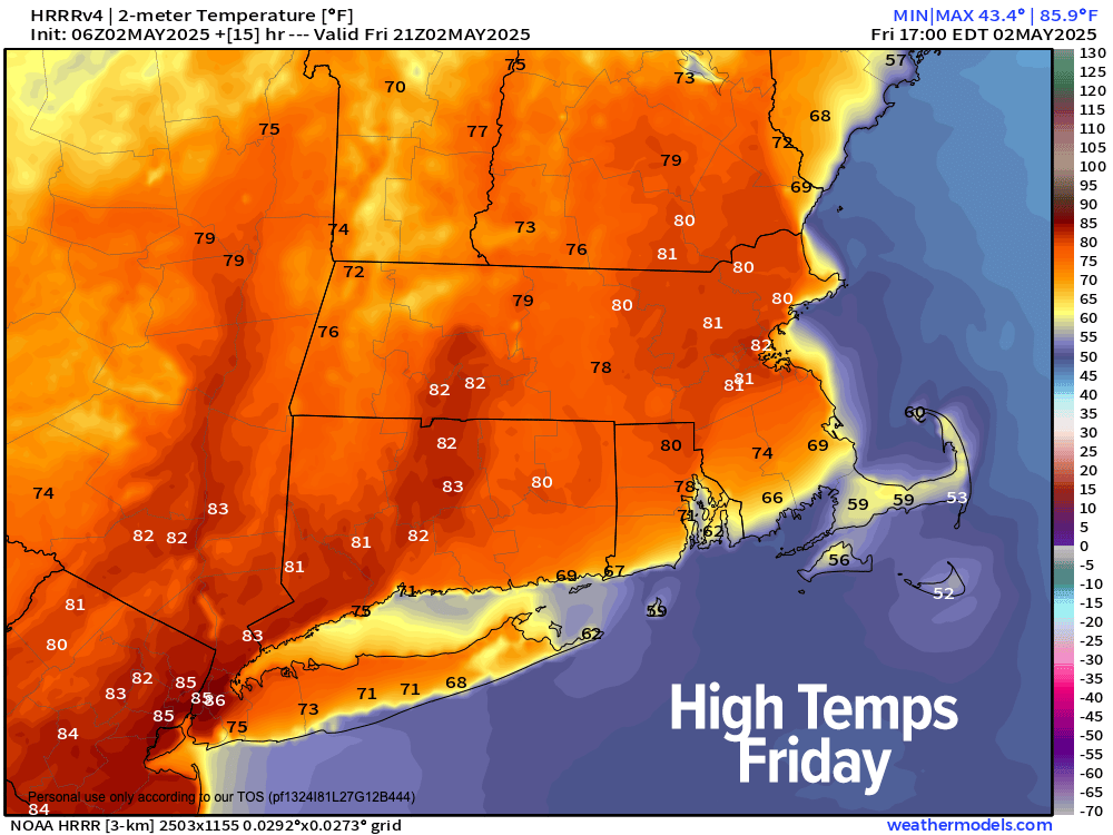
TABLE OF CONTENTS
* Daily Celestials (Sun/Moon)
* Sponsor Section
* Your Short-Term ZoneCast
* Morning Discussion
~~~~~~~~~~~~~~~
YOUR DAILY CELESTIALS
~~~~~~~~~~~~~~~~~~~~~~
STAR:
–OUR STAR ROSE AT: 5:44am this morning
–OUR STAR SETS AT: 7:50pm this evening
–TOTAL DAYLIGHT TIME: 14 hours and 6 minutes
MOON:
–OUR MOON RISES AT: 9:38am this morning
–MOON RISE DIRECTION: Northeast
–OUR MOON SETS AT: 1:43am tomorrow morning
–MOON SET DIRECTION: Northwest
–MOON PHASE: Waxing Crescent (28.2%)
~~~~~~~~~~~~~~~~~~~~~~
A NOTE FROM OUR SPONSOR
~~~~~~~~~~~~~~~~~~~~~~
Dave Hayes The Weather Nut is Sponsored by Individual Community Members, Patrons, and Tandem Bagel Company… No matter the weather, Tandem Bagel is always there for you at several valley locations to make your mornings brighter! With *New Pizza Bagels(!)*, along with bagels baked fresh daily (including Gluten-Free options), house-whipped cream cheese, coffee, and tons of lunch options, Tandem is the perfect quick stop for lunch, breakfast, or a coffee and bagel to go.
You can either 1) visit them in Easthampton, Northampton, Hadley, Florence, and/or West Springfield, 2) hire them to cater your next event, or 3) use their super-streamlined online ordering tool by visiting their website and clicking the “Catering” or “Order Online” links.
~~~~~~~~~~~~~~~~~~~~~~
YOUR SHORT-TERM ZONECAST
~~~~~~~~~~~~~~~~~~~~~~
ZONE 1 – Northern Region
(Southern VT, Southwest NH)
–Highs Today: Mid to Upper 70s
–Lows Tonight: Mid 50s
–Highs Tomorrow: Upper 60s to Mid 70s
–Winds: Light southerly today and tonight to light westerly tomorrow, except in any strong/severe t-storms that may form
–Skies: Mostly cloudy through tomorrow
–Precip: Isolated showers or a thunderstorm today, tonight, with more numerous showers and a couple of strong to severe t-storms later Saturday afternoon
–NWS Alerts + Nut Notes: Any severe storms on Saturday could produce isolated damaging wind gusts… patchy fog in posts this and tomorrow morning as well
ZONE 2 – Central Region
(Western MA, North-Central MA, Northern Litchfield CT)
–Highs Today: 70s to low 80s
–Lows Tonight: Mid to Upper 50s
–Highs Tomorrow: 70s to low 80s
–Winds: Light southerly today and tonight to light westerly tomorrow, except in any strong/severe t-storms that may form
–Skies: Mostly cloudy through tomorrow
–Precip: Isolated showers or a thunderstorm today, tonight, with more numerous showers and a couple of strong to severe t-storms later Saturday afternoon
–NWS Alerts + Nut Notes: Any severe storms on Saturday could produce isolated damaging wind gusts… patchy fog in posts this and tomorrow morning as well
ZONE 3 – Southern Region
(South-Central MA, Northern CT)
–Highs Today: Upper 70s to low 80s
–Lows Tonight: Mid to Upper 50s
–Highs Tomorrow: Low 80s
–Winds: Light southerly today and tonight to light westerly tomorrow, except in any strong/severe t-storms that may form
–Skies: Mostly cloudy through tomorrow
–Precip: Isolated showers or a thunderstorm today, tonight, with more numerous showers and a couple of strong to severe t-storms later Saturday afternoon
–NWS Alerts + Nut Notes: Any severe storms on Saturday could produce isolated damaging wind gusts… patchy fog in posts this and tomorrow morning as well
~~~~~~~~~~~~~~~~~~~~~~
YOUR MORNING DISCUSSION
~~~~~~~~~~~~~~~~~~~~~~
Good morning folks, those pre-dawn thunderstorms certainly cranked a few clocks overnight, whoa!! There was no real wind or hail that I’ve heard about, but certainly LOUD booms, heavy rain, and no doubt some panting pooches jumping up on beds, poor things. No fun for the canines!
That cluster of storms has tracked northeast and away, and now we’re left with some patchy fog in spots (patchy fog will also be around tomorrow morning) and we’re set to see temps run up into the 70s to low 80s behind our warm front.
Yesterday was the last nice day we’ll see for a while. It’s not that it won’t be warm or mild, certainly our temperatures will be easy to take.
The problem lies in a lollygagging, aimless, confused cutoff upper low that will be slowly whirling around the Ohio Valley for the next several days before it gets re-attached to the steering flow by mid-week and carried through New England and out to sea by late next week.
Now that our warm front has passed us by, we’re in a more humid, soupy air mass and will be under the influence said upper low for days to come, which means periods of showers and thunderstorms at times each day, from today through Wednesday.
Does everyone get wet in the greater WMass region over the next 6 days?
NAY.
However, somebody will, and for today with highs in the 70s to low 80s, we’ll see occasional isolated showers and perhaps a thunderstorm or two later today or this evening. Lows tonight will dip into the mid 50s or so, with a shower or storm possible.
For Saturday, we should start of on the drier side with some patchy fog in the morning, and temps will be set to run up into the 70s to low 80s once again.
A batch of showers may move through around mid-day, but the better chance for showers and even a couple strong to even severe thunderstorms will be later in the afternoon toward the 4-8pm timeframe when humidity may burst with dewpoints reaching the mid 60s.
The concern would be for strong to perhaps isolated damaging wind gusts in the later afternoon or early evening. Lows will dip only to the mid to upper 50s with periods of rain moving through.
By Sunday, a frontal boundary looks to get hung up somewhere over our region, and that likely will focus additional periods of showers as high temps cool into the upper 50s to mid 60s, and lows in the 40s.
That general temperature profile for Sunday should copy/paste through at least Tuesday, and perhaps even Wednesday as we remain under the influence of a sitting, spinning, and stalled out upper low.
This lazy upper level system will keep feeding waves of moisture and showers our way through mid-week until it tracks through New England and out to sea by Thursday.
I will do my best to cipher the details for you and present them as each day comes and goes, and I thank you for your readership, and I hope you have better dreams tonight than I did last night, because that crap was for the birds!
Have a great day!
“Follow your bliss and the universe will open doors for you where there were only walls.”
― Joseph Campbell