
TODAY’S NUTSHELL: The upper low that spawned severe weather for some on Saturday along with some super creepy skies is now east of Maine, but isn’t moving very much, and as such will spawn northwest wind gusts of 20-35mph for today and tonight, slackening on Tuesday. The trend will be for temps to cool through the week, with highs only reaching the 50s for Wednesday through Friday. In addition by Wednesday night through Friday morning we are likely to see at least some periods of light to moderate rain if not a full-on rainy nor’easter with gusty winds, centered on Thursday, with a low chance for wet snow in far northwest MA and SVT Thursday night before temps start to tick back up into the weekend.
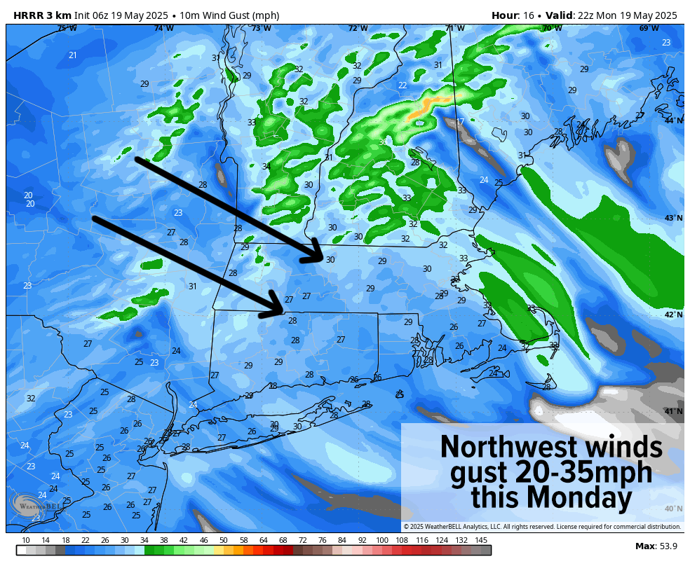
TABLE OF CONTENTS
* Daily Celestials (Sun/Moon)
* Sponsor Section
* Morning Discussion
~~~~~~~~~~~~~~~
YOUR DAILY CELESTIALS
~~~~~~~~~~~~~~~~~~~~~~
STAR:
–OUR STAR ROSE AT: 5:25am this morning
–OUR STAR SETS AT: 8:08pm this evening
–TOTAL DAYLIGHT TIME: 14 hours and 43 minutes
MOON:
–OUR MOON SETS AT: 11:16am this morning
–MOON SET DIRECTION: West-Southwest
–OUR MOON RISES AT: 1:52am tomorrow morning
–MOON RISE DIRECTION: East-Southeast
–MOON PHASE: Waning Gibbous (61.2%)
~~~~~~~~~~~~~~~~~~~~~~
A NOTE FROM OUR SPONSOR
~~~~~~~~~~~~~~~~~~~~~~
Dave Hayes The Weather Nut is Sponsored by Individual Community Members, Patrons, and Tandem Bagel Company… No matter the weather, Tandem Bagel is always there for you at several valley locations to make your mornings brighter! With *New Pizza Bagels(!)*, along with bagels baked fresh daily (including Gluten-Free options), house-whipped cream cheese, coffee, and tons of lunch options, Tandem is the perfect quick stop for lunch, breakfast, or a coffee and bagel to go.
You can either 1) visit them in Easthampton, Northampton, Hadley, Florence, and/or West Springfield, 2) hire them to cater your next event, or 3) use their super-streamlined online ordering tool by visiting their website and clicking the “Catering” or “Order Online” links.
~~~~~~~~~~~~~~~~~~~~~~
YOUR MORNING DISCUSSION
~~~~~~~~~~~~~~~~~~~~~~
Good morning everybody, we are going to continue to be under the influence of a pair of upper lows this week, one that’s on the way out, and another that’s on the way in.
For today into early Wednesday, we’ll remain under the influence of the first upper low that’s wandering about Atlantic Canada to the east of Maine, similar to the way I wandered about for the first two adult decades of my life: rather clueless, mostly drunk, and slowly moving around in circles getting nowhere.
It happens. And like my earlier adult life, so to will our upper low pick itself up by its bootstraps, stand up, and move along with some more vigor.
But for now, our lazy Dave low will meteorologically pontificate all over us today with northwest wind gusts of 20-35mph, lasting through tonight.
Highs (under partly sunny to mostly cloudy skies) will only reach the upper 50s to mid 60s from north to south in the greater WMass region, with gusts continuing tonight as lows dip into the upper 30s to mid 40s.
For Tuesday, partly sunny skies are expected as the first upper low pulls east a bit more into Nova Scotia with highs in the low 60s along with less wind, and lows in the low to mid 40s.
High pressure tries to build in on Wednesday to our northwest, but our second upper low will be pushing in from the southwest and help to spawn a coastal surface low pressure center by Thursday that will track somewhere south of New England, though it’s uncertain how close to the coast it’ll come.
Highs Wednesday will only reach the mid to upper 50s as northeast flow starts to get established, and a few showers will be possible by afternoon or especially the evening with lows in the 40s.
Thursday into Thursday night looks like our stormiest period this week, and coolest as well!
Our storm should track south of the coast, and push periods of rain and at least some breezy conditions if not gusty conditions for Thursday and Thursday night with highs only in the upper 40s to low 50s — a *very* raw day for late May standards!
In addition, lows will be dropping into the mid 30s to low 40s Thursday night and if the low center tracks close enough to WMass, the dynamic cooling that could result with heavier precipitation loads could help flip the northwest hilltowns northeast Berkshires and the southern Greens in VT to wet snow, or a rain/snow mix.
Friday through Sunday should feature a slow recover of temps, climbing back up well into the 50s, and then 60s by the end of the weekend.
This period is still murky to me and could actually feature a second surface low center forming with more showers during this period, but I will need more time to parse this out for you all.
I will keep you all updated, and I hope you have a great day!
“Follow your bliss and the universe will open doors for you where there were only walls.”
― Joseph Campbell