
TODAY’S NUTSHELL: An anomalously strong upper low is tracking east toward New England this weekend which will send a cold front through our region tonight, acting on our Soupy Sales air mass in place. While a few showers are possible this morning, the best chance for strong to severe thunderstorms with isolated damaging wind gusts will be by midi to late afternoon into early evening. Torrential rain and small hail will also be possible. Sunday is a breezier, partly sunny and cooler day with a few spot showers around, as we transition into a pair of sunny 60s days for Monday and Tuesday prior to a rainy (and perhaps windy) late-season Nor’easter Wednesday night into Thursday with very cool temps for late May!
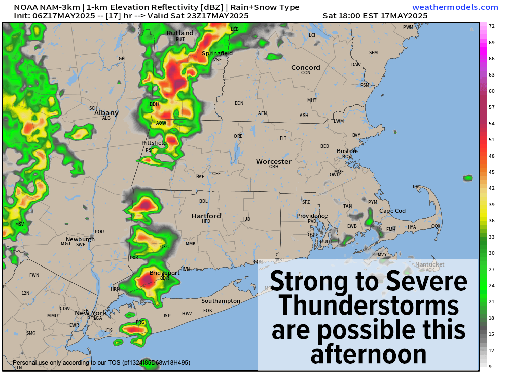
TABLE OF CONTENTS
* Daily Celestials (Sun/Moon Data)
* Sponsor Section
* Morning Discussion
~~~~~~~~~~~~~~~~~~~~~~
YOUR DAILY CELESTIALS
~~~~~~~~~~~~~~~~~~~~~~
STAR:
–OUR STAR ROSE AT: 5:27am this morning
–OUR STAR SETS AT: 8:06pm this evening
–TOTAL DAYLIGHT TIME: 14 hours and 39 minutes
MOON:
–OUR MOON SETS AT: 8:56am this morning
–MOON SET DIRECTION: Southwest
–OUR MOON RISES AT: 12:54am tomorrow morning
–MOON RISE DIRECTION: Southeast
–MOON PHASE: Waning Gibbous (79.4%)
~~~~~~~~~~~~~~~~~~~~~~
>>> A NOTE FROM OUR WEEKEND SPONSOR <<<
Dave Hayes The Weather Nut is Sponsored by Individual Community Members, Patrons, and Gerard, Ghazey & Bates, P.C.
GGBPC is a Northampton-based law firm and is the area’s premier estate and tax planning provider. The firm specializes in Estate Planning, Elder Law, and Tax Law, so be sure to contact GGBPC today to see how they can help you.
Simply click the following link to their secure website.
~~~~~~~~~~~~~~~~~~~~~~
YOUR MORNING DISCUSSION
~~~~~~~~~~~~~~~~~~~~~~
Good morning folks, we’re starting off socked in with low-level stratus clouds with a few showers around in SVT, and patchy drizzle with patchy fog, dense in some spots.
By mid to late morning, we should see fog let up, though drizzle in spots may linger. Despite a few showers this morning, we should see some breaks in the cloud deck in the WMass region and that should help combine with pre-existing elevated humidity to warm temps up to the 75-80º range which will destabilize the atmosphere.
As this happens, an upper low tracking east will push a cold front toward New England, and should help to pop clusters of showers, downpours, and a few strong to perhaps severe thunderstorms by mid to late afternoon, into early evening.
I also cannot rule out a weaker tornado forming there will be some low level spin in the lower atmosphere with our arcing cold frontal passage.
Isolated wind damage is possible, along torrential rain, frequent lightning, street flooding and smaller hail.
I will be updating again by mid-day as to our severe storm potential.
For tonight, our activity dissipates as our cold front moves through, dropping lows into the upper 40s to mid 50s with northwest breezes picking up as drier and cooler air advects into our region.
For Sunday, a few spots showers are possible, along with a mixed cloud sun day with cooler highs only in the upper 50s to mid 60s with northwest winds gusting to 20-30mph and lows in the 40s.
Monday and Tuesday look breezy, sunnier, and cool with highs in the mid 50s to mid 60s with lows in the 40s as high pressure moves into the region.
By Wednesday, however, we’ll start off partly sunny but trend to mostly cloudy skies with highs only in the 50s as yet another (and this time, highly-anomalous) upper low system tracks toward the eastern Great Lakes and spawns a coastal low off of the Mid-Atlantic coastline by Wednesday night.
Where this low tracks will have implications for our sensible weather Wednesday night into Thursday night, which could include widespread rainfall with windy conditions as the potential for a late-season nor’easter is on our weather table!
Some showers may continue into Friday and high temps look to remain in the 50s for the late-week period, so the cold season doesn’t want to fully release us into Summah yet!
Have a great day and I will update again later!
“Follow your bliss and the Universe will open doors for you where there were only walls.”
― Joseph Campbell