
TODAY’S NUTSHELL: Strong high pressure will begin to dive southeast toward New England out of southeast Ontario, providing us with sunshine and dry conditions through Tuesday. By mid-week, some light to moderate showers are possible as a weakening trough pushes toward us. Warmer temps are expected Friday into the weekend.
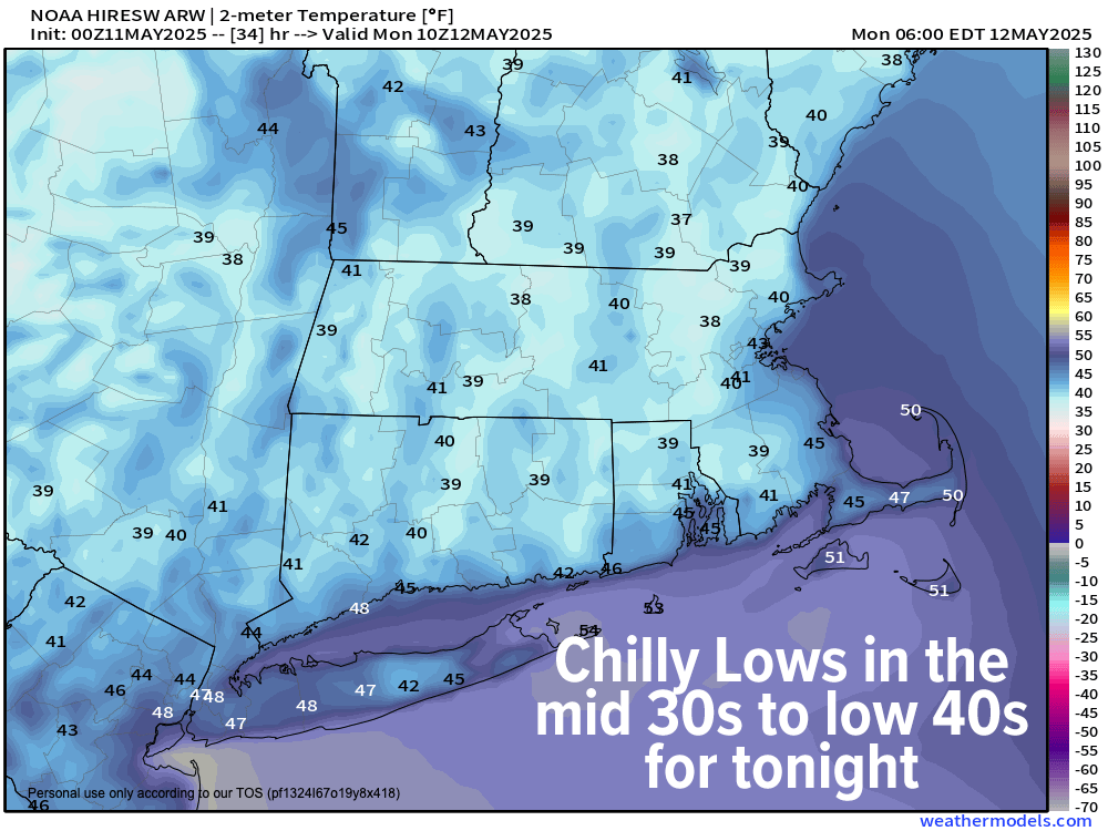
TABLE OF CONTENTS
* Daily Celestials (Sun/Moon Data)
* Sponsor Section
* Morning Discussion
~~~~~~~~~~~~~~~~~~~~~~
YOUR DAILY CELESTIALS
~~~~~~~~~~~~~~~~~~~~~~
STAR:
–OUR STAR ROSE AT: 5:33am this morning
–OUR STAR SETS AT: 8:00pm this evening
–TOTAL DAYLIGHT TIME: 14 hours and 27 minutes
MOON:
–OUR MOON RISES AT: 7:24pm this afternoon
–MOON RISE DIRECTION: East-Southeast
–OUR MOON SETS AT: 5:05am tomorrow morning
–MOON SET DIRECTION: West-Southwest
–MOON PHASE: Waxing Gibbous (98.5%)
~~~~~~~~~~~~~~~~~~~~~~
>>> A NOTE FROM OUR WEEKEND SPONSOR <<<
Dave Hayes The Weather Nut is Sponsored by Individual Community Members, Patrons, and Gerard, Ghazey & Bates, P.C.
GGBPC is a Northampton-based law firm and is the area’s premier estate and tax planning provider. The firm specializes in Estate Planning, Elder Law, and Tax Law, so be sure to contact GGBPC today to see how they can help you.
Simply click the following link to their secure website.
~~~~~~~~~~~~~~~~~~~~~~
YOUR MORNING DISCUSSION
~~~~~~~~~~~~~~~~~~~~~~
Good morning folks, given our incoming fair weather I’m going to take tomorrow morning off from reporting, but will update you again by tomorrow afternoon and again Tuesday morning, as our weather is quite light over the next few days.
Today will be mostly sunny, with some breezy gusts to 20mph or so, and highs in the 60s to perhaps 70º in the southern valley.
High pressure approaches from our northwest tonight and wind will go light, and skies will be clear, and air will be dry.
This will allow for maximum radiational cooling and as such, lows will plummet into the mid 30s to low 40s. I can’t rule out a patch or two of frost, either, but it would be the exception if it occurred.
Monday looks sunny and lovely with highs in the low to mid 70s with lows in the low 50s under partly cloudy skies.
Tuesday looks to be a more partly sunny day with high thin clouds approaching from the southwest as a weak trough tries to push some showers our way by mid-week. Highs will reach the low to mid 70s with lows in the 50s as clouds increase.
By Wednesday into Thursday, periods of scattered showers are expected as a weak trough slowly pushes up against departing high pressure, but a wash out is not expected.
What I do expect is warming temps later in the week, with highs in the 70s on Thursday, and then the mid 70s to low 80s Friday and Saturday.
Deeper Spring is landing with our first 8pm sunset tonight, and the Full Flower Moon arriving tomorrow night.
Have a great day!
“Follow your bliss and the Universe will open doors for you where there were only walls.”
― Joseph Campbell