
–> 100s of storms over 12 years
–> 1000s of daily reports & updates
–> Keep Dave on the job through all storms
–> 65% towards the 4% reader goal, Drive ends 3/16
–> ^^ SecureClick to support Dave’s work ^^
~~~~~~~~~~~~~~~
TABLE OF CONTENTS
* Daily Celestials (Sun/Moon Data)
* Sponsor Note
* Morning Discussion
* TIP: Scroll below for sections, or read all
~~~~~~~~~~~~~~~
YOUR DAILY CELESTIALS
~~~~~~~~~~~~~~~~~~~~~~
STAR:
–OUR STAR ROSE AT: 6:15am this morning
–OUR STAR SETS AT: 5:47pm this evening
–TOTAL DAYLIGHT TIME: 11 hours and 32 minutes
MOON:
–OUR MOON RISES AT: 10:48am this morning
–MOON RISE DIRECTION: Northeast
–OUR MOON SETS AT: 3:21am tomorrow morning
–MOON SET DIRECTION: Northwest
–MOON PHASE: Waxing Gibbous (59.0%)
~~~~~~~~~~~~~~~~~~~~~~
A NOTE FROM OUR SPONSOR
~~~~~~~~~~~~~~~~~~~~~~
Dave Hayes The Weather Nut is Sponsored by Individual Community Members, Patrons, and Tandem Bagel Company… No matter the weather, Tandem Bagel is always there for you at several valley locations to make your mornings brighter! With *New Pizza Bagels(!)*, along with bagels baked fresh daily (including Gluten-Free options), house-whipped cream cheese, coffee, and tons of lunch options, Tandem is the perfect quick stop for lunch, breakfast, or a coffee and bagel to go.
You can either 1) visit them in Easthampton, Northampton, Hadley, Florence, and/or West Springfield, 2) hire them to cater your next event, or 3) use their super-streamlined online ordering tool by visiting their website and clicking the “Catering” or “Order Online” links.
~~~~~~~~~~~~~~~~~~~~~~
YOUR MORNING DISCUSSION
~~~~~~~~~~~~~~~~~~~~~~
Good morning everybody, lord know when the cold wind blows it’ll sit you straight up in bed and scare the crap out of you!
That was fun last night… NOT.
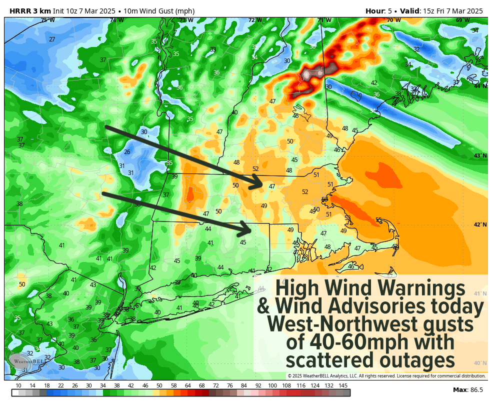
It was during that pre-dawn timeframe between about 2am to 4am that the winds really maxed out and cranked up, producing a 61mph gust in Pittsfield, MA, and numerous 50+ gusts with no doubt some 60+ gusts in other spots.
The outages are there to prove it, too, with almost 10,000 outages in northern CT and about 2500 in WMass and CMass combined, with Hampden County hardest hit at the moment. SVT and SWNH have about 500 outages for now.
Unfortunately, folks, this number is going UP as the sun rises in the sky, and mixes the surface atmosphere with the wind located about a mile up as deep low pressure pulls away into Atlantic Canada, and vacuums air across New England and into its center as it does so.
Our wind gusts are expected to roar today well into the afternoon, and reach speeds of 40-65mph at times, so please be aware of any flying debris from twigs or branches (also watch for black ice early this morning).
Highs today will reach the 30s today under partly to mostly sunny skies, with a few 40º readings in the southern valley. Wind chills will be in the upper teens to 20s, so bundle up!
We’ll also see some scattered lake effect snow showers develop, so don’t be surprised if the snow flies.
For tonight, the wind will die down a bit, but it’ll still be breezy overnight with gusts up to 35mph or so at times with lows in the mid to upper 20s and wind chills down into the teens.
For Saturday, wind will pick back up as a pressure gradient will still be present over the region, and gusts of 25-45mph are expected, with some areas pinning 50mph. High will sit in the 30s once again under mostly sunny skies with lows in the low to mid 20s.
By Sunday, we’ll have our pick of the weekend in play with highs in the upper 30s to mid 40s under mostly sunny skies with less wind, yahoo!! Lows drop into the upper 20s.
Then we’ll see Episode 3 of The Mildening kick into gear as high pressure tracks south of us, pushing real warmth into southern New England by mid week.
Fair weather is expected throughout with highs in the mid 40s to low 50s Monday, the 50s on Tuesday, and then the mid 50s to low 60s. We may see a few showers by Thursday, but I don’t see any real precipitation until we get to early the following week, so a dry period is on tap!
Have a great day and I hope we can stick together in 2025, as my annual support drive ends a week from Sunday and still about two-thirds to reaching my annual 4% reader support goal (secure click to support Dave’s work through 2025).
“Follow your bliss and the universe will open doors for you where there were only walls.”
― Joseph Campbell