
TABLE OF CONTENTS
* Daily Celestials (Sun/Moon Data)
* Sponsor Section
* Morning Discussion
* TIP: Scroll to your section, or read more
~~~~~~~~~~~~~~~~~~~~~~
YOUR DAILY CELESTIALS
~~~~~~~~~~~~~~~~~~~~~~
STAR:
–OUR STAR ROSE AT: 6:49am this morning
–OUR STAR SETS AT: 7:05pm this evening
–TOTAL DAYLIGHT TIME: 12 hours and 16 minutes
MOON:
–OUR MOON SETS AT: 11:07am this morning
–MOON SET DIRECTION: Southwest
–OUR MOON RISES AT: 3:38am tomorrow morning
–MOON RISE DIRECTION: Southeast
–MOON PHASE: Waning Crescent (49.9%)
~~~~~~~~~~~~~~~~~~~~~~
>>> A NOTE FROM OUR WEEKEND SPONSOR <<<
Dave Hayes The Weather Nut is Sponsored by Individual Community Members, Patrons, and Gerard, Ghazey & Bates, P.C.
GGBPC is a Northampton-based law firm and is the area’s premier estate and tax planning provider. The firm specializes in Estate Planning, Elder Law, and Tax Law, so be sure to contact GGBPC today to see how they can help you.
Simply click the following link to their secure website — https://www.ggbpc.com/
~~~~~~~~~~~~~~~~~~~~~~
YOUR MORNING DISCUSSION
~~~~~~~~~~~~~~~~~~~~~~
Good morning folks, we’ve got a few inclement periods coming up through next Friday, but these likely all fall into my #NoBigWhoop category of impacts.
However, Monday morning’s commute stands out a bit in terms of its potential to produce a coating to 2” of wet snow which likely will time well with the morning commute, so just something to keep in the back of your mind for now.
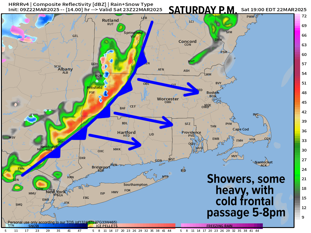
For today, expect southwest gusts of 20-30mph or so ahead of an incoming cold front this evening, which sweeps through between about 5-8pm.
Mostly sunny skies into the mid-afternoon with highs in the upper 40s to mid/upper 50s will bow and relent to incoming cloudiness, with some showers moving through late afternoon and early evening.
This activity is likely scattered and lighter, but whenever guidance pops a squall-line look, well, don’t be surprised if a shower or two are heavier and gusty/squally.
Behind this evening’s front, another wind bag releases its big inhale and empties its colder belly-full of bluster through the greater WMass region overnight, which looks a bit noisy. Northwest wind gusts of 30-45mph are expected, and I can’t rule out a few isolated outages in the high terrain as lows plummet into the upper teens and 20s with drying conditions.
For Sunday, it will be colder, with northwest gusts early slackening by afternoon under mostly sunny skies with highs only in the 30s to low 40s.
Clouds will increase at night as lows drop down into the 20s (with lows 20s in SVT) which sets up a cold surface environment for warm frontal precipitation to run into, glide over, and produce light to moderate snow, arriving from west to east between about 2am-5am (Berkshires to Wistah).
This is a *warm* front pushing in, so we should all turn to rain by mid to later Monday morning (earlier along and south of the Pike, later north), but with a cold surface overnight and a pretty cold Sunday, I think we could see a coating to 2” of wet late-March snow, which may cause some slippery travel either side of dawn Monday morning.
Eventually we all flip to rain as highs rise up and into the mid 30s to mid 40s, with precip quitting by afternoon sometime. Lows will dip into the 20s.
On Tuesday, a partly sunny day arrives with brief high pressure, and highs reaching the upper 30s to upper 40s with lows in the mid to upper 20s. We’re not exactly rocketing into warmer weather just yet, though that will come.
By Wednesday, another system passes south and may bring some mixed rain and snow showers, with best chance of precipitation south of the Pike and highs in the upper 30s to upper 40s with lows near freezing.
The late week period should feature zonal flow with highs in the 40s to low 50s by Friday, so we’ll end the week on a dry note, most likely.
Have a great day!
“Follow your bliss and the universe will open doors for you where there were only walls.”
― Joseph Campbell