
TABLE OF CONTENTS
* Daily Celestials (Sun/Moon Data)
* Sponsor Note
* Morning Discussion
* TIP: Scroll below for sections, or read all
~~~~~~~~~~~~~~~
YOUR DAILY CELESTIALS
~~~~~~~~~~~~~~~~~~~~~~
STAR:
–OUR STAR ROSE AT: 6:56am this morning
–OUR STAR SETS AT: 7:00pm this evening
–TOTAL DAYLIGHT TIME: 12 hours and 4 minutes
MOON:
–OUR MOON SETS AT: 8:30am this morning
–MOON SET DIRECTION: West-Southwest
–OUR MOON RISES AT: 11:43pm tonight
–MOON RISE DIRECTION: East-Southeast
–MOON PHASE: Waning Gibbous (85.1%)
~~~~~~~~~~~~~~~~~~~~~~
A NOTE FROM OUR SPONSOR
~~~~~~~~~~~~~~~~~~~~~~
Dave Hayes The Weather Nut is Sponsored by Individual Community Members, Patrons, and Tandem Bagel Company… No matter the weather, Tandem Bagel is always there for you at several valley locations to make your mornings brighter! With *New Pizza Bagels(!)*, along with bagels baked fresh daily (including Gluten-Free options), house-whipped cream cheese, coffee, and tons of lunch options, Tandem is the perfect quick stop for lunch, breakfast, or a coffee and bagel to go.
You can either 1) visit them in Easthampton, Northampton, Hadley, Florence, and/or West Springfield, 2) hire them to cater your next event, or 3) use their super-streamlined online ordering tool by visiting their website and clicking the “Catering” or “Order Online” links.
~~~~~~~~~~~~~~~~~~~~~~
YOUR MORNING DISCUSSION
~~~~~~~~~~~~~~~~~~~~~~
Good morning everybody, for today we’ve got temps in the 20s to mid 30s, but with the high mid-March sun angle and high pressure setting up to our south, highs will respond and climb into the 50s across the greater WMass region (low 50s for SVT/SWNH into far northwest MA, mid to upper 50s everywhere else).
We will see a mix of sun clouds with sunnier conditions to the west and periods of cloudiness east of the I-91 corridor as our slow-departing cold front keeps churning out clouds from south to north as it slowly drifts away.
For tonight, lows will dip into the mid 30s, more or less, under mostly clear skies, and by tomorrow, a full-sun day arrives with milder highs into the upper 50s to mid 60s – pick of the week!
After lows drop into the 35-40º range, we’ll see more clouds develop on Thursday from west to east as another cold front approaches. We’ll still rise well into the 50s, which is above-average for temperatures.
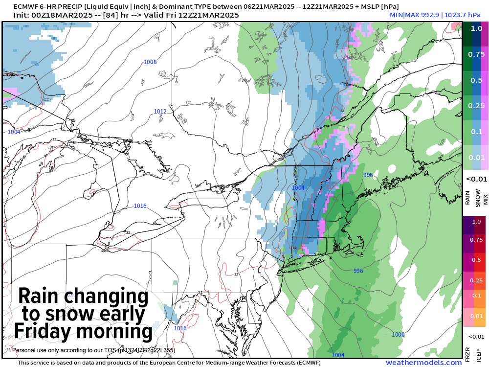
Clouds thicken Thursday evening, and rain will move in with an incoming cold front draped southward off of a low pressure system passing to our north. However, there is growing support for a stronger secondary low to develop south of our region overnight, pulling cold air to the western MA region.
This will probably change rain to snow in at least the western hilltowns, Berkshires, northwest CT, SVT/SWNH, and northern CMass into eastern Franklin County with a coating to 2” of new snow possible by Friday morning, with a rain/snow mix in the valley down to Hartford and east through eastern Hampden County, southern CMass and northeast CT.
But even in some of the lower elevations areas we could see fresh coatings by dawn Friday morning.
Again, this is a minor system, but is notable for late-season snow potential.
Precip quits by mid to late Friday morning, and then blustery northwest wind gusts pick up and blow 30-45mph at times ushering in cooler air with highs only in the mid 30s to mid 40s, with lows in the 20s as we dry out.
The weekend looks split, with Saturday being the pick under sunny skies and highs reaching the upper 40s to mid 50s with lows in the 20s.
By Sunday, we may see a few showers and some more clouds, but uncertainty remains. Temps will rise well into the 40s, with lows in the 20s to low 30s.
By Monday, however, another system will be pushing east-northeast out of the Ohio Valley towards New England, and if it arrives early enough we could see some more accumulating wet snow, likely turning to rain.
A busy pattern continues, and we certainly need the precipitation in the ground.
Have a great day!
“Follow your bliss and the universe will open doors for you where there were only walls.”
― Joseph Campbell