
TABLE OF CONTENTS
* Daily Celestials (Sun/Moon Data)
* Sponsor Note
* Morning Discussion
* TIP: Scroll below for sections, or read all
~~~~~~~~~~~~~~~
YOUR DAILY CELESTIALS
~~~~~~~~~~~~~~~~~~~~~~
STAR:
–OUR STAR ROSE AT: 6:58am this morning
–OUR STAR SETS AT: 6:59pm this evening
–TOTAL DAYLIGHT TIME: 12 hours and 1 minute
MOON:
–OUR MOON SETS AT: 8:08am this morning
–MOON SET DIRECTION: West-Southwest
–OUR MOON RISES AT: 10:38pm tonight
–MOON RISE DIRECTION: East-Southeast
–MOON PHASE: Waning Gibbous (91.2%)
~~~~~~~~~~~~~~~~~~~~~~
A NOTE FROM OUR SPONSOR
~~~~~~~~~~~~~~~~~~~~~~
Dave Hayes The Weather Nut is Sponsored by Individual Community Members, Patrons, and Tandem Bagel Company… No matter the weather, Tandem Bagel is always there for you at several valley locations to make your mornings brighter! With *New Pizza Bagels(!)*, along with bagels baked fresh daily (including Gluten-Free options), house-whipped cream cheese, coffee, and tons of lunch options, Tandem is the perfect quick stop for lunch, breakfast, or a coffee and bagel to go.
You can either 1) visit them in Easthampton, Northampton, Hadley, Florence, and/or West Springfield, 2) hire them to cater your next event, or 3) use their super-streamlined online ordering tool by visiting their website and clicking the “Catering” or “Order Online” links.
~~~~~~~~~~~~~~~~~~~~~~
YOUR MORNING DISCUSSION
~~~~~~~~~~~~~~~~~~~~~~
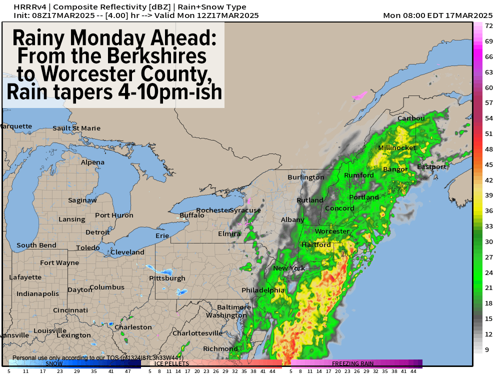
Good morning everybody, we’ve had quite the drink of water overnight as it is, with most areas picking up between .75”-1” of rain, on up to 1.5” in parts of southern VT and the northern Berkshires where we have 3 active (minor) Flood Warnings up for the following rivers:
1. Hoosic River at Williamstown MA into this eve.
2. Walloomsac River at Bennington VT into this eve.
3. Williams River at Rockingham VT into this eve.
As one or two areas of lower pressure develop and ripple south to north along the cold frontal boundary that’s focusing these steady rains over the greater WMass region this morning, progress of this rain region will be slow to the east.
As such, expect a rainy day ahead, with some tapering in the Berkshires, southwest VT and northwest CT by early to mid afternoon.
However, in general, rain won’t fully taper until between 4-10pm from the Berkshires to Worcester County / CMass.
Highs today will basically stay where they are, hanging in the 40s north and 50s south, with lows tonight dipping into the mid to upper 20s in the high terrain of MA, SVT and SWNH and low to mid 30s in the valley, CMass and northern CT. Some showers may change to snow showers before ending in the mountains.
For Tuesday and Wednesday, high pressure builds through the region, and produces mostly sunny skies with highs in the mid to upper 50s Tuesday (low 50s in SVT), and lows down into the low to mid 30s.
On Wednesday, highs should crest into the mid 50s to low 60s under sunny skies with lows in the mid 30s to low 40s.
By Thursday, an upper trough will be pushing into the Great Lakes, and helping to develop another storm that will track northwest of us by Thursday night and Friday.
The day itself looks dry, likely to feature partly sunny skies trending to mostly cloudy with highs in the 55-60º range, though we could see a few first showers by late afternoon or dinner time.
Then another frontal boundary pushes in like today, but less moisture-laden. Rain will develop Thursday night, but the potential is there for a stronger secondary low to pull nearby colder air into this frontal boundary and precip shield near and after midnight into early Friday morning.
If this happens, we could see some wet snow accumulations in the Berkshires, western hilltowns, southern VT, southwest NH and northern Worcester County into the Friday morning commute, so I will keep you updated on this.
After rain and snow quit Friday morning, it will turn blustery, with winds gusting out of the northwest up to 35mph and highs will only rise into the mid 30s to low 40s, with lows in the 20s.
For now, the weekend looks quite nice and seasonable with highs in the 40s to low/mid 50s on Sunday, which is above average temperature-wise.
Have a great day!
“Follow your bliss and the universe will open doors for you where there were only walls.”
― Joseph Campbell