
1. Weather Nut 2025 Support Drive ends *Tonight*.
2. We’re about 185 patrons out of around 59,000 followers from reaching the 4% Reader Support Goal, very close!
3. Why keep Dave on this job for the greater WMass region?
–> 12+ years of faithful service
–> 100s of storms of all types
–> 1000s of daily reports
–> Hyperlocal, Interactive, Dependable
–> Drive Ends *Tonight*, so please chip in *Today*
~~~~~~~~~~~~~~~
TABLE OF CONTENTS
* Daily Celestials (Sun/Moon Data)
* Sponsor Section
* Morning Discussion
* TIP: Scroll to your section, or read more
~~~~~~~~~~~~~~~~~~~~~~
YOUR DAILY CELESTIALS
~~~~~~~~~~~~~~~~~~~~~~
STAR:
–OUR STAR ROSE AT: 7:00am this morning
–OUR STAR SETS AT: 6:58pm this evening
–TOTAL DAYLIGHT TIME: 11 hours and 58 minutes
MOON:
–OUR MOON SET AT: 7:48am this morning
–MOON SET DIRECTION: West-Southwest
–OUR MOON RISES AT: 9:35pm this afternoon
–MOON RISE DIRECTION: East-Southeast
–MOON PHASE: Waning Gibbous (95.5%)
~~~~~~~~~~~~~~~~~~~~~~
>>> A NOTE FROM OUR WEEKEND SPONSOR <<<
Dave Hayes The Weather Nut is Sponsored by Individual Community Members, Patrons, and Gerard, Ghazey & Bates, P.C.
GGBPC is a Northampton-based law firm and is the area’s premier estate and tax planning provider. The firm specializes in Estate Planning, Elder Law, and Tax Law, so be sure to contact GGBPC today to see how they can help you.
Simply click this link to their secure website.
~~~~~~~~~~~~~~~~~~~~~~
YOUR MORNING DISCUSSION
~~~~~~~~~~~~~~~~~~~~~~
Good morning folks, we’ve started our Sunday with areas of patchy dense fog, especially east of the CT River Valley in MA and CT.
Temps are mild, in the 40s and low 50s, and that will set a base for us to hit highs in the low to mid 60s under overcast skies, with some patchy drizzle or scattered showers here and there.
Our storm system that will be responsible for wind and rain production tonight into Monday will be deepening and tracking north-northeast through Lake Huron (the “middle” Great Lake) today and tonight, heading for southern Canada.
WIND
We’re more likely than not to have a stronger temperature inversion in place, meaning it will be a bit more warm aloft than at the surface, and that makes it hard for wind to mix down to the surface, even when a windy area a mile or two over our heads is moving through our region (i.e. “a low level jet streak”).
While I think we should see southerly wind gusts of 25-40mph in the afternoon, and then 30-50mph by this evening and early part of the night before the heavier rain arrives after 8-9pm, our gusts are more likely to be in the lower end of those ranges, with the highest gusts likely occurring in the Berkshires, western hilltowns, Worcester Highlands, etc.
RAIN
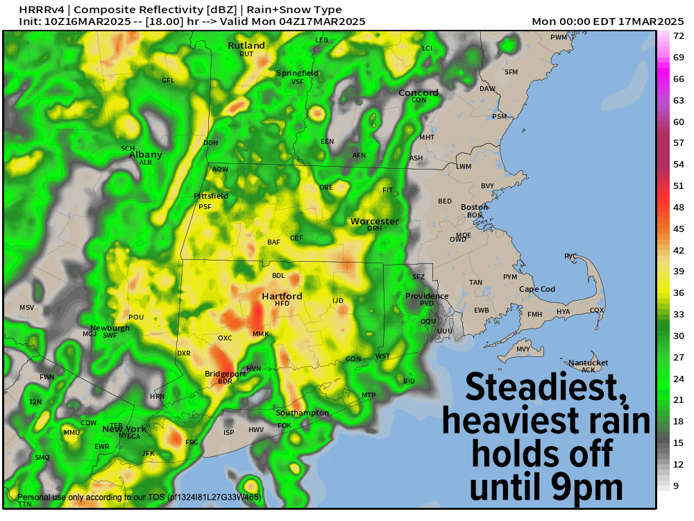
Despite some patchy drizzle, fog and scattered rain showers at times today, it’s going to take a while for the big slug of heavier rain and downpours to push east into the WMass region.
That should happen between 8-10pm, and it should be raining steadily and/or heavily by midnight everywhere.
Lows tonight will hang either side of 50º, and we may see patchy fog in spots as well.
MONDAY
Periods of rain will continue Monday morning, and now it looks like a final areas of showers might take until early to mid-afternoon on Monday to move through the region, so plan for a wet start to the work week.
Highs Monday will climb into the mid to upper 50s and then fall behind the front, with rain tapering off and lows dropping down into the upper 20s to mid 30s as we start to dry out.
FAIR WEATHER MID-WEEK
Tuesday and Wednesday should feature high pressure, sunny skies and highs reaching the upper 50s Tuesday and then the low 60s by Wednesday with lows in the 30s Tuesday night, and either side of 40º by Wednesday night with dry conditions.
Once we get to Thursday, we’ll be watching another inside-running storm system set to pass northwest of us, which will drag another cold front through the WMass region by Friday morning.
Thursday will feature clouds increasing with highs in the mid to upper 50s as another south-to-north oriented band of heavier showers sets up east of the cold front that will push through New England on Friday.
First showers are probable sometime by mid to late afternoon with a showery Thursday night expected.
SNOW BY FRIDAY MORNING?
A wild card with this system will be centered around whether or not a secondary low pressure system develops along the front as it passes through New England, and pulls colder air in faster. If that happens, some of us may change to snow during the pre-dawn hours into early Friday morning, so I will be watching that and will keep you updated.
Friday looks blustery and cool behind that system, with highs in the 40s as northwest winds gust to 20-30mph. Lows will bottom out into the 20s, with a pleasant-looking Saturday to follow with highs near 50º.
Folks, my 2025 Support Drive ends *Tonight*, and we’re about 185 final patrons out of over 59,000 followers away from reaching 4% of readers chipping in any amount.
We’ve achieved this goal over the past 6 or 7 years straight, which has kept me in your service working up to 2500 hours annually to be of service as best as I can.
With your help today (and when you click this link to chip in any small or larger amount within your means), I’m confident we’ll hit this goal again so I can continue on as your community weather nut for our greater WMass region through 2025. Thank you so much! (Venmo, Card, PayPal, Check options at link above)
“Follow your bliss and the universe will open doors for you where there were only walls.”
― Joseph Campbell