
KEEP DAVE ON THE JOB FOR THE WMASS REGION
–> 12+ years of faithful service
–> 100s of storms of all types
–> 1000s of daily reports
–> Need 440 folks out of 59,000+ to step up
–> Drive Ends *This Sunday*, please chip in today
~~~~~~~~~~~~~~~
TABLE OF CONTENTS
* Daily Celestials (Sun/Moon Data)
* Sponsor Note
* Morning Discussion
* TIP: Scroll below for sections, or read all
~~~~~~~~~~~~~~~
YOUR DAILY CELESTIALS
~~~~~~~~~~~~~~~~~~~~~~
STAR:
–OUR STAR ROSE AT: 7:05am this morning
–OUR STAR SETS AT: 6:54pm this evening
–TOTAL DAYLIGHT TIME: 11 hours and 49 minutes
MOON:
–OUR MOON SET AT: 6:54am this morning
–MOON SET DIRECTION: West-Northwest
–OUR MOON RISES AT: 6:29pm this afternoon
–MOON RISE DIRECTION: East-Northeast
–MOON PHASE: Full Worm Moon (99.4%)
~~~~~~~~~~~~~~~~~~~~~~
A NOTE FROM OUR SPONSOR
~~~~~~~~~~~~~~~~~~~~~~
Dave Hayes The Weather Nut is Sponsored by Individual Community Members, Patrons, and Tandem Bagel Company… No matter the weather, Tandem Bagel is always there for you at several valley locations to make your mornings brighter! With *New Pizza Bagels(!)*, along with bagels baked fresh daily (including Gluten-Free options), house-whipped cream cheese, coffee, and tons of lunch options, Tandem is the perfect quick stop for lunch, breakfast, or a coffee and bagel to go.
You can either 1) visit them in Easthampton, Northampton, Hadley, Florence, and/or West Springfield, 2) hire them to cater your next event, or 3) use their super-streamlined online ordering tool by visiting their website and clicking the “Catering” or “Order Online” links.
~~~~~~~~~~~~~~~~~~~~~~
YOUR MORNING DISCUSSION
~~~~~~~~~~~~~~~~~~~~~~
Good morning everybody, well we had a very narrow band of moderate to briefly heavy snow last night that put down a coating to 1” or so basically right through the center third of Massachusetts, with folks south and north of there mostly scratching their heads, wondering what others were talking about.
It truly was the James Taylor Snow Band that set up, literally from Stockbridge to Boston along and north of the Pike at around 11pm, pretty cool to see.
Watch for black ice early, but know that temps are going to come up into the 40s for most of us today, with some upper 30s hanging in southern VT under mostly cloudy skies given today’s onshore flow which is being produced by the counterclockwise circulation of high pressure to our northeast.
Lows tonight will drop into the 20s, so any melting today of existing snow/ice pack (or from overnight snow) will freeze into black ice patches tonight, so just be aware of your surfaces when out late or up early tomorrow morning.
Friday through Sunday will feature Episode 4 of 2025’s version of “The Mildening”, with highs Friday reaching the upper 40s to upper 50s from north to south (most of us will crest into the 50s) under mostly sunny skies as upper ridging moves into the region. Lows will dip into the 30s for most of us under partly cloudy skies.
The weekend will start off with a dry DAY on Saturday, featuring highs reaching the 55-60º range as clouds increase.
I can’t rule out a few stray showers Saturday evening, but any scattered first showers within an increasingly moist southerly flow should hold off until Saturday night or Sunday morning. Lows at night will hang around either side of 50º.
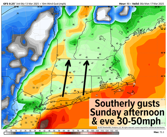
Sunday is looking mild and wild, with highs cranking into the upper 50s to mid 60s under overcast skies with morning showers transitioning into a steadier and heavier rainfall by later afternoon, and maximizing through Sunday night into early Monday morning.
Southerly wind gusts will also be kicking up as high pressure in the western Atlantic Ocean combines with low pressure ripping northeast into southeast Ontario to produce a strong pressure gradient over our region.
This will combine with a strong low level jet streak (i.e. faster moving river of air about a mile or so aloft) moving through the greater WMass region and produce southerly gusts of 30-50mph or so. Some isolated wind damage and power outages are possible.
All of this atmospheric energy in the form of rain and wind will precede a cold frontal passage that moves through toward mid-day Monday which will switch the wind from south to west, and cause the rain to stop Monday afternoon, cooling us down to near freezing at night as we begin to dry out.
Tuesday and Wednesday look to feature fair weather with highs in the 50s Tuesday and the low to mid 60s Wednesday prior to another frontal boundary pushing more rainfall into our region sometime on Thursday.
Have a great day and if you haven’t had a chance yet and would like me to stick around, I’m looking for around 440 final patrons out of 59k followers to chip in any amount by Sunday ($10 once, $3/month, whatever feels right) to help me reach my 4% reader-support goal (1 in 25 folks chipping in what they can).
“Follow your bliss and the universe will open doors for you where there were only walls.”
― Joseph Campbell