
WE’RE STILL UNDER 80% TO REACHING THIS YEAR’S SUPPORT DRIVE GOAL OF 4% READER SUPPORT WITH JUST 5 DAYS REMAINING TO HELP DAVE IN THE BUILDING…
$10+ once, $2-5/month, whatever works for you, is hugely helpful…
–> 12+ years, 100s of storms, 1000s of daily reports
–> Keep Dave on the job thru mild & wild WMass weather
–> 70% towards the 4% reader goal, Drive ends *this* Sunday
–> ^^ SecureClick to support Dave’s work ^^
~~~~~~~~~~~~~~~
TABLE OF CONTENTS
* Daily Celestials (Sun/Moon Data)
* Sponsor Note
* Morning Discussion
* TIP: Scroll below for sections, or read all
~~~~~~~~~~~~~~~
YOUR DAILY CELESTIALS
~~~~~~~~~~~~~~~~~~~~~~
STAR:
–OUR STAR ROSE AT: 7:08am this morning
–OUR STAR SETS AT: 6:52pm this evening
–TOTAL DAYLIGHT TIME: 11 hours and 44 minutes
MOON:
–OUR MOON RISES AT: 4:20pm this afternoon
–MOON RISE DIRECTION: East-Northeast
–OUR MOON SETS AT: 6:34am tomorrow morning
–MOON SET DIRECTION: West-Northwest
–MOON PHASE: Waxing Gibbous (92.4%)
~~~~~~~~~~~~~~~~~~~~~~
A NOTE FROM OUR SPONSOR
~~~~~~~~~~~~~~~~~~~~~~
Dave Hayes The Weather Nut is Sponsored by Individual Community Members, Patrons, and Tandem Bagel Company… No matter the weather, Tandem Bagel is always there for you at several valley locations to make your mornings brighter! With *New Pizza Bagels(!)*, along with bagels baked fresh daily (including Gluten-Free options), house-whipped cream cheese, coffee, and tons of lunch options, Tandem is the perfect quick stop for lunch, breakfast, or a coffee and bagel to go.
You can either 1) visit them in Easthampton, Northampton, Hadley, Florence, and/or West Springfield, 2) hire them to cater your next event, or 3) use their super-streamlined online ordering tool by visiting their website and clicking the “Catering” or “Order Online” links.
~~~~~~~~~~~~~~~~~~~~~~
YOUR MORNING DISCUSSION
~~~~~~~~~~~~~~~~~~~~~~
Good morning everybody, well well well, Spring is really starting to surge now as we head towards the Vernal Equinox which arrives a week from Thursday at 5:00am, representing the beginning of Astronomical Spring, so the timing is quite good.
Harvey Leonard, one of the legendary Boston Meteorologists of the 20th and 21st centuries to date was a guy I grew up watching and learning from, and I had the great honor and pleasure to meet him this past Summer.
The very first storm he covered on Boston news (Channel 7, WHDH) was the Mother’s Day Snowstorm of May 9-10, 1977, which to this day represents the late-season outlier for a major snowstorm in southern New England.
He is noted for saying that “Harvey-ological Winter” lasts until mid-May.
So while I always caution that we could see accumulating snow into at least April if not the first half of May, our winter pattern is rapidly breaking down now as warmer air is surging and colder is retreating north.
We *do* have one last chance for some of us to wake up with a thin, fresh white blanket on the ground early Thursday morning, but after that, I think we’re about cooked for a Winter that was fairly solid in terms of cold, and almost-to-average for snowfall, despite not having any major snowstorms – a winter season we haven’t seen for several years.
As for our weather into early next week, let’s bust out a fresh set of double—dashes just for this occasion, because life’s too short to not scan more bulleted info lists!
SUMMARY OF EARLY SPRING-INESS
–Gorgeous Tuesday ahead!
–Sunny, highs upper 50s to mid 60s
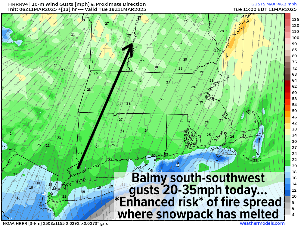
–Southerly breezes pick up by afternoon, and gust 20-35mph later
–Elevated risk of fire spread exists this afternoon, so watch any early burns
–Cold front approaches tonight, with lows in the mid 20s to mid 30s
–A shower is possible
–Wednesday is colder, with highs in the 40s under partly to mostly sunny skies and a light north wind
–We cool down Wednesday night with another frontal boundary nearby and a weak system passing north of us
–This may be enough to spark a period of light snow with lows in the upper 20s to low 30s
–A coating to 2” is possible in areas well north of the Pike, more like northern MA into SVT/SWNH but I will keep you updated on what seems to be Winter’s last smooch
–Any precip ends Thursday morning, with highs reaching into the low to mid 40s under partly sunny skies after early clouds. Lows dip to the low to mid 30s
–Friday through Sunday should see a resurgence in higher temps with dry conditions and highs well into the 50s Friday and Saturday under partly sunny to mostly cloudy skies with lows in the 30s
–By Sunday, a strong cold front will be approaching from the west
–This will induce strong southerly winds that may gust 30-50mph at times as we get deeper into the afternoon
–In addition rain, heavy at times, should develop sometime on Sunday into Sunday night, possibly lasting into early Monday
–Highs will climb into the upper 50s to mid 60s Sunday, and back down into the 50s for Monday as a milder air mass sets up shop in the greater WMass region.
Have a great day and if you rely on my work, I hope you’ll help to retain this resource in 2025… My annual support drive ends *this coming* Sunday and we’re still less than 80% towards my modest annual 4% reader support goal… if you enjoy my reporting, please securely click to support it in any amount below… $10, $3/month, more if you can, whatever works for you, it all helps!
“Follow your bliss and the universe will open doors for you where there were only walls.”
― Joseph Campbell