–> 12+ years, 100s of storms, 1000s of daily reports
–> Keep Dave on the job thru mild & wild WMass weather
–> 70% towards the 4% reader goal, Drive ends *this* Sunday
–> ^^ SecureClick to support Dave’s work ^^
~~~~~~~~~~~~~~~
TABLE OF CONTENTS
* Daily Celestials (Sun/Moon Data)
* Sponsor Note
* Morning Discussion
* TIP: Scroll below for sections, or read all
~~~~~~~~~~~~~~~
YOUR DAILY CELESTIALS
~~~~~~~~~~~~~~~~~~~~~~
STAR:
–OUR STAR ROSE AT: 7:10am this morning
–OUR STAR SETS AT: 6:51pm this evening
–TOTAL DAYLIGHT TIME: 11 hours and 41 minutes
MOON:
–OUR MOON RISES AT: 3:11pm this afternoon
–MOON RISE DIRECTION: East-Northeast
–OUR MOON SETS AT: 6:11am tomorrow morning
–MOON SET DIRECTION: West-Northwest
–MOON PHASE: Waxing Gibbous (86.1%)
~~~~~~~~~~~~~~~~~~~~~~
A NOTE FROM OUR SPONSOR
~~~~~~~~~~~~~~~~~~~~~~
Dave Hayes The Weather Nut is Sponsored by Individual Community Members, Patrons, and Tandem Bagel Company… No matter the weather, Tandem Bagel is always there for you at several valley locations to make your mornings brighter! With *New Pizza Bagels(!)*, along with bagels baked fresh daily (including Gluten-Free options), house-whipped cream cheese, coffee, and tons of lunch options, Tandem is the perfect quick stop for lunch, breakfast, or a coffee and bagel to go.
You can either 1) visit them in Easthampton, Northampton, Hadley, Florence, and/or West Springfield, 2) hire them to cater your next event, or 3) use their super-streamlined online ordering tool by visiting their website and clicking the “Catering” or “Order Online” links.
~~~~~~~~~~~~~~~~~~~~~~
YOUR MORNING DISCUSSION
~~~~~~~~~~~~~~~~~~~~~~
Good morning everybody, before I get started just a word for the middle-aged and older folks out there: when you’re walking down stairs and you’re tired, stop (especially if you have socks on).
Wake yourself up a bit, steady yourself, turn on your core, proceed slowly, and keep your weight on top of your hips or barely forward, and focus on getting down the stairs only.
Yours truly, tired and lost in thought, got to the 4th to last step and fell backwards and almost cracked my back or head, but luckily I just have some bruised mid-back ribs to show for it.
As for our weather, it’s a lot less exciting than what I went through last night, and after our busy and very cold winter, that’s a good thing.
It’s also milder and will be for much of this week into the upcoming weekend.
For today, a Clipper that brought some snow showers mostly north of MA overnight will track east and away from New England, staying north of the greater WMass region.
This will allow any morning clouds to dissipate and empty into a mostly sunny day with westerly breezes up to 20mph, which will support high temps mostly in the 50s (perhaps some areas of SVT hang near the upper 40s).
For tonight, lows will dip into the upper 20s to mid 30s under clear skies, so watch for black ice that forms due to melting snowpack and refreezing.
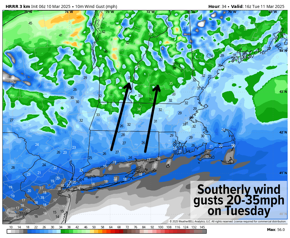
On Tuesday, southerly flow will develop over the region with highs climbing further and reaching the mid 50s to low 60s under sunny skies!! This will be accompanied by southerly gusts of 20-35mph ahead of an incoming cold front. Clouds will increase at night as lows dip into the upper 20s to mid 30s with a spot shower possible.
Wednesday will be sunny but colder behind the front with highs in the upper 30s to mid 40s or so accompanied by a light northwest wind.
Clouds will increase Wednesday night and a weak Clipper system will whip west to east through our region which may bring some light snow overnight into very early Thursday morning with lows near freezing.
If the precip lasts into mid to later Thursday morning it will definitely change to rain, but I can’t rule out a coating to an inch of snow overnight into Thursday AM.
Highs on Thursday will reach the 40s and lows will dip into the low to mid 30s as we clear out.
The Friday through Sunday stretch looks borderline warm!
Highs on Friday should climb into the mid to upper 50s, with upper 50s to mid 60s by the weekend.
Friday and Saturday look mostly sunny with high pressure building through, but a strong cold front will push into NY/PA by Sunday. This will increase cloudiness throughout our region and kick up southerly gusts of 20-30mph into Saturday night, likely increasing to 25-40mph on Sunday before rain arrives toward mid-day into the afternoon and night. Rain may fall heavily at times as well.
I don’t expect that we’re done with cool temps, and we’re just jumping into Spring, as it appears by later March a substantial cool down is possible.
Have a great day and I hope we can stick together in 2025, as my annual support drive ends *this coming* Sunday and still about 70% toward reaching my annual 4% reader support goal (secure click to support Dave’s work through 2025 below)
“Follow your bliss and the universe will open doors for you where there were only walls.”
― Joseph Campbell
