
YOUR NUTSHELL: We’ve got one more day of wildfire smoke at ground level and displayed as hazy skies as our first summer heat surge moves through today and tomorrow, peaking today. Hazy, hot and humid with isolated showers/storms by later afternoon begets a bigger outbreak of showers, downpours and potentially strong t-storms on Friday afternoon/eve, mostly north of the CT/MA state line, with isolated street/flash flooding possible. Saturday showers give way to drying for Sunday and Monday before more showers arrive Tuesday.
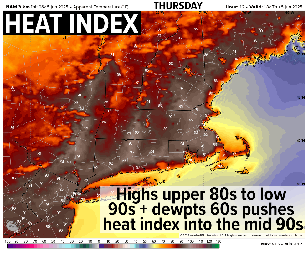
TABLE OF CONTENTS
* Daily Celestials (Sun/Moon)
* Sponsor Section
* Morning Discussion
~~~~~~~~~~~~~~~
YOUR DAILY CELESTIALS
~~~~~~~~~~~~~~~~~~~~~~
STAR:
–OUR STAR ROSE AT: 5:15am this morning
–OUR STAR SETS AT: 8:22pm this evening
–TOTAL DAYLIGHT TIME: 15 hours and 7 minutes
MOON:
–OUR MOON RISES AT: 3:11pm this afternoon
–MOON RISE DIRECTION: East
–OUR MOON SETS AT: 2:24am tomorrow morning
–MOON SET DIRECTION: West-Southwest
–MOON PHASE: Waxing Gibbous (71.7%)
~~~~~~~~~~~~~~~~~~~~~~
A NOTE FROM OUR SPONSOR
~~~~~~~~~~~~~~~~~~~~~~
Dave Hayes The Weather Nut is Sponsored by Individual Community Members, Patrons, and Tandem Bagel Company… No matter the weather, Tandem Bagel is always there for you at several valley locations to make your mornings brighter! With *New Pizza Bagels(!)*, along with bagels baked fresh daily (including Gluten-Free options), house-whipped cream cheese, coffee, and tons of lunch options, Tandem is the perfect quick stop for lunch, breakfast, or a coffee and bagel to go.
You can either 1) visit them in Easthampton, Northampton, Hadley, Florence, West Springfield, and/or Ludlow, 2) hire them to cater your next event, or 3) use their super-streamlined online ordering tool by visiting their website and clicking the “Catering” or “Order Online” links.
~~~~~~~~~~~~~~~~~~~~~~
YOUR MORNING DISCUSSION
~~~~~~~~~~~~~~~~~~~~~~
Good morning folks, we’re waking up to one more day of impacts from Canadian wildfire smoke, which has already pushed Air Quality Indices into the 50-100 range across the region, which is *usually* when folks more on the sensitive side feel impacts to respiration, and I think some of us will smell smoke again today and it certainly will cause skies to be hazy.
In addition, and upper ridge peaks over the region today, causing temps to soar into the upper 80s to low 90s (with maybe a few mid 90s readings) and heat indices (the combo of air temp and dewpoint temp) to easily rise into the mid 90s.
These readings are just below Heat Advisory criteria, but it’s the first truly hot day of our nascent 2025 warm season, so take it easy out there, stay hydrated, seek shade when you can, and stay in air conditioning if you have pulmonary issues… you know the drill.
By later this afternoon, we should see some isolated showers, downpours or thunderstorms form, likely in elevated terrain zones like the Berkshires, SVT or western hilltowns as unstable air is forced skyward by the presence of mountains (a/k/a “orographic uplift”).
Any activity should die down with the setting sun but there could be some scattered showers overnight here and there, with lows dropping into the mid to upper 60s with patchy fog possible, especially southern areas.
For Friday, I have some slight concern that some areas could see torrential rainfall, especially along and north of the Pike in MA, up into SVT/SWNH. In addition, some isolated flash flooding may result, and certainly street flooding is expected in spots that get the heaviest rainfall.
This activity will be due to an incoming cold front and a wave that will track ahead of it, which will focus an outbreak of showers and thunderstorms by tomorrow afternoon (some showers in the morning are also possible), and I can’t rule out a few strong to severe t-storms with strong gusty winds by afternoon.
Highs Friday will peak into the upper 70s to mid 80s and it will be quite humid, with lows in the low 60s with potential for showers as thunder potential dies down.
Saturday morning into about mid-afternoon or so should feature some cold frontal showers at times, with cooler highs in the 70s, drying by late afternoon into the evening as the cold front moves through the region.
Please note that I will need to update these Saturday impacts and timing in future reports as we get closer. Lows will dip to the upper 50s.
Once we get to Sunday and Monday, high pressure will build in from our northwest, which will promote sunshine and cooler northwest flow with highs in the mid to upper 70s and lows in the 50s.
By Tuesday, however another frontal boundary will be working towards the region with more rainfall, likely lasting into Tuesday night and possibly Wednesday morning before we begin to dry out once again.
Stay hydrated today folks, take it easy, and have a great day!
“Follow your bliss and the universe will open doors for you where there were only walls.”
― Joseph Campbell